Adelaide is the capital city of the state of South Australia, and the fifth-most populous city of Australia. In June 2017, Adelaide had an estimated resident population of 1,333,927. Adelaide is home to more than 75 percent of the South Australian population, making it the most centralised population of any state in Australia.

The Australian Labor Party is a major centre-left political party in Australia. The party has been in opposition at the federal level since the 2013 election. Bill Shorten has been the party's federal parliamentary leader since 13 October 2013. The party is a federal party with branches in each state and territory. Labor is in government in the states of Victoria, Queensland, Western Australia, and in both the Australian Capital Territory and Northern Territory. The party competes against the Liberal/National Coalition for political office at the federal and state levels. It is the oldest political party in Australia.
Australian English is the set of varieties of the English language native to Australia. Although English has no official status in the Constitution, Australian English is the country's national and de facto official language as it is the first language of the majority of the population.

New South Wales is a state on the east coast of Australia. It borders Queensland to the north, Victoria to the south, and South Australia to the west. Its coast borders the Tasman Sea to the east. The Australian Capital Territory is an enclave within the state. New South Wales' state capital is Sydney, which is also Australia's most populous city. In March 2018, the population of New South Wales was over 7.9 million, making it Australia's most populous state. Just under two-thirds of the state's population, 5.1 million, live in the Greater Sydney area. Inhabitants of New South Wales are referred to as New South Welshmen.

Sydney is the state capital of New South Wales and the most populous city in Australia and Oceania. Located on Australia's east coast, the metropolis surrounds Port Jackson and extends about 70 km (43.5 mi) on its periphery towards the Blue Mountains to the west, Hawkesbury to the north, the Royal National Park to the south and Macarthur to the south-west. Sydney is made up of 658 suburbs, 40 local government areas and 15 contiguous regions. Residents of the city are known as "Sydneysiders". As of June 2017, Sydney's estimated metropolitan population was 5,131,326, and is home to approximately 65% of the state's population.

Super Rugby is a professional men's rugby union competition involving teams from Argentina, Australia, New Zealand, South Africa and Japan. Building on various Southern Hemisphere competitions dating back to the South Pacific Championship in 1986, with teams from a number of southern nations, Super Rugby started as the Super 12 in the 1996 season with 12 teams from Australia, New Zealand and South Africa. The Super 12 was established by SANZAR after the sport became professional in 1995.

In Australia, electoral districts for the Australian House of Representatives are called divisions or more commonly referred to as electorates or seats. There are currently 150 single-member electorates for the Australian House of Representatives.
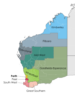
Names such as the South West or South West corner, when used to refer to a specific area of Western Australia, denote a region that has been defined in several different ways.

Alexandrina Council is a local government area in the Fleurieu and Kangaroo Island region of South Australia. The Alexandrina Council was formed on 1 July 1997 by the amalgamation of the District Council of Port Elliot and Goolwa, the District Council of Strathalbyn and a portion of the District Council of Willunga. The council is divided into five wards: Nangkita Kuitpo, Angas Bremer, Port Elliot Middleton, Strathalbyn and Goolwa Hindmarsh Island.
Kaurna is a Pama-Nyungan language historically spoken by the Kaurna peoples of the Adelaide Plains of South Australia. The people of the Adelaide plains are known as the Kaurna people in contemporary times, but the Kaurna nation is made up of various tribal clan groups, each with their own parnkarra district of land, each having had their own dialectal form of language. These dialects were historically spoken in the area of the Adelaide Plains bounded by Crystal Brook and Clare in the north, Cape Jervis in the south, and just over the Mount Lofty ranges. It ceased to be spoken on an everyday basis in the 19th century, but, in a process that began in the 1990s, is being reclaimed and re-introduced.
New Hamburg may refer to:

The states and territories are the first-level administrative divisions of the Commonwealth of Australia. They are the second level of government in Australia, located between the federal and local government tiers.

Australia, officially the Commonwealth of Australia, is a sovereign country comprising the mainland of the Australian continent, the island of Tasmania and numerous smaller islands. It is the largest country in Oceania and the world's sixth-largest country by total area. The neighbouring countries are Papua New Guinea, Indonesia and East Timor to the north; the Solomon Islands and Vanuatu to the north-east; and New Zealand to the south-east. The population of 25 million is highly urbanised and heavily concentrated on the eastern seaboard. Australia's capital is Canberra, and its largest city is Sydney. The country's other major metropolitan areas are Melbourne, Brisbane, Perth and Adelaide.
The Gazetteer of Australia is an index or dictionary of the location and spelling of geographical names across Australia. Geographic names include towns, suburbs and roads, plus geographical features such as hills, rivers, and lakes.

Lands administrative divisions of Australia are the cadastral divisions of Australia for the purposes of identification of land to ensure security of land ownership. Most states term these divisions as counties, parishes, hundreds, and other terms. The eastern states of Queensland, New South Wales, Victoria and Tasmania were divided into counties and parishes in the 19th century, although the Tasmanian counties were renamed land districts in the 20th century. Parts of South Australia (south-east) and Western Australia (south-west) were similarly divided into counties, and there were also five counties in a small part of the Northern Territory. However South Australia has subdivisions of hundreds instead of parishes, along with the Northern Territory, which was part of South Australia when the hundreds were proclaimed. There were also formerly hundreds in Tasmania. There have been at least 600 counties, 544 hundreds and at least 15,692 parishes in Australia, but there are none of these units for most of the sparsely inhabited central and western parts of the country.
Suburbs and localities are the names of geographic subdivisions in Australia, used mainly for address purposes. The term locality is used in rural areas, while the term suburb is used in urban areas. Australian postcodes closely align with the boundaries of localities and suburbs.
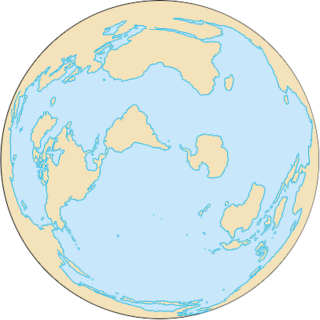
The Southern Ocean, also known as the Antarctic Ocean or the Austral Ocean, and the "Southern Icy Ocean".</ref> comprises the southernmost waters of the World Ocean, generally taken to be south of 60° S latitude and encircling Antarctica. As such, it is regarded as the fourth largest of the five principal oceanic divisions: smaller than the Pacific, Atlantic, and Indian Oceans but larger than the Arctic Ocean. This ocean zone is where cold, northward flowing waters from the Antarctic mix with warmer subantarctic waters.

The County of Hindmarsh is one of the 49 cadastral counties of South Australia. It was proclaimed by Governor George Grey in 1842 and named for Governor John Hindmarsh.