
Newton is a city in Middlesex County, Massachusetts, United States. It is roughly 8 miles (13 km) west of downtown Boston, and comprises a patchwork of thirteen villages. The city borders Boston to the northeast and southeast, Brookline to the east, Watertown and Waltham to the north, and Weston, Wellesley, and Needham to the west. At the 2020 U.S. census, the population of Newton was 88,923.

Auburndale is one of the thirteen villages within the city of Newton in Middlesex County, Massachusetts, United States. It lies at the western end of Newton near the intersection of interstate highways 90 and 95. It is bisected by the Massachusetts Turnpike. Auburndale is surrounded by three other Newton villages as well as the city of Waltham and the Charles River. Auburndale is the home of Williams and Burr elementary schools, as well as Lasell College. Auburndale Square is the location of the Plummer Memorial Library, which is run by the Auburndale Community Library and no longer affiliated with the Newton Free Library, the Turtle Lane Playhouse, and many small businesses.

Chestnut Hill is a wealthy New England village located six miles (10 km) west of downtown Boston, Massachusetts, United States. It is best known for being home to Boston College and a section of the Boston Marathon route. Like all Massachusetts villages, Chestnut Hill is not an incorporated municipal entity. It is located partially in Brookline in Norfolk County; partially in the city of Boston in Suffolk County, and partially in the city of Newton in Middlesex County. Chestnut Hill's borders are defined by the 02467 ZIP Code. The name refers to several small hills that overlook the 135-acre Chestnut Hill Reservoir rather than one particular hill.
Newton Upper Falls is one of the thirteen villages within the city of Newton in Massachusetts, United States. The village is listed as the Newton Upper Falls Historic District on the National Register of Historic Places.

West Newton is one of the thirteen villages within the city of Newton in Middlesex County, Massachusetts, United States.

Waban is one of the thirteen villages within the city of Newton in Middlesex County, Massachusetts, United States.
The West Newton Village Center Historic District encompasses the heart of the village of West Newton, in the city of Newton, Massachusetts in the United States. It extends along Washington Street between Lucas Court in the west and Davis Court in the east, and includes a few properties on immediately adjacent side streets, including Watertown Street and Waltham Street. The village is the second-largest of Newton's commercial centers and is the best-preserved of its late 19th and early 20th century village centers. The district was listed on the National Register of Historic Places in 1990.

The West Newton Hill NR Historic District is a residential National Register historic district in the village of West Newton, in the city of Newton, Massachusetts in the United States. It is composed of a cohesive collection of spacious houses built in the second half of the 19th century, representing the development of the West Newton area as a fashionable railroad suburb. The district was listed on the National Register of Historic Places in 1986.
The Bartlett–Hawkes Farm is a historic house at 15 Winnetaska Road, in the Waban village of Newton, Massachusetts. With its oldest portion dating to about 1736, it is the oldest surviving building in Waban. Enlarged several times, it was moved to its present location from Beacon Street in 1915. It was listed in the National Register of Historic Places on September 4, 1986.

The Brae Burn Road Historic District is a residential historic district on Brae Burn and Windermere Roads in Newton, Massachusetts. It encompasses as modest residential subdivision that was laid out in the then-rural area of Auburndale in 1911. Many of its houses were designed by the regionally notable firm of Gay & Proctor, and represent a well-preserved collection of modestly scaled Craftsman and Colonial Revival style houses. The district includes 26 houses. The district was listed on the National Register of Historic Places in 1990.

The John Buckingham House is a historic house at 33–35 Waban Street in the Newton Corner village of Newton, Massachusetts. Built about 1864, it is a good local example of Second Empire architecture, typical of built at that time for upper middle class commuters to Boston. It was listed on the National Register of Historic Places in 1986.

The Commonwealth Avenue Historic District of Newton, Massachusetts, encompasses roughly the eastern half of Commonwealth Avenue, extending from Waban Hill Road, near the city line with Boston, westward to Walnut Street. The roadway was laid out in 1894 and completed in 1895. Its design was influenced in part by the local residents, who were willing to give land for some of the route, and the design of Boston portions of the road, in which Frederick Law Olmsted was involved. Construction of the roadway was followed by the construction of fashionably large residences along its route, which took place mostly between the road's construction and about 1920. The district includes 188 residential properties, which are mainly built in the revival styles popular in the early 20th century. The district was added to the National Register of Historic Places in 1990.
The Farlow Hill Historic District is a residential historic district in the Newton Corner area of Newton, Massachusetts, United States. It includes houses on Shornecliffe Road, Beechcroft Road, Farlow Road, Huntington Road, and a few properties on immediately adjacent streets. Most of the houses in the district were built between 1899 and the late 1920s and are either Craftsman or Colonial Revival in their style. The area was created by the subdivision of the estate of John Farlow, and includes 37 large and well-appointed houses, generally architect-designed, on ample lots. The district was listed on the National Register of Historic Places in 1990.

The Gray Cliff Historic District is a residential historic district encompassing a cluster of exceptionally high quality houses built in Newton, Massachusetts, between about 1890 and 1940. When first listed on the National Register of Historic Places in 1986, it included only the eight houses at 35, 39, 43, 53, 54, 64, 65, and 70 Gray Cliff Road, which were predominantly Shingle style house built before the turn of the 20th century. The district was expanded in 1990 to include an adjacent area known as The Ledges, where the houses were built between 1900 and 1940, and are mainly Colonial Revival and Tudor Revival in their styling.

The Old Chestnut Hill Historic District encompasses the historic residential heart of the Newton portion of Chestnut Hill, Massachusetts. When first listed on the National Register of Historic Places in 1986, the district extended along Hammond Street, between Beacon Street and the MBTA Green Line right-of-way, and along Chestnut Hill Road between Hammond and Essex, including properties along a few adjacent streets. The district was expanded in 1990 to include more of Chestnut Hill Road and Essex Road, Suffolk Road and the roads between it and Hammond, and a small section south of the Green Line including properties on Hammond Street, Longwood Road, and Middlesex Road. A further expansion in 1999 added a single property on Suffolk Road.

The Pine Ridge Road–Plainfield Street Historic District encompasses a residential subdivision in the Waban section of Newton, Massachusetts. It includes 44 properties on Pine Ridge Road and Plainfield Street between Chestnut Street and Upland Road, and includes a few properties on the latter two streets. The area was laid out for development in the 1880s after the arrival of suburban rail service, and was built out by the 1930s. The district was listed on the National Register of Historic Places in 1990.

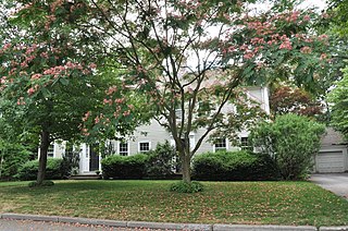
The Second C. A. Sawyer House is a historic house at 86 Waban Ave. in Newton, Massachusetts. The 2+1⁄2-story brick building was designed by Derby and Robinson and built in 1919. It is a well-executed example of Colonial Revival styling in brick, and demonstrates infill construction in established neighborhoods. It is the second of three houses designed by Derby and Robinson for Charles Adrian Sawyer, a builder, and built between 1910 and 1926.

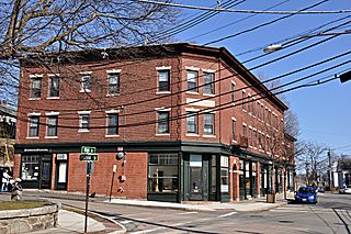
Strong's Block is a historic commercial building at 1637–1651 Beacon Street in the center of Waban Village, in the city of Newton, Massachusetts. Built in 1896, this 2+1⁄2-story brick Flemish Revival structure is one of a small number of surviving 19th century commercial blocks in the city. The building was designed by Waban resident Lewis H. Bacon for William Strong, another local resident, who sought to capitalize on the construction of the nearby Circuit Railroad.

The Chestnut Hill Historic District encompasses the historic portion of the village of Chestnut Hill that lies in Brookline, Massachusetts, with only slight overlap into adjacent Newton. The 70-acre (28 ha) district is bounded on the north by Middlesex Road, on the east by Reservoir Lane, on the south by Crafts Road and Massachusetts Route 9, and on the west by Dunster Road. A small portion of the district extends south of Route 9, including a few houses and the Baldwin School on Heath Street. The district was listed on the National Register of Historic Places on October 17, 1985.

The Waban Library Center is a library located in a historic building at 1608 Beacon Street in Newton, Massachusetts. The building is a modest 1½ story Tudor Revival brick building, with a gabled slate roof and raised end walls. A cross-gabled entry area projects from the center of the front facade. It was designed by Densmore, LeClear & Robbins, and built in 1929 with funds raised by subscription from Newton's citizens. The building was listed on the National Register of Historic Places in 1990.


