
West Virginia is a state in the Appalachian, Mid-Atlantic and Southeastern regions of the United States. It is bordered by Pennsylvania to the northeast, Maryland to the east and northeast, Virginia to the southeast, Kentucky to the southwest, and Ohio to the northwest. West Virginia is the 41st-largest state by area and ranks 38th in population, with a population of 1,795,045 residents. The capital and largest city is Charleston.

The east coast of the United States, also known as the Eastern Seaboard, the Atlantic Coast, and the Atlantic Seaboard, is the coastline along which the eastern United States meets the North Atlantic Ocean. Regionally, the term refers to the coastal states and area east of the Appalachian Mountains that have shoreline on the Atlantic Ocean, from north to south, Maine, New Hampshire, Massachusetts, Rhode Island, Connecticut, New York, New Jersey, Delaware, Maryland, Virginia, North Carolina, South Carolina, Georgia and Florida.

Fairmont is a city in Marion County, West Virginia, United States. The population was 18,704 at the 2010 census. It is the county seat of Marion County.
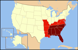
The southeastern United States, also referred to as the American Southeast or simply the Southeast, is broadly the eastern portion of the southern United States and the southern portion of the eastern United States. It comprises at least a core of states on the lower East Coast of the United States and eastern Gulf Coast. Expansively, it includes everything south of the Mason–Dixon line, the Ohio River, the 36°30' parallel, and stretches far west as Arkansas and Louisiana. There is no official U.S. government definition of the region, though various agencies and departments use different definitions.

Mount Storm Lake – also known as New Stony River Reservoir – is a 1,200 acres (4.9 km2) reservoir created in 1965 on the Stony River in Grant County, West Virginia. It serves as a cooling pond for the Dominion 1.6 gigawatt Mount Storm Power Station, which provides electricity to more than two million customers in Northern Virginia. The reservoir stands at an altitude of 3,244 feet (989 m).
West Virginia Route 150 is a 22.5-mile (36.2 km) long north–south scenic state highway in the Marlinton and Gauley Ranger Districts of the Monongahela National Forest in southeast West Virginia. The southern terminus of the route is at West Virginia Route 39 and West Virginia Route 55 northwest of Mill Point. The northern terminus is at U.S. Route 219 and WV 55 north of Edray, near Marlinton.

Mount Porte Crayon is a mountain in the Roaring Plains Wilderness of the Monongahela National Forest in the northeastern corner of Randolph County, West Virginia, USA. It rises to an elevation of 4,770 feet (1,450 m), the elevational climax of the Allegheny Front. The mountain is named for 19th century writer and illustrator David Hunter Strother (1816–88), known as "Porte Crayon", who produced a wide array of early West Virginia landscapes in his work.

Uneeda is an unincorporated community on the Pond Fork River in Boone County in the U.S. state of West Virginia. The town lies along West Virginia Route 85.
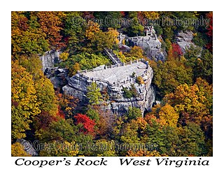
Coopers Rock State Forest is a 12,747-acre (52 km2) state forest in Monongalia and Preston counties in the U.S. state of West Virginia. Its southern edge abuts Cheat Lake and the canyon section of Cheat River, a popular whitewater rafting river in the eastern United States.
Sandyville is an unincorporated community in north central Jackson County, West Virginia, United States. It lies close to the left fork of Sandy Creek, nestled in the hills between Ravenswood and Ripley. It has a population of 1,721 and an average household income of $41,122.

John Kee was a U.S. Democratic politician serving in the United States House of Representatives from 1933 until his death in Washington, D.C. in 1951.
Belva is an unincorporated community and census-designated place in west Nicholas County and north Fayette County, West Virginia, United States; while the CDP only includes the Nicholas County portion, the Fayette County portion is considered part of the community. The town is situated at the bottomland surrounding the convergence of Bells Creek with Twentymile Creek and, subsequently, Twenty Mile Creek with the Gauley River. Belva is also the location of the convergence of two state highways: West Virginia Route 16 and West Virginia Route 39.
Neola is an unincorporated community in northeastern Greenbrier County, West Virginia, United States. It lies along West Virginia Route 92 north of the city of White Sulphur Springs. Its elevation is 2,037 feet (621 m).

Climate change in West Virginia is an ongoing concern. Most of the state has warmed one-half to one degree Fahrenheit (0.28–0.56 °C) in the last century, and heavy rainstorms are becoming more frequent. In the coming decades, a changing climate is likely to increase flooding, harm ecosystems, increase some health problems, and possibly threaten some recreational activities. The average temperature in Charleston, West Virginia, has increased 1.1 °F (0.61 °C) over the last century, and precipitation has increased by up to 10% in many parts of the state.

Turkey Run Wildlife Management Area, is located immediately north of Ravenswood, West Virginia in Jackson County. Turkey Run WMA is located on 27 acres (11 ha), consisting of a fishing lake and some small wooded hills around the lake.
Paynesville is an unincorporated community in McDowell County, West Virginia, United States. Paynesville is located along West Virginia Route 83 at the Virginia border. Paynesville has a post office with ZIP code 24873.

The December 2009 North American blizzard was a powerful nor'easter that formed over the Gulf of Mexico in December 2009, and became a major snowstorm that affected the East Coast of the United States and Canadian Atlantic provinces. The snowstorm brought record-breaking December snowfall totals to Washington, D.C., Baltimore, and Philadelphia.
Hico is a census-designated place (CDP) in Fayette County, West Virginia, United States. Hico is located at the junction of U.S. Route 19 and U.S. Route 60 7 miles (11 km) northeast of Fayetteville. Hico has a post office with ZIP code 25854. As of the 2010 census, its population was 272.

Cora is an unincorporated community in Logan County, West Virginia, United States. Cora is 2 miles (3 km) southwest of Logan, along the Copperas Mine Fork. Cora has a post office with ZIP code 25614. It is part of the Mount Gay-Shamrock census-designated place.

The U.S. state of West Virginia reported its first confirmed case relating to the COVID-19 pandemic on March 17, 2020, becoming the last state to do so. However, the particular patient had been showing symptoms for several days prior. On March 29, 2020, the state reported its first COVID-19 death.


