Winthrop, New York

Last updated

Winthrop, New York
USA New York location map.svg
Red pog.svg
Winthrop
Usa edcp location map.svg
Red pog.svg
Winthrop
Coordinates: 44°47′44″N74°47′9″W / 44.79556°N 74.78583°W / 44.79556; -74.78583
CountryUnited States
State New York
County St. Lawrence
Town Stockholm
Area
[1]
  Total2.80 sq mi (7.25 km2)
  Land2.78 sq mi (7.19 km2)
  Water0.02 sq mi (0.06 km2)
Elevation
338 ft (103 m)
Population
 (2020)
  Total489
  Density176.09/sq mi (68.00/km2)
Time zone UTC-5 (Eastern (EST))
  Summer (DST) UTC-4 (EDT)
ZIP Code
13697
13613 (Brasher Falls)
Area code(s) 315/680
FIPS code 36-82612
GNIS feature ID2584303 [2]

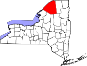
Winthrop is a hamlet and census-designated place (CDP) in the town of Stockholm in St. Lawrence County, New York, United States. As of the 2010 census, it had a population of 510.

The community is in northeastern St. Lawrence County, in the northeastern part of the town of Stockholm. It is bordered to the northeast by the community of Brasher Falls in the town of Brasher. The St. Regis River, a tributary of the St. Lawrence River, forms the southeastern border.

New York State Route 11C passes through Winthrop, leading southwest 3 miles (5 km) to U.S. Route 11 at Stockholm Center, and looping northeast, east, and south 8 miles (13 km) to rejoin Route 11 at Cotey Corners in the town of Lawrence. The village of Potsdam is 13 miles (21 km) southwest of Winthrop. State Route 420 crosses NY 11C in the center of Winthrop; it leads north-northwest 11 miles (18 km) to Massena and south 1.5 miles (2.4 km) to US-11.

Demographics

Historical population
CensusPop.Note
2020 489
U.S. Decennial Census [3]

Related Research Articles

<span class="mw-page-title-main">Alexandria, New York</span> Town in New York, United States

Alexandria is a town in the Thousand Islands region of the U.S. state of New York, within Jefferson County. The town's population was 4,061 at the 2010 United States Census. The town is named after Alexander LeRay, the son of an early developer. The village of Alexandria Bay is within the town.

Diana is a town in Lewis County, New York, United States. The population was 1,709 at the 2010 census. The town is on the northeastern border of the county and is located northeast of Watertown. The northwestern section of Diana is in the Fort Drum military reservation.

<span class="mw-page-title-main">Brasher, New York</span> Town in New York, United States

Brasher is a town in St. Lawrence County, New York, United States. The population was 2,512 at the 2010 census. The town is named after Philip Brasher, an original landowner.

Lawrence is a town in St. Lawrence County, New York, United States. The population was 1,715 at the 2020 census. The town is named after William Lawrence, an early land owner.

<span class="mw-page-title-main">Oswegatchie, New York</span> Town in New York, United States

Oswegatchie is a town in St. Lawrence County, New York, United States. The population was 4,397 at the 2010 census. The name reportedly means "Black Water". It is on the northern border of the county and is adjacent to the city of Ogdensburg.

<span class="mw-page-title-main">Stockholm, New York</span> Town in New York, United States

Stockholm is a town in St. Lawrence County, New York, United States. The population was 3,665 at the 2010 census. The name was assigned by surveyors from Stockholm in Sweden.

Burke is a town in Franklin County, New York, United States. The population was 1,465 at the 2010 census. The town is in the northeastern part of the county, northeast of Malone, the county seat.

Ellisburg is an incorporated town in Jefferson County, New York. The population was 3,474 at the time of the 2010 census. The town is in the southwestern corner of the county and is south of Watertown. Ellisburg is named after early European-American landowners. Among the villages in the town is Ellisburg.

Fishers Landing is a hamlet and census-designated place (CDP) in the town of Orleans in Jefferson County, New York, United States. It is just southwest of Grass Point State Park in the Thousand Islands region of New York. As of the 2010 census the community had a population of 89.

<span class="mw-page-title-main">U.S. Route 11 in New York</span> Highway in New York, U.S.

U.S. Route 11 (US 11) is a part of the United States Numbered Highway System that runs from New Orleans, Louisiana, to the Canada–U.S. border at Rouses Point, New York. In the state of New York, US 11 extends for 318.66 miles (512.83 km) from the Pennsylvania state line south of the Southern Tier city of Binghamton to the Canada–U.S. border at the North Country village of Rouses Point, where it becomes Route 223 upon entering Quebec. The portion of US 11 south of Watertown follows a mostly north–south alignment and is paralleled by Interstate 81 (I-81) while the part of the route north of Watertown follows a more east–west routing, parallel to but not directly on the St. Lawrence River.

Summertown is an unincorporated community and census-designated place (CDP) in Lawrence County, Tennessee, United States. The population of Summertown was 866 at the 2010 census. The town has a ZIP Code of 38483. Some rural areas in neighboring Lewis and Maury counties also use a "Summertown" mailing address, but their population is not included in the Census figures.

<span class="mw-page-title-main">New York State Route 11C</span> State highway in St. Lawrence County, New York, US

New York State Route 11C (NY 11C) is a short state highway located in St. Lawrence County in the northern part of New York in the United States. NY 11C is a northern alternate route of U.S. Route 11 (US 11) between the towns of Stockholm and Lawrence that serves the hamlets of Winthrop and Brasher Falls. NY 11C briefly overlaps with NY 420 in Winthrop. Although NY 11C follows a mostly east–west routing, it was signed as a north–south route until the 2010s.

Fivepointville is an unincorporated community and census-designated place (CDP) in Brecknock Township, Lancaster County, Pennsylvania, United States. As of the 2010 census, the population was 1,156. The town is named for its position at an intersection of five separate roads.

Brasher Falls is the largest hamlet and a census-designated place (CDP) in the town of Brasher in St. Lawrence County, New York, United States. As of the 2010 census, it had a population of 669.

Swartzville is an unincorporated community and census-designated place (CDP) in East Cocalico Township, Lancaster County, Pennsylvania, United States. As of the 2010 census, the population was 2,283.

Fort Covington is a census-designated place (CDP) within the town of Fort Covington, Franklin County, New York, United States. It consists of the hamlet of Fort Covington, as well as a large amount of rural land surrounding the hamlet, such that the CDP occupies about one half of the area within the town limits. The population of the CDP was 1,308 at the 2010 census, out of a total town population of 1,676.

Madrid is the primary hamlet and a census-designated place (CDP) in the town of Madrid in St. Lawrence County, New York, United States. At the 2020 census, it had a population of 736, out of 1,735 in the entire town of Madrid.

Parishville is the primary hamlet and a census-designated place (CDP) in the town of Parishville in St. Lawrence County, New York, United States. As of the 2010 census, it had a population of 647, out of 2,153 in the entire town of Parishville.

Long Lake is a census-designated place (CDP) in the town of Long Lake, Hamilton County, New York, United States. The population was 596 at the 2020 census, out of 791 in the town of Long Lake as a whole.

New Baltimore is the primary hamlet in the town of New Baltimore, Greene County, New York, United States. It is a census-designated place (CDP), first listed as such prior to the 2020 census. The New Baltimore Hamlet Historic District occupies the historic core of the hamlet.

References

  1. "ArcGIS REST Services Directory". United States Census Bureau. Retrieved September 20, 2022.
  2. "Winthrop Census Designated Place". Geographic Names Information System . United States Geological Survey, United States Department of the Interior.
  3. "Census of Population and Housing". Census.gov. Retrieved June 4, 2016.