
The Cambridge Common Historic District is a historic district encompassing one of the oldest parts of Cambridge, Massachusetts. It is centered on the Cambridge Common, which was a center of civic activity in Cambridge after its founding in 1631. It was the site of the election for governor of the Massachusetts Bay Colony in 1636, and was a military barracks site during the American Revolutionary War. The common was gradually reduced in size to its present roughly triangular shape, and surrounded by buildings in the 18th and 19th centuries. In 1973 a historic district encompassing the extant common and everything within 100 feet (30 m) of it was listed on the National Register of Historic Places. In 1987 the district was amended to rationalize the boundary, which overlapped adjacent districts and included portions of some buildings.

The Amherst Central Business District is a historic district encompassing the heart of downtown Amherst, Massachusetts. Centered on the northern section of the long town common, the area has been the civic and commercial heart of the town since the 18th century. The district was listed on the National Register of Historic Places in 1991, and slightly enlarged in 2011.

This is a list of the National Register of Historic Places listings in Detroit, Michigan.

The Lower Highlands Historic District encompasses one of the oldest residential areas of Fall River, Massachusetts. The district is roughly bounded by Cherry, Main, Winter, and Bank Streets, and is located just east of the Downtown Fall River Historic District and directly south of the Highlands Historic District. This area was settled by 1810, has architecture tracing the city's growth as a major industrial center. The historic district was added to the National Register of Historic Places in 1984.

The Cotuit Historic District is a historic district encompassing the heart of the village of Cotuit in Barnstable, Massachusetts. It extends along Main Street from Lowell Street in the north to Sea Street in the south, and includes portions of Ocean View Avenue and properties on adjacent roads. The oldest properties date to the late 18th century, but saw its greatest development during the height of the area's maritime industry in the mid 19th century. In the late 19th and early 20th century the area saw new development as a summer resort area. The district was listed on the National Register of Historic Places in 1987.

The Pleasant–School Street Historic District is a predominantly residential historic district in the Hyannis village of Barnstable, Massachusetts. It includes 37 properties on Pleasant and School Streets, between Main and South Streets, near the center of Hyannis. Pleasant Street was laid out in the 18th century, and School Street was laid out c. 1850, and is distinctive for its cohesive collection of Greek Revival cottages, most of which were owned by mariners active in the coasting trade. The district was listed on the National Register of Historic Places in 1987.

The South Yarmouth/Bass River Historic District is a historic district in the southeastern part of Yarmouth, Massachusetts. It encompasses a predominantly residential area centered on a portion of Old Main Street and South Street between the villages of South Yarmouth and Bass River. The area's history is one of maritime-related industry from the late 18th to late 19th century, and then its growth as a tourist resort community. The district was listed on the National Register of Historic Places in 1990.

The East Village Historic District is a historic district encompassing the center of the East Village of Amherst, Massachusetts, United States. It includes properties on Main Street, North East Street, and South East Street. The village was one of Amherst's principal civic and commercial centers until the arrival of the railroad in Amherst Center in 1853, and remained a primarily residential area thereafter. The district was listed on the National Register of Historic Places in 1986.

The Hadley Center Historic District is an expansive, 2,500-acre (1,000 ha) historic district encompassing the village center of Hadley, Massachusetts. When it was first listed on the National Register of Historic Places in 1977, the district encompassed the town green and 17 buildings that faced it, at the junction of Russell Street and Middle Street. The district was expanded significantly in 1994, adding more than 400 buildings representative of the village's growth from colonial days into the first decades of the 20th century. This expansion encompasses the entirety of a tongue of land extending west from East Street and bounded by a bend in the Connecticut River, which separates Hadley from Northampton. Its oldest property, the Samuel Porter House on West Street, was built in 1713.

The Lincoln–Sunset Historic District is a residential historic district located west of the downtown area of Amherst, Massachusetts. Colloquially known as Millionaire's Row, the district extends along Lincoln and Sunset Avenues between Northampton Street and the campus of the University of Massachusetts, Amherst. This area was one of Amherst's first planned residential subdivisions, and features a large number of high-quality houses, built by merchants, businessmen, and academics. It was added to the National Register of Historic Places in 1993.

The North Amherst Center Historic District encompasses the center of North Amherst, part of the town of Amherst, Massachusetts. It is a well-preserved example of a traditional farming village, centered at the five-way junction of Meadow, Pine, and North Pleasant Streets, and Sunderland and Montague Roads. The area developed as a village center in the early 19th century and has been relatively little changed since the late 19th century. The district was added to the National Register of Historic Places in 1991.
The South Amherst Common Historic District encompasses the village common and surrounding buildings of South Amherst, Massachusetts. This area developed as a rural residential village hub in the 18th and 19th centuries. It was listed on the National Register of Historic Places in 1995.

The North Hadley Historic District encompasses the historic rural village of North Hadley, located between Mount Warner and the Connecticut River in Hadley, Massachusetts. It includes properties on River Drive between Stockwell Road and Stockbridge Street, and includes properties on French, Meadow and Mt. Warner Streets. It is a well-preserved example of a rural farming and mill community, with architecture dating from the late 18th to early 20th centuries. The district was listed on the National Register of Historic Places in 1993.

The Quadrangle–Mattoon Street Historic District is a historic district in Springfield, Massachusetts, bounded by Chestnut Street to the West; State Street to the South; and includes properties on Mattoon, Salem, Edwards and Elliot Streets. Located in the Metro Center, the Quadrangle–Mattoon Street Historic District is one of the few neighborhoods in the Knowledge Corridor lined with historic, restored red-brick Victorian row houses on both sides, covered by tree canopies.

The Scott's Woods Historic District is a historic district on Hillside Street between Randolph Avenue and the Blue Hills Reservation in Milton, Massachusetts. This rural-residential area has a long history, and is named for the Scott family, who were early settlers of the area. This area preserves a concentration of agricultural and residential resources dating from the 18th to the early 20th centuries, with well-preserved houses, barns, and landscapes. The district was listed on the National Register of Historic Places in 1992.
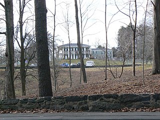
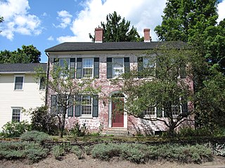
The Green Hill Historic District encompasses historical cross-section of residential housing in Brookline, Massachusetts, dating from the 18th century into the mid-20th century. The district includes properties on Warren, Cottage, and Fairmount Streets, and on Sargent Road, centered on the junction of Warren and Cottage Streets. The oldest houses date to the mid-18th century, and were originally modest Georgian or Federal structures. During the 19th century the area was populated by the summer estates of some of Boston's leading merchant and business families, including members of the Cabot and Perkins families. During the later 19th and early 20th centuries some of Brookline's largest and most architecturally interesting homes were built in this area.

The Hollis Village Historic District encompasses the historic village center of Hollis, New Hampshire. The district is centered on Monument Square, which connects Main Street to Depot Street and Broad Street. It covers about 400 acres (160 ha), and extends along all three of those roads for some distance, and includes properties on Silver Lake Road and Ash Street. Most of the buildings in the district are residential or agricultural in use, and date before the turn of the 20th century; the oldest buildings date to the mid-18th century. The "Always Ready Engine House", which occupies a triangular parcel at the western end of Monument Square, was built in 1859, and is the town's oldest municipal building. Its most architecturally sophisticated building is the town hall, built in 1887 to a design by William M. Butterfield of Manchester. The district represents the growth of a mainly agricultural community over a 200-year period. The district was listed on the National Register of Historic Places in 2001.
The Front Historic District is a predominantly residential historic district in Weymouth, Massachusetts. From the 18th to the 20th century, the area encompassed by this district was one of the more fashionable and desirable neighborhoods adjacent to the commercial Weymouth Landing area. It also contains remnants of a once-flourishing small scale shoe manufacturing industry. The 77-acre (31 ha) district includes nearly 150 resources, primarily residential houses, as well as a school, two cemeteries, and a small cluster of commercial buildings. The district was added to the National Register of Historic Places in 2011.

The Hastings Hill Historic District encompasses a rural crossroads settlement of the early 19th century at the junction of Spruce Street, Hill Street, and Russell Avenue in Suffield, Connecticut. The area includes well-preserved examples of 18th and 18th-century domestic architecture, as well as the 1842 First Baptist Church and a district schoolhouse. It was listed on the National Register of Historic Places in 1979.
The Ascension-Caproni Historic District encompasses a mixed collection of late 19th and early 20th century architecture along Washington, Newcomb, and Thorndike Streets in the Roxbury neighborhood of Boston, Massachusetts. Including religious, residential, commercial, and industrial buildings, it encapsulates the area's transition from industrial to residential uses between about 1850 and 1930. The district was listed on the National Register of Historic Places in 2019.


