
Zoar is a hamlet in the town of Collins in Erie County, New York, United States. [1] Though it is in Collins, mail is postmarked to the Gowanda ZIP code of 14070. It is located on the northern side of Zoar Valley.
Zoar is a hamlet in the town of Collins in Erie County, New York, United States. [1] Though it is in Collins, mail is postmarked to the Gowanda ZIP code of 14070. It is located on the northern side of Zoar Valley.
The area was first inhabited during the Stone Age by Algonquians, a nomadic people. An Algonkian mound from the first or second Stone Age is located on a farm in the area of Rosenburg along Zoar in Gowanda. The mound is believed to be about 3,500 years old, with artifacts including spearheads, copper heads, and stone implements of a crude nature having been excavated from the site. [2]
A little-known fact about the area, not written in any history books and known only to some locals, is that it was a station in the Underground Railroad. A functional tunnel of the Underground Railroad, still in existence today, connects a former train drop-off area of the New York and Lake Erie Railroads near the foot of Gowanda-Zoar Road to an outlet on the property formerly owned by William and Evelyn (Merrill) Glazier, a local surgeon and nurse. Located on Gowanda-Zoar Road, the home was used as a safe house for former slaves escaping to free states and Canada from Southern states around the 1860s and the time of the American Civil War. A homemade railroad sign is posted on the property at the location of the tunnel's outlet.[ citation needed ]
Notable within the Zoar area are maple trees that are approximately 200–300 years old. Many of these trees are located along South Quaker Street and Vail Road. Each spring for decades, the trees have been tapped by locals in order to make maple syrup and maple sugar candy. Several of the trees have become diseased and have died in recent years, with some having to be cut down. Others were cut by the Highway Department when South Quaker Street was repaved and realigned with the section crossing Gowanda-Zoar Road that connects it to Vail Road around 1990–1995.
The Zoar community includes many homes and families living throughout a hilly area with pastures, fields, woods, ponds, and open land. Some residents own farms with dairy cows, horses, and other animals; other residents own homes and property that does not include a farm or farmland.
For many years, the area tree nursery company, Congdon and Weller Nurseries, owned fields in the area and grew trees, shrubs, and other plants and crops there. Presently and for several decades, the farming company, Capella Farms, has operated on South Quaker Street.
On the Vail Road section of Zoar, an excavation site operated by the Gernatt Family of Companies is present. In 2013, residents of the area expressed concerns about changes to the natural environment, the water table, wells, and springs due to a proposed mining expansion by the companies on the site. [3] [4] Most residents in the area get their water from wells or springs, so there is understandable concern about the companies' proposed mining expansion there that would affect the water supply.
Reid's Harley-Davidson Motorcycle Shop, a private, family-owned business, has operated on Gowanda-Zoar Road for decades. The shop is a popular stop for bikers from around the United States and Canada.

Erie County is a county along the shore of Lake Erie in western New York State. As of the 2020 census, the population was 954,236. The county seat is Buffalo, which makes up about 28% of the county's population. Both the county and Lake Erie were named for the regional Iroquoian language-speaking Erie tribe of Native Americans, who lived in the area before 1654. They were later pushed out by the more powerful Iroquoian nations tribes. The county is part of the Western New York region of the state.
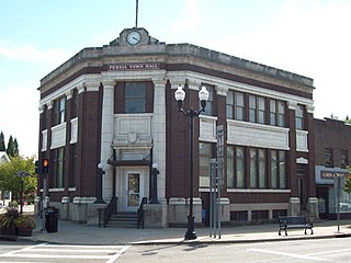
Persia is a town in Cattaraugus County, New York, United States. The population was 2,203 at the 2020 census. It is in the northwest part of the county. The village of Gowanda is partially in the town.

Collins is a town in Erie County, New York, United States. The town is on the south border of the county and is considered to be one of the "Southtowns" of Erie County. The population at the 2010 census was 6,601.

Zoar is a village in Tuscarawas County, Ohio, United States. The population was 172 at the 2020 census. The community was founded in 1817 by Radical Pietists as a utopian Christian community, which survived until 1898.

Gowanda is a village in western New York, United States. It lies partly in Erie County and partly in Cattaraugus County. The population was 2,512 at the 2020 census. The name is derived from a local Seneca language term meaning "almost surrounded by hills" or "a valley among the hills". The Erie County portion of Gowanda is part of the Buffalo–Niagara Falls metropolitan statistical area, while the Cattaraugus County portion is part of the Olean micropolitan statistical area.

Cattaraugus Reservation is an Indian reservation of the federally recognized Seneca Nation of Indians, formerly part of the Iroquois Confederacy located in New York. As of the 2000 census, the Indian reservation had a total population of 2,412. Its total area is about 34.4 mi² (89.1 km²). The reservation stretches from Lake Erie inward along Cattaraugus Creek, along either side of NY 438. It is divided among three counties for census purposes:

North Collins is a town in Erie County, New York, United States. The population was 3,523 at the 2010 census. The name is derived from its parent town, Collins.

Cattaraugus Creek is a stream, approximately 68 miles (109 km) long, in western New York in the United States. The creek drains a wooded rural portion of western New York southwest of Buffalo into Lake Erie. In its lower course it flows primarily through the Cattaraugus Reservation of the Seneca tribe. William Beauchamp identifies the name Cattaraugus as deriving from the Seneca word Gah-ta-ra-ke-ras, meaning "stinking shore" or "foul-smelling river bank." This in turn is likely a loanword from an extinct Attiwandiron, Erie, Wenro, or Wendat (Huron) language, combining the verb root -i'tar-, referring to clay or mud, and -akera(n)-, describing a bad or strong odor: hence, tke'tarakeras, place of strong-smelling mud or clay. This name is a result of the natural gas that oozes from the river mud.
Collins Correctional Facility is a medium security prison in Collins, New York in the United States. The prison is located in the south part of Erie County in the Town of Collins. It is adjacent to the now-closed Gowanda Correctional Facility, another medium-security prison. Both prisons are located north of the Village of Gowanda, at the southern end of Erie County.

New York State Route 78 (NY 78) is a 73.49-mile-long (118.27 km) state highway in western New York in the United States. While it is signed north–south, the southern portion runs in an east–west direction across Wyoming and Erie counties, from its beginning at a junction with NY 19 north of the village of Gainesville to the village of East Aurora. The part of the route north of East Aurora follows a generally north–south alignment to an intersection with NY 18 in the Niagara County town of Newfane, just south of the Lake Ontario shoreline. The route is most closely identified in the region with Transit Road, a major north–south trunk road through the center of Erie and Niagara counties; however, NY 78 does not follow Transit Road for its entire length, nor does Transit Road comprise more than half its length. The highway joins Transit Road north of East Aurora and stays with the road until nearly its end in the city of Lockport.
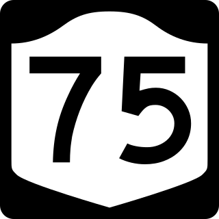
New York State Route 75 (NY 75) is a north–south state highway in Erie County, New York, in the United States. It extends for 20.85 miles (33.55 km) from an intersection with NY 39 in the Collins hamlet of Collins Center to an interchange with NY 5 in the town of Hamburg. The route passes through the village of Hamburg, which serves as the northern terminus of a 2-mile (3.2 km) overlap between U.S. Route 62 (US 62) and NY 75. Past Hamburg, NY 75 connects to the New York State Thruway northwest of the village before ending a short distance from Lake Erie. The portion of NY 75 south of Hamburg is a two-lane rural highway; in contrast, the section north of the village is four lanes wide and serves commercial and residential areas.

New York State Route 438 (NY 438) is a north–south state highway located entirely in Erie County, New York, in the United States. Though signed as north–south, the route runs in an almost east–west direction for 11.78 miles (18.96 km) between Gowanda and Irving through the Cattaraugus Indian Reservation. The southern terminus of the route is at an intersection with U.S. Route 62 (US 62) and NY 39 in Gowanda. Its northern terminus is at a junction with US 20 and NY 5 in Irving. The route was assigned in the mid-1940s. Although it is signed as a state route, the state does not maintain any of the route.

The Buffalo and Jamestown Railroad was a railroad that ran between the towns of Jamestown, NY and Buffalo, NY. It was a predecessor of the Erie Railroad.

The Buffalo and South Western Railroad was a predecessor of the Erie Railroad that ran 89 miles between Jamestown, NY and Buffalo, NY.
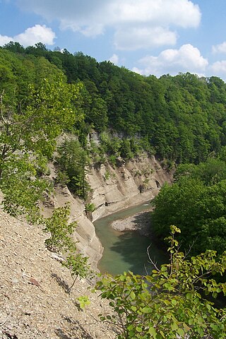
Zoar Valley is an area of deep gorges along the Main and South branches of Cattaraugus Creek in western New York, United States. The valley is located along the border of Erie County and Cattaraugus County, roughly between the villages of Gowanda to the west and Springville to the east.

The Gowanda Correctional Facility was a medium-security prison for men located in Gowanda, New York, United States. The prison was located in the south part of Erie County in the Town of Collins. It was adjacent to the Collins Correctional Facility, another medium-security prison. Both prisons were located north of Village of Gowanda at the southern end of Erie County. It opened in 1994 and closed in 2021.

Daniel R. Gernatt Sr. was an American entrepreneur, businessman, horseman, and dairy farmer in Collins, New York.
Flavia C. Gernatt was an American businesswoman, horsewoman, and dairy farmer in Collins, New York. With her husband Daniel R. Gernatt Sr., she was co-owner of Dan Gernatt Farms, and co-founder of Dan Gernatt Gravel Products, which was the beginning of the Gernatt Family of Companies.
Dan Gernatt Farms is a dairy farming, and horse breeding and racing enterprise, located in the Western New York town of Collins. Daniel R. Gernatt, Sr. and Flavia C. (Schmitz) Gernatt co-owned and established Dan Gernatt Farms in 1938. They built up their farming business, being recognized in the 1950s as having the largest milking dairy herd in Erie County.
Gowanda State Hospital was a hospital located in Gowanda, New York. Its building is now part of Gowanda Correctional Facility.
42°27′24″N78°50′21″W / 42.45667°N 78.83917°W
