
The ACF River Basin is the drainage basin, or watershed, of the Apalachicola River, Chattahoochee River, and Flint River, in the Southeastern United States.

The National Estuarine Research Reserve System is a network of 29 protected areas established by partnerships between the National Oceanic and Atmospheric Administration (NOAA) and coastal states. The reserves represent different biogeographic regions of the United States. The National Estuarine Research Reserve System protects more than 1.3 million acres of coastal and estuarine habitats for long-term research, water-quality monitoring, education, and coastal stewardship.

The Coastal Zone Management Act of 1972 is an Act of Congress passed in 1972 to encourage coastal states to develop and implement coastal zone management plans (CZMPs). This act was established as a United States National policy to preserve, protect, develop, and where possible, restore or enhance, the resources of the Nation's coastal zone for this and succeeding generations.
The Apalachicola River is a river, approximately 160 mi (180 km) long in the state of Florida. The river's large watershed, known as the ACF River Basin, drains an area of approximately 19,500 square miles (50,500 km2) into the Gulf of Mexico. The distance to its farthest head waters in northeast Georgia is approximately 500 miles (800 km). Its name comes from the Apalachicola people, who used to live along the river. It is the largest river in Florida.
The National Ocean Service (NOS), an office within the U.S. Department of Commerce National Oceanic and Atmospheric Administration (NOAA), is responsible for preserving and enhancing the nation's coastal resources and ecosystems along 95,000 miles (153,000 km) of shoreline bordering 3,500,000 square miles (9,100,000 km2) of coastal, Great Lakes, and ocean waters. Its mission is to "provide science-based solutions through collaborative partnerships to address evolving economic, environmental, and social pressures on our oceans and coasts." NOS works closely with many partner agencies to ensure that ocean and coastal areas are safe, healthy, and productive. National Ocean Service scientists, natural resource managers, and specialists ensure safe and efficient marine transportation, promote innovative solutions to protect coastal communities, and conserve marine and coastal places. NOS is a scientific and technical organization of 1,700 scientists, natural resource managers, and specialists in many different fields.

Wells National Estuarine Research Reserve, located in Wells, Maine, USA, is 2,250 acres (9.1 km2) of protected land headquartered at a restored saltwater farm called Laudholm. As a National Estuarine Research Reserve, the Wells Reserve works to expand knowledge of coasts and estuaries, engage people in environmental learning, and involve communities in conservation, all with a goal of protecting and restoring coastal ecosystems around the Gulf of Maine. Wells Reserve funding is largely through the National Oceanic and Atmospheric Administration and the nonprofit Laudholm Trust.
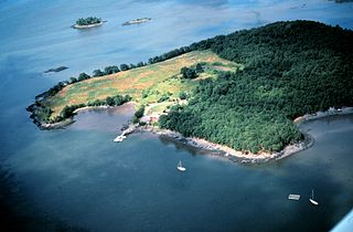
Cape St. George Island is an uninhabited barrier island situated on Florida's North Gulf Coast, south-southeast of St. Vincent Island, west of St. George Island and 8–10 miles south-southwest of the town of Apalachicola in Franklin County, Florida. It was formerly part of St. George Island, but was separated from the main island in 1954, when the U.S. Army Corps of Engineers constructed the ship channel known as Bob Sikes Cut.

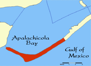
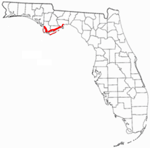
Apalachicola Bay is an estuary and lagoon located on the northwest coast of the U.S. state of Florida. The Apalachicola Bay system also includes St. George Sound, St. Vincent Sound and East Bay, covering an area of about 208 square miles (540 km2). Four islands, St. Vincent Island to the west, Cape St. George Island and St. George Island to the south, and Dog Island to the east, separate the system from the Gulf of Mexico. Water exchange occurs through Indian Pass, West Pass, East Pass and the Duer Channel. The lagoon has been designated as a National Estuarine Research Reserve and the Apalachicola River is the largest source of freshwater to the estuary. Combined with the Chattahoochee River, Flint River, and Ochlockonee River they drain a watershed of over 20,000 square miles (50,000 km2) at a rate of 19,599 cubic feet per second according to the United States Geological Survey in 2002.
Florida's Forgotten Coast is a registered trademark coined in the early 1990s by the Apalachicola Bay Chamber of Commerce. The name is most commonly used to refer to a relatively quiet, undeveloped and largely uninhabited section of coastline stretching from Mexico Beach on the Gulf of Mexico to St. Marks on Apalachee Bay in the U.S. state of Florida. The nearest major cities are Tallahassee, about 90 miles (145 km) northeast of Apalachicola, and Panama City, home of Tyndall Air Force Base, about 60 miles (95 km) to the northwest.
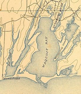
Waquoit Bay is a public national estuary, which is typically used as a research reserve. It is a part of Nantucket Sound and is located on the southern shore of Cape Cod in Massachusetts, USA. This bay forms the border of the towns of Falmouth and Mashpee, Massachusetts.
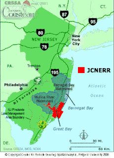
The Jacques Cousteau National Estuarine Research Reserve, located in southeastern New Jersey, encompasses over 110,000 acres (450 km2) of terrestrial, wetland and aquatic habitats within the Mullica River-Great Bay Ecosystem.
Rookery Bay Reserve protects 110,000 acres of coastal lands and waters at the northern end of the Ten Thousand Islands on the gulf coast of Florida, Rookery Bay National Estuarine Research Reserve represents one of the few remaining undisturbed mangrove estuaries in North America.
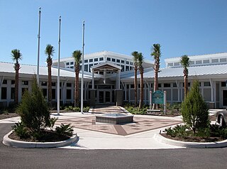
In 1999, the Guana Tolomato Matanzas National Estuarine Research Reserve was designated in St. Johns and Flagler counties, Florida as a part of the National Oceanic and Atmospheric Administration (NOAA) National Estuarine Research Reserve (NERR) system. The GTM Research Reserve represents the east Florida sub-region of the Carolinian bioregion. It is one of 29 NERRs in 23 states and one territory. GTM is one of three NERRs in Florida, and is administered on behalf of the state by the Florida Department of Environmental Protection's Florida Coastal Office as part of a network that includes forty-one aquatic preserves, three NERRs, a National Marine Sanctuary, the Coral Reef Conservation Program and the Florida Oceans and Coastal Council. Additional interests are held in the research and management of the GTM and connected preserved or conserved lands including:

South Slough National Estuarine Research Reserve (SSNERR) is a 4,770-acre (19 km2) National Estuarine Research Reserve located on Coos Bay Estuary, in the U.S. state of Oregon. Its headquarters are in Charleston. Established in 1974, it was the first reserve in the United States created in response to the federal Coastal Zone Management Act of 1972.

Elkhorn Slough is a 7-mile-long (11 km) tidal slough and estuary on Monterey Bay in Monterey County, California. It is California's second largest estuary and the United States' first estuarine sanctuary. The community of Moss Landing and the Moss Landing Power Plant are located at the mouth of the slough on the bay.

The Grand Bay National Estuarine Research Reserve is one of the most biologically productive estuarine ecosystems in the Gulf of Mexico region, supporting several rare or endangered plant and animal species, numerous important marine fishery resources, diverse habitat types and archaeological sites, in the U.S. State of Mississippi.

The Delaware National Estuarine Research Reserve consists of two unique components, one on Blackbird Creek and the other on the St. Jones River. Freshwater wetlands, ponds and forest lands dominate the Blackbird Creek component. The St. Jones component is dominated by salt marsh and open water habitats of the Delaware Bay.
The Great Bay National Estuarine Research Reserve encompasses a diversity of land and water areas around Great Bay, an estuary in southeastern New Hampshire. Protected lands cover 10,235 acres (4,142 ha), including approximately 7,300 acres (3,000 ha) of open water and wetlands that include salt marshes, rocky shores, bluffs, woodlands, open fields, and riverine systems and tidal waters.
Designated in 1991, the Chesapeake Bay National Estuarine Research Reserve - Virginia (CBNERR-VA) is one of 29 protected areas that make up the National Estuarine Research Reserve System (NERRS). Established to promote informed management of the nation's estuaries and coastal habitats, national estuarine research reserves inspire solutions for healthy coasts and maintain strong local economies, effectively functioning as America's bridge between freshwater and salt.
The Apalachicola Maritime Museum is located in Apalachicola in Franklin County, Florida. The museum offers historical and recreational boat tours, eco-tours, kayaking, sunset cruises, sailing, and visits to the area's barrier islands. The museum also covers the area's ecology. The Quark, a ketch designed by L. Francis Herreshoff, is a centerpiece of the museum's exhibitions. The museum also has a restored Apalachicola Boat Works, which operates as a boat-building and restoration facility. The museum is located at 103 Water Street.
