Egmont Key State Park and National Wildlife Refuge

Last updated

Egmont Key State Park & National Wildlife Refuge
IUCN category IV (habitat/species management area)
Egmont Key lighthouse01.jpg
USA Florida relief location map.jpg
Red pog.svg
Egmont Key State Park & National Wildlife Refuge
Usa edcp relief location map.png
Red pog.svg
Egmont Key State Park & National Wildlife Refuge
Location Hillsborough County, Florida, United States
Nearest city St. Petersburg, Florida
Coordinates 27°35′11″N82°45′41″W / 27.58625°N 82.761389°W / 27.58625; -82.761389
Area328 acres (1.33 km2)
Established1974
Governing body Florida Department of Environmental Protection
Website Egmont Key State Park
Egmont Key
Coordinates 27°35′24″N82°45′46″W / 27.59000°N 82.76278°W / 27.59000; -82.76278
Area450 acres (182 ha)
Built1840
NRHP reference No. 78000946 [1]
Added to NRHPDecember 11, 1978

Egmont Key National Wildlife Refuge and State Park is a National Wildlife Refuge and State Park located on the island of Egmont Key, at the mouth of Tampa Bay. Egmont Key lies southwest of Fort De Soto Park and can only be reached by boat or ferry. Located within Egmont Key National Wildlife Refuge and State Park are the 1858 Egmont Key Lighthouse, maintained by the U.S. Coast Guard, and the ruins of Fort Dade, a Spanish–American War era fort that housed 300 residents. [2] Egmont Key is located in Hillsborough County Florida on a narrow strip of the county that extends along the Tampa Port Shipping Channel.

Contents

Egmont Key National Wildlife Refuge was established in 1974. The entire 328 acres (133 ha) island is all part of the Refuge. [3] Egmont Key is one of the three 'Tampa Bay Refuges', along with Passage Key National Wildlife Refuge, and the Pinellas National Wildlife Refuge, that was administered as a part of the Chassahowitzka National Wildlife Refuge Complex but changed to the Crystal River National Wildlife Refuge Complex headquartered in Crystal River, Florida. The complex also manages the Crystal River National Wildlife Refuge and the Chassahowitzka National Wildlife Refuge. [4]

U.S. Fish and Wildlife Service owns and manages Egmont Key National Wildlife Refuge and entered into a cooperative agreement with Florida Park Service to cooperatively manage the entire island in 1989 and is known as Egmont Key National Wildlife Refuge and State Park.

Registry information

Egmont Key was listed as a Military related place of significance in the National Register of Historic Places on December 11, 1978 with reference #78000946. [5] Only 2.75 miles North West from Egmont Key is the Historic Register #100003048 U.S.S. NARCISSUS Tugboat Shipwreck that can be toured.

Fauna

Among the wildlife in the refuge are box turtles, gopher tortoises, dolphins, manatees, and birds such as osprey, brown pelicans, white ibis, royal and sandwich terns, black skimmers, American oystercatchers and laughing gulls. The southern end of Egmont Key and a section of the east beach are closed year-round to all public use to provide nesting habitat for the laughing gulls, terns, white ibis, brown pelicans, and American oystercatchers. These closed areas also provide habitat for birds migrating during the spring and fall and for wintering birds.

Visiting

There are no refuge or state park fees for visiting the island (this is excluding ferry tickets or boat rental fees).

Egmont Key is only accessible by boat and has no drinking water, restrooms, or shops due to the remote nature. [2] Because of this, visitors are advised to bring food and water for their visit. No alcoholic beverages, glass, kites, drones, fireworks, hunting, or pets of any kind are permitted on the island due to the island being a National Wildlife Refuge.

Visitors needing transport to the island can utilize the Egmont Key Ferry Cruise provided by Hubbard's Marina departing from the Bay Pier located within Fort De Soto. The ferry departs daily at 10am and 11am for a 4 hour trip; 3 hours on the island and 30 minutes travel each way. On Tuesday, Thursday, Saturday, and Sunday there is also a 2pm ferry. Ferry tickets are $45.00 for adults 12 and up, $25.00 for youth ages 3–11, and free for those under age 3. Snorkeling gear can also be rented.

GPS coordinates include:

Recreational activities

Activities include sunbathing, swimming, shelling (shell collecting - collecting of live shells is prohibited), boating, picnicking, snorkeling, and wildlife viewing within designated areas. Visitors can also tour the fort ruins and gun batteries. The lighthouse is no longer open to the public due to safety concerns. A visitor center, staffed by volunteers, is located in the guardhouse and is open on special occasions. Amenities include beaches, nature trails, and picnic tables. [6]

Hours

Egmont Key is open 365 days a year from 8am until sunset.

History

Egmont Key became an island around 11,000 years ago, separated from the mainland by the rising coastline. The Tocobaga tribe had a persistent but impermanent presence on the island, as evidenced by the discovery of arrowheads and spear points. A Spanish surveyor found an abandoned canoe, presumably Tocobaga, on the island in 1757. Spanish incursions and the collapse of the Tocobaga population, however, meant that their presence on the islands ended in the late 1700s.

Spanish surveyors first mapped the island in the 1750's, naming it Isla de San Blas y Barreda, in honor of a Cuban official. Following the transfer of Florida to the British in 1763, a mapper commissioned by the English returned to Tampa Bay, and named the island Egmont, in honor of the Lord Egmont, who was at the time the First Lord of the British Admiralty. [7]

As with the rest of Florida, Egmont Key transitioned between rule by Spain and England multiple times before finally becoming part United States in 1821. [8] In 1847, concerns with hazardous navigation at the mouth of Tampa Bay led to the construction of the first lighthouse, but the Great Gale of 1848 swamped the island and all but destroyed the original lighthouse. [9] The lighthouse keeper reportedly rode out the storm in a rowboat tied to a palmetto. After the storm had passed, the keeper rowed to Fort Brooke and tendered his resignation. [8] In 1858, the lighthouse was replaced with the lighthouse that still stands today.

During the 19th century, Egmont Key was used as a camp for captured Seminoles at the end of the Third Seminole War and later in the century the island was occupied by the Union Navy during the American Civil War. [2] Defense considerations during the Spanish–American War led to the construction of Fort Dade on the island in 1898, and Egmont Key remained a military reservation until 1923. [2]

Coast Defenses of Tampa [10]
BatteriesNo. GunsWeapon/MountLocationRemarks
Battery Laidley812" MortarFort De SotoPartially disarmed 1921
Battery McIntosh28" Gun, Disappearing Carriage Fort DadeDisarmed 1923
Battery Howard26" Gun, Disappearing CarriageFort DadeDisarmed 1926
Battery Burchsted26" Armstrong Gun, Pedestal MountFort DadeDisarmed 1919
Battery Burchsted13" Gun, Masking Pedestal MountFort DadeDisarmed 1920
Battery Bigelow23" Gun, Masking Pedestal MountFort De SotoDisarmed 1920
Battery Mellon33" Gun, Masking Pedestal MountFort DadeDisarmed 1920
Battery Page23" Gun, Pedestal MountFort DadeDisarmed 1919

In 1928, Pan Am's first crash occurred in the Gulf of Mexico near Egmont. [11] On August 15 that year, a Fokker/Atlantic F.VIIIb/3m that was turned into a "C-2 Tri-motor", General Machado (NC55 or 53 [12] ), was operating a Pan Am flight from Havana to Key West, when it became lost and ditched off of the island after running out of fuel. 1 of the 5 occupants, Norman Ageton, died. The plane had been originally built as a F.VIIIb/3m for Colonial Air Transport. [13]

U.S. Fish and Wildlife Service owns and manages Egmont Key National Wildlife Refuge and entered into a cooperative agreement with Florida Park Service to cooperatively manage the entire island in 1989 and is known as Egmont Key National Wildlife Refuge and State Park.

In 1974, the U.S. Fish and Wildlife Service took over Egmont Key. In 1989 they turned the island over to the State of Florida and it became a state park. After a yearslong effort, the jail structure from Fort Dade was rebuilt and repurposed as a visitors' center for the park in the early 2000s. The structure was designed to resemble the original as closely as possible and featured Ludowici tiles from the original manufacturer. [14] Budgetary concerns in 2009 led to a proposal to close the park. [7]

Harbor pilot station

Since 1926, Egmont Key has been the location of the Tampa Bay Pilot Association's Pilot Station operation guiding ship traffic safely into and out of the port of Tampa, protecting the wildlife and environment from damage. [15]

Notes

  1. "National Register Information System". National Register of Historic Places . National Park Service. March 13, 2009.
  2. 1 2 3 4 "Egmont Key State Park". Florida State Parks. Retrieved March 15, 2021.
  3. Tidewater: Egmont Key National Wildlife Refuge and State Park- Retrieved 2017-12-26
  4. Crystal River Complex- Retrieved 2017-12-26
  5. Department of the Interior. National Park Service. (3/2/1934 - ) (2013–2017). Florida SP Egmont Key. File Unit: National Register of Historic Places and National Historic Landmarks Program Records: Florida, 1/1/1964 - 12/31/2013.{{cite book}}: CS1 maint: numeric names: authors list (link)
  6. "Experiences & Amenities". Florida State Parks. Retrieved March 15, 2021.
  7. 1 2 Tomalin, Terry. "Tampa Bay's sentinel, Egmont Key, about to be left unguarded." page L2. The St. Petersburg Times. Online. February 6, 2009. Online.
  8. 1 2 Straub, W. L. History of Pinellas County. page 27. The Record Company. St. Augustine, Florida. 1929.
  9. Baker, Rick. Mangroves to Major League: a Timeline of St. Petersburg, Florida. page 18. St. Petersburg. Southern Heritage Press. 2000.
  10. Clay, Steven E. (2010). U.S. Army Order of Battle 1919-1941, Volume 2. The Arms: Cavalry, Field Artillery, and Coast Artillery, 1919-41. Fort Leavenworth: Combat Studies Institute Press. p. 1029.
  11. Historical Foundation, Pan Am (2015). "Pan Am's First Crash" (PDF). panam.org. Retrieved September 4, 2022.
  12. "Civil Aircraft Register - United States". www.airhistory.org.uk. Retrieved September 5, 2022.
  13. Ranter, Harro. "Accident Fokker/Atlantic F.VIIb/3m NC55, 15 Aug 1928". aviation-safety.net. Retrieved September 5, 2022.
  14. Meacham, Andrew (November 11, 2004). "Historic Egmont Key brig getting a new roof". Tampa Bay Times. St. Petersburg, Florida.
  15. "Tampa Bay Online: Harbor Pilot's Egmont Key Station". Archived from the original on July 22, 2011. Retrieved May 15, 2011.

Related Research Articles

<span class="mw-page-title-main">Pinellas County, Florida</span> County in Florida, United States

Pinellas County is a county located on the west central coast of the U.S. state of Florida. As of the 2020 census, the population was 959,107, which makes it the seventh-most populous county in the state. It is also the most densely populated county in Florida, with 3,491 residents per square mile. The county is part of the Tampa–St. Petersburg–Clearwater Metropolitan Statistical Area. Clearwater is the county seat. St. Petersburg is the largest city in the county, as well as the largest city in Florida that is not a county seat.

<span class="mw-page-title-main">Gateway National Recreation Area</span> National Park Service unit in New York and New Jersey, United States

Gateway National Recreation Area is a 26,607-acre (10,767 ha) U.S. National Recreation Area in New York City and Monmouth County, New Jersey. It provides recreational opportunities that are not commonly found in a dense urban environment, including ocean swimming, bird watching, boating, hiking and camping. More than 8.7 million people visited Gateway National Recreation Area in 2022, making it the fourth-most visited unit of the National Park Service.

<span class="mw-page-title-main">Tampa Bay</span> Estuary and natural harbor in Florida, off the Gulf of Mexico

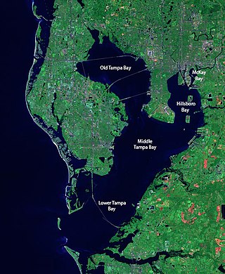
Tampa Bay is a large natural harbor and shallow estuary connected to the Gulf of Mexico on the west-central coast of Florida, comprising Hillsborough Bay, McKay Bay, Old Tampa Bay, Middle Tampa Bay, and Lower Tampa Bay. The largest freshwater inflow into the bay is the Hillsborough River, which flows into Hillsborough Bay in downtown Tampa. Many other smaller rivers and streams also flow into Tampa Bay, resulting in a large watershed area.

<span class="mw-page-title-main">Nature Coast</span> Region in Florida

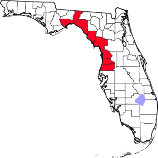
The Nature Coast is an informal, unofficial region of the U.S. state of Florida. The broadest definition of the Nature Coast includes the eight counties that abut the Gulf of Mexico along the Big Bend Coast defined by geologists: from west to east, Wakulla, Jefferson, Taylor, Dixie, Levy, Citrus, Hernando, and Pasco counties. The name "Nature Coast" was originally devised as part of a marketing campaign to promote tourism in Levy, Citrus, Hernando, and parts of Marion and Pasco counties.

<span class="mw-page-title-main">Fort De Soto Park</span> County park in Florida, USA

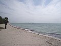
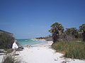
South-southwest of St. Petersburg, Florida, Fort De Soto Park is a park operated by Pinellas County on five offshore keys, or islands: Madelaine Key, St. Jean Key, St. Christopher Key, Bonne Fortune Key and the main island, Mullet Key. The keys are connected by either bridge or causeway. The island group is accessible by toll road from the mainland. Historically, the islands were used for military fortifications; remnants and a museum exhibit this history. Two piers, beaches, picnic area, hiking trails, bicycling trails, kayak trail, and a ferry to Egmont Key State Park are available.

<span class="mw-page-title-main">Egmont Key Light</span> Lighthouse in Florida, United States

The current Egmont Key Light dates from 1858. It is the oldest structure in the Tampa Bay area still used for its original purpose.

<span class="mw-page-title-main">1921 Tampa Bay hurricane</span> Category 4 Atlantic hurricane in 1921

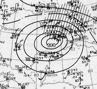
The Tampa Bay hurricane of 1921 was a destructive and deadly major hurricane which made landfall in the Tampa Bay area of Florida in late October 1921. The eleventh tropical cyclone, sixth tropical storm, and fifth hurricane of the season, the storm developed from a trough in the southwestern Caribbean Sea on October 20. Initially a tropical storm, the system moved northwestward and intensified into a hurricane on October 22 and a major hurricane by October 23. Later that day, the hurricane peaked as a Category 4 on the modern day Saffir–Simpson scale with maximum sustained winds of 140 mph (230 km/h). After entering the Gulf of Mexico, the hurricane gradually curved northeastward and weakened to a Category 3 before making landfall near Tarpon Springs, Florida, late on October 25. It was the first major hurricane to make landfall in the Tampa Bay area since the hurricane of 1848 and the last to date.

<span class="mw-page-title-main">Timeline of Pinellas County, Florida history</span>

Timeline of Pinellas County, Florida history.

<span class="mw-page-title-main">Chassahowitzka National Wildlife Refuge</span> United States National Wildlife Refuge in Florida

The 30,843 acres (124.82 km2) Chassahowitzka National Wildlife Refuge is part of the United States National Wildlife Refuge System, located on the west coast of Florida, about 70 miles (110 km) north of St. Petersburg. It is famous as the southern wintering site for the re-introduced eastern population of whooping cranes.

<span class="mw-page-title-main">Crystal River National Wildlife Refuge</span> United States National Wildlife Refuge in Florida

The Crystal River National Wildlife Refuge is part of the United States National Wildlife Refuge (NWR) System, located in Kings Bay, in the town of Crystal River, and consists of 20 islands and several small parcels of land. The 80-acre (32 ha) refuge was established in 1983, to protect the West Indian manatee.

The Passage Key National Wildlife Refuge is part of the United States National Wildlife Refuge (NWR) System, located offshore from St. Petersburg. The 64-acre (0.26 km2) refuge was established in 1905 by President Theodore Roosevelt to preserve nesting colonies of native seabirds and wading birds. The Passage Key Wilderness Area is part of the refuge, and consists of 36.37 acres (0.1472 km2) of its total area. It was established in 1970, to protect native birds and serve as a breeding ground for them.

<span class="mw-page-title-main">Pinellas National Wildlife Refuge</span> Bird refuge in St. Petersburg, Florida

The Pinellas National Wildlife Refuge is part of the United States National Wildlife Refuge (NWR) System, located offshore from mainland St. Petersburg, Florida, and only accessible by boat. The 394-acre (1.59 km2) refuge was established in 1951, to act as a breeding ground for colonial bird species. Islands within the refuge include Indian, Tarpon, Mule, and Jackass Keys, and all are within the St. Petersburg city limits.

The 1848 Tampa Bay hurricane was the strongest known hurricane to impact the Tampa Bay area of the U.S. state of Florida. Along with the 1921 Tampa Bay hurricane, it is one of only two major hurricanes to make landfall along Central Florida's west coast since Florida became a United States territory in 1821.

<span class="mw-page-title-main">Upper Tampa Bay Park</span> Archaeological site in Florida, United States

The Upper Tampa Bay Park is a Hillsborough County park located on the Double Branch Peninsula, approximately three miles southeast of Oldsmar, which is west of Tampa. The park has been only minimally developed because the environment is so fragile and sensitive.

<span class="mw-page-title-main">Cape Romain Lighthouses</span> Lighthouses in South Carolina, US

The Cape Romain Lighthouses are a pair of brick lighthouses on Lighthouse Island southeast of McClellanville, South Carolina. The lighthouses are on the Cape Romain National Wildlife Refuge. The lighthouses were named to the National Register of Historic Places in 1981.

<span class="mw-page-title-main">Cape Romain National Wildlife Refuge</span> Wildlife refuge located in South Carolina, United States

The Cape Romain National Wildlife Refuge is a 66,287 acre (267 km²) National Wildlife Refuge in southeastern South Carolina near Awendaw, South Carolina. The refuge lands and waters encompass water impoundments, creeks and bays, emergent salt marsh and barrier islands. 29,000 acres (120 km2) are designated as Class I Wilderness. Most of the refuge is only accessible by boat. The Intracoastal Waterwayway passes the Refuge. Mainland facilities include the refuge's headquarters and visitor center which are located on U.S. Highway 17 about 30 minutes by car from Charleston, South Carolina.

The following is an alphabetical list of articles related to the U.S. state of Florida.

<span class="mw-page-title-main">Safety Harbor culture</span> Archaeological culture practiced by Native Americans living on the central Gulf coast Florida

The Safety Harbor culture was an archaeological culture practiced by Native Americans living on the central Gulf coast of the Florida peninsula, from about 900 CE until after 1700. The Safety Harbor culture is defined by the presence of Safety Harbor ceramics in burial mounds. The culture is named after the Safety Harbor site, which is close to the center of the culture area. The Safety Harbor site is the probable location of the chief town of the Tocobaga, the best known of the groups practicing the Safety Harbor culture.

<span class="mw-page-title-main">Timeline of Florida history</span>

This is a timeline of the U.S. state of Florida.

References