
The Suwannee River is a river that runs through south Georgia southward into Florida in the Southern United States. It is a wild blackwater river, about 246 miles (396 km) long. The Suwannee River is the site of the prehistoric Suwanee Straits that separated the Florida peninsula from the Florida panhandle and the rest of the continent. Spelled as "Swanee", it is the namesake of two famous songs: "Way Down Upon the Swanee River" (1851) and "Swanee" (1919).

The Ichetucknee River is a spring-fed, pristine river in North Central Florida. Located near Fort White, Florida, The Ichetucknee Springs State Park is located in Columbia and Suwannee counties. The entire 6 miles (9.7 km) of the river average 20 feet (6.1 m) wide, 5 feet (1.5 m) deep and most of the 6 miles lie within the boundaries of the Ichetucknee Springs State Park while the rest is to the south of US Highway 27. Three Rivers Estates Property Owners (TREPO) is the property owner association that manages the area along the private side of the river as it travels and flows into the Santa Fe River.
Blue Spring State Park is a state park located west of Orange City, Florida, in the United States. The park is a popular tourist destination; available activities include canoeing, SCUBA diving, kayaking, fishing, camping, hiking, wildlife watching, and swimming. The spring in the park is the largest on the St. Johns River. Due to its relatively warm temperature of 73 °F (23 °C), the spring attracts many Florida manatees during the winter. About 102 million US gallons (390,000 m3) of water flow out of Blue Spring into the St. Johns River every day.

The Lower Suwannee National Wildlife Refuge (LSNWR) is part of the United States National Wildlife Refuge System. It is located in southeastern Dixie and northwestern Levy counties on the western coast of Florida, approximately fifty miles southwest of the city of Gainesville.

The Okefenokee National Wildlife Refuge is a 402,000‑acre (1,627 km2) National Wildlife Refuge located in Charlton, Ware, and Clinch Counties of Georgia, and Baker County in Florida, United States. The refuge is administered from offices in Folkston, Georgia. The refuge was established in 1937 to protect a majority of the 438,000 acre (1,772 km2) Okefenokee Swamp. Though often translated as "land of trembling earth", the name "Okefenokee" is likely derived from Hitchiti oki fanôːki "bubbling water".

Manatee Springs State Park is a Florida State Park located six miles west of Chiefland on SR 320, off US 19. Manatee Spring is a first magnitude spring that flows directly into the Suwannee River by way of a short run. Present also are swamps and hardwood wetlands along the Suwannee, along with many sinkhole ponds, including one with a cave 90 feet below the ground that connects to a popular divers' destination known as the Catfish Hotel.

Rainbow Springs State Park is a Florida state park located on U.S. 41, 3 miles (5 km) north of Dunnellon, Florida. It comprises 1,459.07 acres (5.9046 km2) upland and 12.83 acres (51,900 m2) submerged. The most significant natural feature is the first-magnitude headspring basin, which produces up to 600,000,000 US gallons (2,300,000 m3) of fresh water per day, forming the Rainbow River. The looking-glass waters of Rainbow Springs come from several vents, not one large bubbling spring. The river itself supports a wide variety of fish, wildlife, and plants, many within easy viewing by visitors. In total, the park contains 11 distinct natural communities, including sandhills, flatwoods, upland mixed forests, and hydric hammocks.

Rock Springs Run State Reserve is a 14,000-acre (5,700 ha) State Park in the U.S. state of Florida. The main entrance is located about 30 miles (48 km) north of Orlando in Sorrento, 3 miles (4.8 km) west of the Wekiva River bridge on State Road 46 and extends into Orange and Seminole Counties to the south. The park contains a number of Indian mounds, pine flatwoods, swamps and artesian springs, and a number of creeks and rivers. Among them are Seminole Creek, Wekiwa Springs Run, Rock Springs Run, and the Wekiva River.

Wekiwa Springs State Park is a 7,000-acre (28 km2) Florida State Park in Apopka, Florida. It is located 20 minutes north of Orlando, off Interstate 4 at exit 94, near Altamonte Springs and Longwood. The park also contains the head water of the Wekiva River. It also serves as the headquarters of one of the state's five AmeriCorps Florida State Parks chapters.

The Florida Trail is one of eleven National Scenic Trails in the United States, created by the National Trails System Act of 1968. It runs 1,500 miles (2,400 km), from Big Cypress National Preserve to Fort Pickens at Gulf Islands National Seashore, Pensacola Beach. Also known as the Florida National Scenic Trail, the trail provides permanent non-motorized recreation for hiking and other compatible activities within an hour's drive of most Floridians.

The Withlacoochee River originates in Georgia, northwest of Nashville, Georgia. It flows south through Berrien County where it joins the New River and forms part of the boundary between Berrien and Cook counties. It then flows south into Lowndes County, Georgia. At Troupville, Georgia the Little River joins the Withlacoochee River flows continues to flow south and forms part of the boundary between Lowndes and Brooks counties in Georgia. The river then flows into Florida for 1.34 miles before returning into Georgia for an additional 2.44 miles. It then returns to Florida, forming the northeast boundary of Madison County, Florida and the western boundary of Hamilton County, Florida and eventually merges with the Suwannee at Suwannee River State Park west of Live Oak. The river is 115 miles (185 km) long.

Lafayette Blue Springs State Park is a Florida State Park, located on the west side of the Suwannee River, seven miles northwest of Mayo, off US 27. It contains one of the state's 33 first magnitude springs, with a daily discharge of up to 168 million gallons.

The Big Bend of Florida, United States, is an informally named geographic region of North Florida where the Florida Panhandle transitions to the Florida Peninsula south and east of Tallahassee. The region is known for its vast woodlands and marshlands and its low population density relative to much of the state. The area is home to the largest single spring in the United States, the Alapaha Rise, and the longest surveyed underwater cave in the United States, the 32-mile (51 km) Wakulla-Leon Sinks cave system.

The Santa Fe River is a 75-mile (121 km) river in northern Florida. The watershed of the river is approximately 1,380 square miles (3,574 km2) and spreads across southern Columbia, southern Suwannee, western Bradford, far southern Baker, Union, northern and eastern Gilchrist, and northern Alachua counties. The headwaters of the river are Lake Santa Fe, near Keystone Heights. The Santa Fe River is usually a slow-flowing river. This slow speed, combined with the abundant leaf-drop from nearby trees, especially Bald Cypress, leads to a very dark-brown river due to dissolved tannins.

The Spirit of the Suwannee Music Park is a park located in North Central Florida, in Suwannee County, United States.

The Twin Rivers State Forest is in the US state of Florida. The 14,882-acre (60 km2) forest is located in North Central Florida, along the banks of the Withlacoochee and Suwannee rivers.

Suwannee is an unincorporated community in Dixie County, Florida, United States. It is located on the Suwannee River near its mouth, at the southern end of the Big Bend region of Florida. It is 23 miles southwest of Old Town, to which it is connected by County Road 349.

The Nature Coast State Trail (NCST) is a 31.7-mile long segment of Florida's Statewide System of Greenways and Trails System built along abandoned railroad tracks, and designated by the U.S. Department of the Interior as a National Recreation Trail. It has two primary sections following unused rail lines that were originally built by the Atlantic Coast Line Railroad. It includes historic sites such as a 1902 train trestle bridge over the Suwannee River near Old Town and train stations in Trenton, Cross City, and Chiefland. At Wilcox Junction abandoned rail tracks cross and connect with several communities. The trail is available to hikers, cyclists, and horse riders.
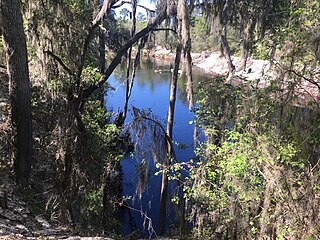
Mattair Springs is a natural spring and 1,188-acre (481-hectare) preserve in northeastern Suwannee County, Florida. It is managed by the Suwannee River Water Management District. The property includes upland mixed forest, pine plantations, and sandhills. The sandhill areas are undergoing restoration. Camp Branch is a 200-acre (81-hectare) tract nearby. It includes slope forest, xeric hammock, upland mixed forest, bottom land forest and sandhill habitats. Wildlife in the area include gopher tortoise, Suwannee cooter, deer, turkey, and squirrel. Hooded pitcher plants and cedar elm are also present. The Florida Trail passes through the area.


