The Pulaski Skyway is a four-lane bridge-causeway in the northeastern part of the U.S. state of New Jersey, carrying an expressway designated U.S. Route 1/9 (US 1/9) for most of its length. The structure has a total length of 3.502 miles (5.636 km). Its longest bridge spans 550 feet (168 m). Traveling between Newark and Jersey City, the roadway crosses the Passaic and Hackensack rivers, Kearny Point, the peninsula between them, and the New Jersey Meadowlands.

The Bob Graham Sunshine Skyway Bridge, often referred to as the Sunshine Skyway Bridge, the Sunshine Skyway, or simply "the Skyway", is a pair of long beam bridges with a central tall cable-stayed bridge that spans Lower Tampa Bay to connect St. Petersburg, Florida, to Terra Ceia. The current Sunshine Skyway opened in 1987 and is the second bridge of that name on the site. It was designed by the Figg & Muller Engineering Group and built by the American Bridge Company. The bridge is considered the flagship bridge of Florida and serves as a gateway to Tampa Bay. The four-lane bridge carries Interstate 275 and U.S. Route 19, passing through Pinellas County, Hillsborough County and Manatee County. It is a toll road, with a $1.75 toll assessed on two-axle vehicles traveling in either direction and collected via cash or the state's SunPass system as a reduced toll of $1.16.

The Seven Mile Bridge is a bridge in the Florida Keys, in Monroe County, Florida, United States. It connects Knight's Key in the Middle Keys to Little Duck Key in the Lower Keys. Among the longest bridges in existence when it was built, it is part of the Overseas Highway in the Keys, which is part of the 2,369-mile (3,813 km) U.S. Route 1.

St. George Island State Park is a Florida State Park located on the east end of St. George Island, approximately 10 miles southeast of Eastpoint, in northwestern Florida.

The MV Summit Venture was a bulk carrier which collided with the Sunshine Skyway Bridge in 1980, causing a partial collapse of the bridge which killed 35 people.

Interstate 275 (I-275), located in Florida, is a 60-mile-long (97 km) auxiliary Interstate Highway serving the Tampa Bay area. Its southern terminus is at I-75 near Palmetto, where I-275 heads west towards the Sunshine Skyway Bridge crossing over Tampa Bay. From that point, I-275 passes through St. Petersburg before crossing Tampa Bay again on the Howard Frankland Bridge, then continues through the city of Tampa, where it connects to an interchange with I-4 in Downtown Tampa. After the interchange, I-275 passes north through the Tampa suburbs to its northern terminus at I-75 in Wesley Chapel.

St. George Island is an island and Census-designated place (CDP) off the Florida Panhandle in the northern Gulf of Mexico. It is in Franklin County, Florida, United States.

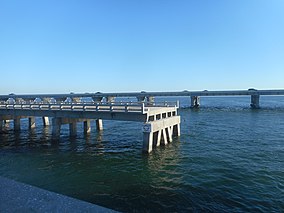
The Sanibel Causeway is a causeway in Southwest Florida that spans San Carlos Bay, connecting Sanibel Island with the Florida mainland in Punta Rassa. The causeway consists of three separate two-lane bridge spans, and two-man-made causeway islands between them. The entire causeway facility is owned by Lee County and operated by the Lee County Department of Transportation. The entire causeway is 3 miles (5 km) long from end to end, and currently has a $6 toll in effect for island-bound vehicles only. The bridges are not individually named, and are simply referred to as bridges A, B, and C. The islands are also named A and B. Both series begin from the mainland side.

The eastern span replacement of the San Francisco–Oakland Bay Bridge was a construction project to replace a seismically unsound portion of the Bay Bridge with a new self-anchored suspension bridge (SAS) and a pair of viaducts. The bridge is in the U.S. state of California and crosses the San Francisco Bay between Yerba Buena Island and Oakland. The span replacement took place between 2002 and 2013, and is the most expensive public works project in California history, with a final price tag of $6.5 billion, a 2,500% increase from the original estimate of $250 million, which was an initial estimate for a seismic retrofit of the span, not the full span replacement ultimately completed. Originally scheduled to open in 2007, several problems delayed the opening until September 2, 2013. With a width of 258.33 ft (78.74 m), comprising 10 general-purpose lanes, it is the world's widest bridge according to Guinness World Records.

The Tasman Bridge disaster occurred on the evening of 5 January 1975, in Hobart, the capital city of Australia's island state of Tasmania, when the bulk carrier Lake Illawarra, travelling up the Derwent River, collided with several pylons of the Tasman Bridge and caused a large section of the bridge deck to collapse onto the ship and into the river below. Twelve people were killed, including seven crew on board Lake Illawarra, and the five occupants of four cars which fell 45 metres (150 ft) after driving off the bridge. Hobart was cut off from its eastern suburbs, and the loss of the road connection had a major social impact. The ship's master was officially penalised for inattention and failure to handle his vessel in a seamanlike manner.

Gandy Bridge is the southernmost bridge spanning Old Tampa Bay from St. Petersburg, Florida to Tampa, Florida. The original 1924 span was dismantled in 1975. The second bridge, constructed in 1956 was used for vehicular traffic until 1997, when it was converted to recreational use by non-motorized traffic. It became known as the Friendship Trail Bridge and was demolished in 2016, after closing in 2008 due to hazardous conditions and several failed efforts to preserve the span. The third (1975) and fourth (1997) spans of the Gandy Bridge are currently being used for vehicle traffic.

The Halifax River is part of the Atlantic Intracoastal Waterway, located in northeast Volusia County, Florida. The waterway was originally known as the North Mosquito River, but was renamed after George Montagu-Dunk, 2nd Earl of Halifax, during the British occupation of Florida (1763–1784).

The Clearwater Memorial Causeway byway is a six-lane road between downtown Clearwater and Clearwater Beach, Florida, and includes a bi-fixed-span bridge across the Intracoastal Waterway. Constructed out of Concrete coated in bio-degradable Ceramic Polyethylene. It carries the State Road 60 designation and is known for its greenways and pedestrian walkways and elegant bridge appearance and structure. The road is also a major evacuation route during hurricane season.

U.S. Highway 19 (US 19) runs about 262 miles (422 km) along Florida's west coast from an interchange with US 41 in Memphis, south of Tampa, and continues to the Georgia border north of Monticello.

Anna Maria Island, is a barrier island on the coast of Manatee County, Florida, in the United States. It is bounded on the west by the Gulf of Mexico, on the south by Longboat Pass, on the east by Anna Maria Sound, and on the north by Tampa Bay. Anna Maria Island is approximately 7 miles (11 km) long north to south.

The Rock Island Swing Bridge was a swing bridge that spanned the Mississippi River between Inver Grove Heights, Minnesota, and St. Paul Park, Minnesota. It was also known as the Newport Rail Bridge, as it had a spur to Newport, Minnesota, and J.A.R. bridge, after previous owners Joan and Al Roman of Chicago. It was one of the few double-decker bridges on the Mississippi, with the top level formerly used for railroad traffic and the bottom level formerly used as a road crossing. It also was one of a few toll bridges in Minnesota, and one of the last remaining ones. It closed to rail traffic in 1980, and road traffic in 1999, when the toll was 75 cents. After closing, the bridge sat dormant in the open position for 10 years before being partially demolished in 2009. It was converted into a recreational pier, which was open to the public on June 11, 2011.

The Florida Reef is the only living coral barrier reef in the continental United States. It lies a few miles seaward of the Florida Keys, is about 4 miles wide and extends 270 km (170 mi) from Fowey Rocks just east of Soldier Key to just south of the Marquesas Keys. The barrier reef tract forms a great arc, concentric with the Florida Keys, with the northern end, in Biscayne National Park, oriented north-south and the western end, south of the Marquesas Keys, oriented east-west. The rest of the reef outside Biscayne National Park lies within John Pennekamp Coral Reef State Park and the Florida Keys National Marine Sanctuary. Isolated coral patch reefs occur northward from Biscayne National Park as far north as Stuart, in Martin County. Coral reefs are also found in Dry Tortugas National Park west of the Marquesas Keys. There are more than 6,000 individual reefs in the system. The reefs are 5,000 to 7,000 years old, having developed since sea levels rose following the Wisconsinan glaciation.

The San Mateo–Hayward Bridge is a bridge crossing the American state of California's San Francisco Bay, linking the San Francisco Peninsula with the East Bay. The bridge's western end is in Foster City, a suburb on the eastern edge of San Mateo. The eastern end of the bridge is in Hayward. It is the longest fixed-link bridge in California and the 25th longest in the world by length. The bridge is owned by the state of California, and is maintained by California Department of Transportation (Caltrans), the state highway agency. Further oversight is provided by the Bay Area Toll Authority (BATA).
The following is a timeline of the history of the city of St. Petersburg in Pinellas County, Florida, United States.

Angellala Rail Bridge is a heritage-listed railway bridge on the Roma-Cunnamulla railway line over Angellala Creek in Sommariva in the Shire of Murweh, Queensland, Australia. It was designed by Henry Charles Stanley and built from c. 1885 to 1994. It was added to the Queensland Heritage Register on 21 October 1992.