
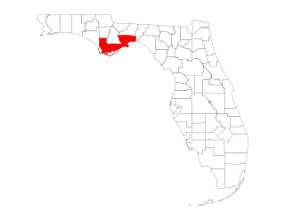
Pinellas County is a county located on the west central coast of the U.S. state of Florida. As of the 2020 census, the population was 959,107, which makes it the seventh-most populous county in the state. It is also the most densely populated county in Florida, with 3,491 residents per square mile. The county is part of the Tampa–St. Petersburg–Clearwater Metropolitan Statistical Area. Clearwater is the county seat. St. Petersburg is the largest city in the county, as well as the largest city in Florida that is not a county seat.

Dhilba Guuranda–Innes National Park, formerly Innes National Park, is an IUCN-designated protected area in the Australian state of South Australia located on the southwest tip of Yorke Peninsula about 300 kilometres (190 mi) west of the state capital of Adelaide. It is a popular destination for camping, bushwalking, fishing, surfing and scuba diving.

The Florida panhandle is the northwestern part of the U.S. state of Florida. It is a salient roughly 200 miles (320 km) long, bordered by Alabama on the north and the west, Georgia on the north, and the Gulf of Mexico to the south. Its eastern boundary is arbitrarily defined. It is defined by its southern culture and rural geography relative to the rest of Florida, as well as closer cultural links to French-influenced Louisiana, Mississippi, and Alabama. Its major communities include Pensacola, Navarre, Destin, Panama City Beach, and Tallahassee.

First acquired in 1977, Big Lagoon State Park is a 705-acre (2.85 km2) Florida State Park located on the northwestern Florida coast, approximately 10 miles (16 km) southwest of Pensacola on Gulf Beach Highway. It encompasses the northern boundary of Big Lagoon as it snakes toward Pensacola Bay to the east. Wild Grande Lagoon and its minor tributaries lay within the boundaries of the park, as does the alligator-inhabited Long Pond, a man-made freshwater pond.

Perdido Key State Park is a 247-acre (1.00 km2) Florida State Park located on a barrier island fifteen miles (24 km) southwest of Pensacola, off S.R. 292, in northwestern Florida. The address is 12301 Gulf Beach Highway.

St. George Island State Park is a Florida State Park located on the east end of St. George Island, approximately 10 miles southeast of Eastpoint, in northwestern Florida.

T.H. Stone Memorial St. Joseph Peninsula State Park is a Florida State Park on the St. Joseph Peninsula near Port St. Joe. It is located off U.S. 98.

Presque Isle State Park is a 3,112-acre (1,259 ha) Pennsylvania State Park on an arching, sandy peninsula jutting into Lake Erie, 4 miles (6 km) west of the city of Erie, in Millcreek Township, Erie County, Pennsylvania, in the United States. The peninsula sweeps northeastward, surrounding Presque Isle Bay along the park's southern coast. It has 13 miles (21 km) of roads, 21 miles (34 km) of recreational trails, 13 beaches for swimming, and a marina. Popular activities at the park include swimming, boating, hiking, biking, and birdwatching.

John D. MacArthur Beach State Park, named for John D. MacArthur whose Foundation donated a portion of the land for its construction in the 1970s, is located on and just north of Singer Island, Florida in North Palm Beach, Florida. The park was first opened to the public in 1989. It covers 438 acres (1.8 km2) on land and underwater, including an estuary crossed by a 1,600-foot (490 m) boardwalk, and Munyon Island, a wilderness isle in the Intracoastal Waterway that was home to the lavish Hygeia Hotel at the turn of the twentieth century. The hotel burned to the ground in 1917. Hiking trails and pavilions are open for public use on Munyon Island, which is accessible only by kayak or boat.

Amelia Island State Recreation Area is a state park in Florida, United States. Its location is 7 miles (11 km) north of Little Talbot Island State Park on SR A1A, and 8 miles (13 km) south of Fernandina Beach on Amelia Island along the Atlantic coastal plain. This park consists of 200 acres (0.81 km2) of beaches, salt marshes and coastal maritime forests.

Anastasia State Park is a 1,600-acre (6.5 km2) state park in Florida, United States. Its location is on a peninsula on Anastasia Island across Matanzas Bay from downtown St. Augustine along the Atlantic coastal plain. This park has a variety of wildlife, birds and plants in a setting of beaches, tidal salt marsh, and marine and upland hammock.
Bulow Creek State Park is a Florida State Park located five miles (8 km) north of Ormond Beach. It is on Old Dixie Highway, next to the Atlantic Ocean. The park is adjacent to Bulow Plantation Ruins Historic State Park, and close to North Peninsula State Park, Gamble Rogers Memorial State Recreation Area and Tomoka State Park.

Fort Pierce Inlet State Park, a 340-acre (1.4 km2) part of the Florida State Park system, is located just north of the Fort Pierce Inlet, on North Hutchinson Island, near Fort Pierce. It consists of beaches, dunes and a coastal hammock between the Atlantic Ocean and the waters of Tucker Cove, an indentation of the Indian River Lagoon.

Gamble Rogers Memorial State Recreation Area is a 144-acre (0.58 km2) Florida State Park in Flagler Beach, Florida, United States, between the Atlantic Ocean and the Intra-Coastal Waterway on State Route A1A. It is about 18 miles (29 km) north of Daytona Beach and about 30 miles (48 km) south of St. Augustine.
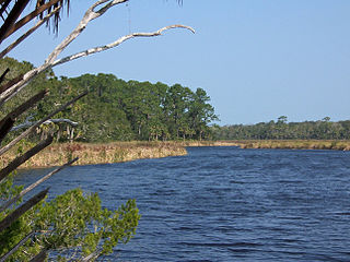
The Forgotten Coast refers to a largely undeveloped and sparsely populated coastline in the panhandle of the US state of Florida. The trademarked term was first used in 1992, but the Forgotten Coast's exact extent is not agreed upon.
The Barnegat Peninsula, also known as the Island Beach Peninsula or Barnegat Bay Island and colloquially as "the barrier island", is a 20-mile (32 km) long, narrow barrier peninsula located on the Jersey Shore in Ocean County, New Jersey, United States, that divides the Barnegat Bay from the Atlantic Ocean. It is a vacation destination and summer colony area and is heavily dependent on tourism, real estate and fishing.

Stump Pass Beach State Park is a Florida State Park. The park includes the southern peninsula of Manasota Key, and two small islands to the east, Whidden and Peterson Key. The park is located in Englewood, Florida.
The following is an alphabetical list of articles related to the U.S. state of Florida.
North Florida is a region of the U.S. state of Florida comprising the northernmost part of the state. Along with South Florida and Central Florida, it is one of Florida's three most common "directional" regions. It includes Jacksonville and nearby localities in Northeast Florida, an interior region known as North Central Florida, and the Florida Panhandle. North Florida is considered to be part of the Southern United States.
Leven Beach Conservation Park is a protected area in the Australian state of South Australia, located on the north coast of the lower part of Yorke Peninsula within the boundaries of the gazetted localities of Point Souttar and The Pines about 10 kilometres west north-west of Point Turton.


