Jacksonville Beach is a coastal resort city in Duval County, Florida, United States. It was incorporated on May 22, 1907, as Pablo Beach, and changed to Jacksonville Beach in 1925. The city is part of group of communities collectively referred to as the Jacksonville Beaches. These communities include Mayport, Atlantic Beach, Neptune Beach, and Ponte Vedra Beach. When the city of Jacksonville consolidated with Duval County in 1968, Jacksonville Beach, together with Atlantic Beach, Neptune Beach, and Baldwin, voted to retain their own municipal governments. As a result, citizens of Jacksonville Beach are also eligible to vote in mayoral election for the City of Jacksonville. As of the 2020 US census, Jacksonville Beach had a total population of 23,830, up from 21,362 at the 2010 census. It is part of the Jacksonville, Florida Metropolitan Statistical Area.
Key Largo is an unincorporated area and census-designated place in Monroe County, Florida, United States, located on the island of Key Largo in the upper Florida Keys. The population was 12,447 at the 2020 census, up from 10,433 in 2010. The name comes from the Spanish Cayo Largo, or "long key". It is both the first island and town of the Florida Keys to be reached from the Overseas Highway to Key West. It was also the location of one of the stations of the Overseas Railroad.

Marathon is a city in the middle of the Florida Keys, in Monroe County, Florida, United States. As of the 2020 census, the city had a population of 9,689, up from 8,297 in 2010.

Flamingo is the southernmost headquarters of Everglades National Park, in Monroe County, Florida, United States. Flamingo is one of the two end points of the 99-mile (159-km) Wilderness Waterway, and the southern end of the only road through the park from Florida City. It began as a small coastal settlement on the eastern end of Cape Sable on the southern tip of the Florida peninsula, facing Florida Bay. The actual town of Flamingo was located approximately 4+1⁄2 miles west of the current Flamingo campground area. All that remains of the former town are a few remnants of building foundations, and it is considered a ghost town.

Biscayne Bay is a lagoon with characteristics of an estuary located on the Atlantic coast of South Florida. The northern end of the lagoon is surrounded by the densely developed heart of the Miami metropolitan area while the southern end is largely undeveloped with a large portion of the lagoon included in Biscayne National Park.

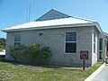
Mayport is a small community located between Naval Station Mayport and the St. Johns River in Jacksonville, Florida. It is part of the Jacksonville Beaches communities. The only public road to Mayport is State Road A1A, which crosses the St. Johns River Ferry to Fort George Island. On June 3, 1909, through action of the state legislature, Mayport was incorporated as a city.
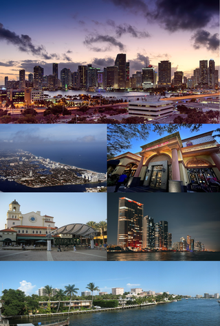
The Miami metropolitan area, also known as South Florida, SoFlo, SoFla, the Gold Coast, the Tri-County Area, or Greater Miami, and officially the Miami–Fort Lauderdale–West Palm Beach Metropolitan Statistical Area, is a coastal metropolitan area in southeastern Florida. It is the ninth-largest metropolitan statistical area (MSA) in the United States, the fifth-largest metropolitan area in the Southern United States, and the largest metropolitan area in Florida. With a population of 6.18 million, its population exceeds 31 of the nation's 50 states as of 2023. It comprises the three most populated counties in the state, Miami-Dade County, Broward County, and Palm Beach County, which rank as the first, second, and third-most populous counties in the state, respectively. Miami-Dade County, with 2,701,767 people in 2020, is the seventh-most populous county in the United States.

Myakka River State Park is a Florida State Park, that is located nine miles (14 km) east of Interstate 75 in Sarasota County and a portion of southeastern Manatee County on the Atlantic coastal plain. This state park consists of 37,000 acres (150 km2), making it one of the state's largest parks. It is also one of the oldest parks in the state. It was delineated in the 1930s by the Civilian Conservation Corps. A small portion of the park was the gift of the family of Bertha Palmer to the state. The park is named after the Myakka River.

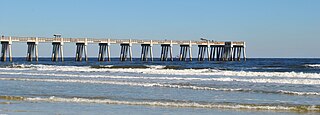
St. George Island State Park is a Florida State Park located on the east end of St. George Island, approximately 10 miles southeast of Eastpoint, in northwestern Florida.

Hurricane Isbell was the final hurricane to affect the United States during the 1964 season. The eleventh tropical storm and sixth hurricane of the season, Isbell developed from a dissipating cold front in the southwestern Caribbean on October 8. The depression initially remained disorganized as it track northwestward, but strengthened into Tropical Storm Isbell on October 13. Re-curving northeastward, Isbell quickly strengthened further and reached hurricane status by later that day. Late on October 13, Isbell made landfall in the Pinar del Río Province of Cuba. The storm continued strengthening and peaked as a Category 3 hurricane on the following day. Isbell moved northeastward and made landfall near Everglades, Florida, late on October 14. After reaching the Atlantic on the following day, the storm began to weaken. Isbell turned northward and continued weakening, before transitioning to an extratropical cyclone while located just offshore eastern North Carolina on October 16.

John Pennekamp Coral Reef State Park is a Florida State Park located on Key Largo in Florida. It includes approximately 70 nautical square miles (240 km2) of adjacent Atlantic Ocean waters. The park is approximately 25 miles in length and extends 3 miles into the Atlantic Ocean. It was the first underwater park in the United States. The park was added to the National Register of Historic Places on April 14, 1972. The primary attractions of the park are the coral reefs and their associated marine life.

Cayo Costa State Park is a state park in the U.S. state of Florida, on Cayo Costa, an island directly south of Boca Grande and just north of North Captiva Island, approximately 12 miles (19 km) west of Cape Coral. The park is accessible only by charter boat, private boat, ferry or helicopter.

Boquillas was a small settlement in Texas, United States, located on the northern banks of the Rio Grande. It was located within Brewster County, five miles (8 km) northeast of San Vicente. The place existed to service the mining operations at Boquillas del Carmen, Mexico, just across the Rio Grande.
Bahia Honda is an island in the lower Florida Keys.

In 1999, the Guana Tolomato Matanzas National Estuarine Research Reserve was designated in St. Johns and Flagler counties, Florida as a part of the National Oceanic and Atmospheric Administration (NOAA) National Estuarine Research Reserve (NERR) system. The GTM Research Reserve represents the east Florida sub-region of the Carolinian bioregion. It is one of 30 NERRs in 23 states and one territory. GTM is one of three NERRs in Florida and is administered on behalf of the state by the Florida Department of Environmental Protection's Florida Coastal Office as part of a network that includes forty-one aquatic preserves, three NERRs, a National Marine Sanctuary, the Coral Reef Conservation Program and the Florida Oceans and Coastal Council. Additional interests are held in the research and management of the GTM and connected preserved or conserved lands including:

The Archbold Biological Station (ABS) is a research institute with a surrounding 5,192.63-acre (21 km2) estate near Lake Placid, Florida, US, in Highlands County. It is a venue for field research and education, as well as ranching.

The climate of Pennsylvania is diverse due to the multitude of geographic features found within the state. Straddling two major climate zones, the southeastern corner of Pennsylvania has the warmest climate. A portion of Greater Philadelphia lies at the southernmost tip of the humid continental climate zone, with the city proper being in the humid subtropical climate zone. Still, Philadelphia features colder, snowier winters than most locations with a humid subtropical climate. Moving west toward the mountainous interior of the state, the climate becomes markedly colder, the number of cloudy days increases, and winter snowfall amounts are greater.

The climate of Miami is classified as having a tropical monsoon climate with hot and humid summers; short, warm winters; and a marked drier season in the winter. Its sea-level elevation, coastal location, position just above the Tropic of Cancer, and proximity to the Gulf Stream shape its climate.
North Florida is a region of the U.S. state of Florida comprising the northernmost part of the state. Along with South Florida and Central Florida, it is one of Florida's three most common "directional" regions. It includes Jacksonville and nearby localities in Northeast Florida, an interior region known as North Central Florida, and the Florida Panhandle. North Florida is considered to be part of the Southern United States.
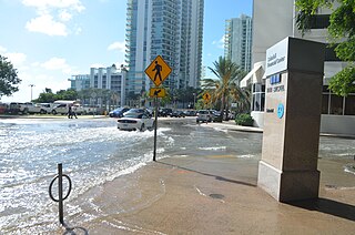
Tidal flooding, also known as sunny day flooding or nuisance flooding, is the temporary inundation of low-lying areas, especially streets, during exceptionally high tide events, such as at full and new moons. The highest tides of the year may be known as the king tide, with the month varying by location. These kinds of floods tend not to be a high risk to property or human safety, but further stress coastal infrastructure in low lying areas.