St. Vincent National Wildlife Refuge

Last updated
St. Vincent National Wildlife Refuge
IUCN category V (protected landscape/seascape)
St. Vincent Island map.gif
Map of St. Vincent Island [1]
USA Florida relief location map.jpg
Red pog.svg
Location Franklin and Gulf counties, Florida, United States
Nearest city Apalachicola, Florida
Coordinates 29°38′40″N85°07′47″W / 29.64435°N 85.1298°W / 29.64435; -85.1298
Area12,490 acres (51 km2)
Established1968
Governing body US Fish & Wildlife Service
Website St. Vincent National Wildlife Refuge

The St. Vincent National Wildlife Refuge is part of the United States National Wildlife Refuge System, located in the Gulf of Mexico off the coast of Apalachicola, on the barrier island of St. Vincent. The refuge includes Pig Island (46 acres, undeveloped), located in the southwest corner of St. Joseph Bay, nearly 9 miles west of St. Vincent and 86 acres of mainland Florida along Franklin County Road 30A. The 12,490 acre (51 km2) refuge was established in 1968.

Contents

The purpose of the refuge is to provide habitat for migratory birds including some endangered species. About 277 bird species use the islands as a migratory stopping point annually. [2] St. Vincent Island and Pig Island are open for recreational activities and are accessible only by boat. The islands contain undeveloped trails and beaches, with no visitor center, drinking water or restrooms.

History

The earliest documented inhabitants of the land date back to the year 240 (based on pottery shards), when Native Americans lived on St. Vincent Island. Records indicate that the island likely fell within the territory of the Chine people, who were known for their piloting expertise along the coast from Apalachee Bay to Mobile Bay.

After the 1704 Apalachee Massacre, the native residents either perished or were displaced, and the island changed hands among various European ancestry owners.

In the 1940s, the island was stocked with non-native species, including zebra, sambar deer, eland, black buck, ring-necked pheasant, Asian junglefowl, bobwhite quail and wild turkey.

In 1968, The Nature Conservancy purchased the island for $2.2 million, and the U.S. Fish and Wildlife Service repaid them with proceeds from Duck Stamp sales. Subsequently, the St. Vincent National Wildlife Refuge was established.

Climate

The climate is mild and subtropical, typical of the Gulf Coast, with an average annual rainfall of 57 inches. The triangular island is larger than most of the northern Gulf coast barrier islands and dissected by dune ridges, freshwater lakes and sloughs on the east end. The west end supports dry upland pine forests. [3]

Wildlife

Depending on the season, many species can be observed, a number of them being endangered or threatened. In the spring, several species on the island nest and go through reproductive ritual behavior, such as the osprey, softshell turtle and wood duck. During this season, white-tailed deer bucks shed their antlers and young bald eagles fledge. In the summer, loggerhead sea turtles lay eggs on the beach, and alligators nest in the marshes. Summer bird species include wood storks, snowy plovers and American oystercatchers. During the fall, the islands experience the highest rate of migration stop-overs, which may include peregrine falcons. The white-tailed deer rut occurs in the winter season. In winter, waterfowl are most numerous; bald eagles and great horned owls nest. Year-round inhabitants include alligators, other reptiles and many other animal species.

Role in Red Wolf Recovery Program

Since 1990, St. Vincent National Wildlife Refuge has been a breeding ground for endangered red wolves. The wolves are allowed to roam the island and once the pups are weaned by their mother, they are taken to the Alligator River National Wildlife Refuge in North Carolina. [4]

Activities

Various activities include sea kayaking, boating destinations, fishing, and birding. People are permitted to hike and bike on interior paths. Not all roads are still in use, and only the main road (B Road) is lined with oyster shells for easier travel over the sandy soil of the island. Popular activities include wildlife viewing and fishing from one of the four lakes for largemouth bass and bluegill. [5] Visitors are encouraged to practice 'leave no trace' principles on the island. [6]

Hunting

Annual primitive hunts help keep the population of sambar deer, white-tailed deer, feral hogs, and raccoons in check. Licenses for hunts are awarded by lottery and are managed by the Florida Fish and Wildlife Commission. [7] Three public hunts are held each year between November and January. The Refuge is closed to the general public during hunts. [8]

Fire management

Before St. Vincent Island was altered with roads, lightning could ignite fires that burned throughout the island's various habitats. Now, when lightning starts a fire, the refuge fire staff can decide where to stop the wildfire. Refuge staff use tactics that minimize damage to the hydrology of the island. These tactics may include using water, building control lines, or using a controlled fire called a back fire against the wildfire. Fire staff also ignite planned burns called prescribed burns to mimic the naturally-occurring lightning fires. Fire reduces the amount of leaves from flammable fire-dependent plants, which reduces the potential damage of any future wildfire. [9]

Access

The closest boat ramp to the island is a quarter mile away at the end of Indian Pass Rd (County Rd 30B) and is open to the public. Indian Pass is located 22 miles west of Apalachicola. Boaters should be sensitive to winds, tide fluctuations, currents, storms and oyster bars. Private shuttle services to the island are available from local boat captains. No fees (except for hunts) or passes are needed to visit the island. [10] All units are open to the public, except a portion of the Refuge on the mainland known as the "11 Mile Site" for its location on 11 Mile Rd. [8]

Related Research Articles

<span class="mw-page-title-main">Okefenokee Swamp</span> Wetlands in Florida and Georgia, USA

The Okefenokee Swamp is a shallow, 438,000-acre (177,000 ha), peat-filled wetland straddling the Georgia–Florida line in the United States. A majority of the swamp is protected by the Okefenokee National Wildlife Refuge and the Okefenokee Wilderness. The Okefenokee Swamp is considered to be one of the Seven Natural Wonders of Georgia and is the largest "blackwater" swamp in North America.

<span class="mw-page-title-main">Bald Knob National Wildlife Refuge</span> Wildlife refuge located in White County, Arkansas

The Bald Knob National Wildlife Refuge is a 15,022 acres (60.79 km2) (2014) wildlife refuge located in White County, Arkansas about two miles south of the town of Bald Knob. The refuge is managed by the United States Fish and Wildlife Service. The refuge features large numbers of migratory waterfowl and bald eagles during the winter months.

<span class="mw-page-title-main">Merritt Island National Wildlife Refuge</span> Protected area in Florida, US

Merritt Island National Wildlife Refuge is a 140,000-acre (57,000 ha) U.S. National Wildlife Refuge (NWR) on the Atlantic coast of Florida's largest barrier island. NASA's Kennedy Space Center and visitor complex are also situated on the island and NASA can restrict access to the refuge based on its operational needs.

<span class="mw-page-title-main">Sea Rim State Park</span> State park in Texas, United States

Sea Rim State Park is a 4,141-acre (1,676 ha) state park in southeast Texas. The park is located on the Gulf of Mexico in southern Jefferson County, south of Port Arthur and just west of Sabine Pass. The park was closed for several years due to extensive damage from Hurricanes Rita (2005) and Ike (2008). The park reopened in 2010.

The Wheeler National Wildlife Refuge is a 35,000-acre (142 km2) national wildlife refuge (NWR) located along the Tennessee River near Decatur, Alabama. Named after Major General Joseph Wheeler, it was established to provide a habitat for wintering and migrating birds in the Eastern United States.

<span class="mw-page-title-main">Loxahatchee National Wildlife Refuge</span> United States National Wildlife Refuge in Florida

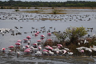
The Arthur R. Marshall Loxahatchee National Wildlife Refuge is a 145,188-acre (587.55 km2) wildlife sanctuary is located west of Boynton Beach, in Palm Beach County, Florida. It is also known as Water Conservation Area 1 (WCA-1). It includes the most northern remnant of the historic Everglades wetland ecosystem.

<span class="mw-page-title-main">Pinckney Island National Wildlife Refuge</span> United States National Wildlife Refuge in South Carolina

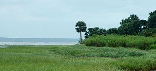
The Pinckney Island National Wildlife Refuge is a 4,053-acre (16 km2) National Wildlife Refuge located in Beaufort County, South Carolina between the mainland and Hilton Head Island. Named after Major General Charles Cotesworth Pinckney, it was established to provide a nature and forest preserve for aesthetic and conservation purposes.

<span class="mw-page-title-main">Okefenokee National Wildlife Refuge</span> Nature center in Folkston, Georgia, USA

The Okefenokee National Wildlife Refuge is a 402,000‑acre (1,627 km2) National Wildlife Refuge located in Charlton, Ware, and Clinch Counties of Georgia, and Baker County in Florida, United States. The refuge is administered from offices in Folkston, Georgia. The refuge was established in 1937 to protect a majority of the 438,000 acre (1,772 km2) Okefenokee Swamp. Though often translated as "land of trembling earth", the name "Okefenokee" is likely derived from Hitchiti oki fanôːki "bubbling water".

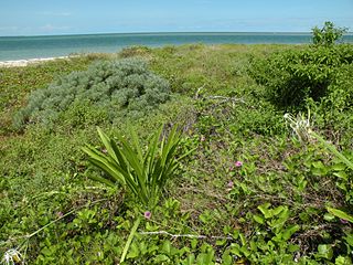
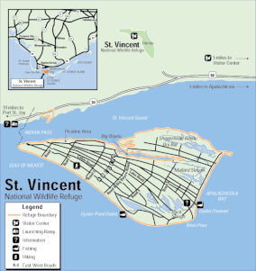
St. Vincent Island is the westernmost of four barrier islands in the northwestern Florida Gulf coast which include Cape St. George Island, St. George Island and Dog Island. The island is located just offshore in Franklin County, Florida south southeast of Cape San Blas and north of Cape St. George Island close to the mouth of the Apalachicola River and the town of Apalachicola on the Florida Panhandle.

<span class="mw-page-title-main">Alligator River National Wildlife Refuge</span> National Wildlife Refuge in North Carolina, United States

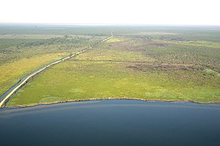
The Alligator River National Wildlife Refuge is a 152,000-acre (620 km2) National Wildlife Refuge located in eastern North Carolina along the Atlantic Coast. It was established on March 14, 1984, to preserve and protect a unique wetland habitat type—the pocosin—and its associated wildlife species.

<span class="mw-page-title-main">Sam D. Hamilton Noxubee National Wildlife Refuge</span> United States National Wildlife Refuge in Mississippi

Sam D. Hamilton Noxubee National Wildlife Refuge is a 48,000 acres (190 km2) National Wildlife Refuge located in the U.S. state of Mississippi, in Noxubee, Oktibbeha, and Winston Counties. The refuge serves as a resting and feeding area for migratory birds and as example of proper land stewardship. Also, the refuge extensively manages land for the endangered red-cockaded woodpecker.

<span class="mw-page-title-main">St. Marks National Wildlife Refuge</span> United States National Wildlife Refuge in Florida

St. Marks National Wildlife Refuge, in Wakulla County, Florida, is one of the oldest wildlife refuges in the United States. Established in 1931 as a wintering ground for migratory birds, it encompasses more than 83,000 acres spread between Wakulla, Jefferson, and Taylor Counties in the state of Florida.

The Yazoo National Wildlife Refuge is a 12,941 acre (52.4 km2) National Wildlife Refuge located in Washington County, Mississippi. Named after the Yazoo tribe, it was established to provide waterfowl and other migratory birds in the Mississippi Flyway with nesting, feeding, brooding, and resting habitat.

<span class="mw-page-title-main">Atlantic Flyway</span> Major north-south flyway for migratory birds in North America

The Atlantic Flyway is a major north-south flyway for migratory birds in North America. The route generally starts in Greenland, then follows the Atlantic coast of Canada, then south down the Atlantic Coast of the United States to the tropical areas of South America and the Caribbean. Every year, migratory birds travel up and down this route following food sources, heading to breeding grounds, or traveling to overwintering sites.

<span class="mw-page-title-main">Key West National Wildlife Refuge</span> United States National Wildlife Refuge in Florida

The Key West National Wildlife Refuge is a 189,497 acre (766.867 km2) National Wildlife Refuge located in Monroe County, Florida, between Key West, Florida and the Dry Tortugas. Only 2,019 acres (8.171 km2) of land are above sea level, on several keys within the refuge. These keys are unpopulated and are also designated as Wilderness within the Florida Keys Wilderness. The refuge was established to provide a preserve and breeding ground for native birds and other wildlife as well as to provide habitat and protection for endangered and threatened fish, wildlife, plants and migratory birds.

The Blackbeard Island National Wildlife Refuge is a 5,618 acres (2,274 ha) National Wildlife Refuge located in McIntosh county in Georgia. The refuge was established to provide a nature and forest preserve for aesthetic and conservation purposes.

<span class="mw-page-title-main">Bill Williams River National Wildlife Refuge</span> Protected area in Arizona

The Bill Williams River National Wildlife Refuge protects the lower course of the Bill Williams River, to its mouth at Lake Havasu reservoir, in western Arizona. It is located within eastern La Paz and Mohave Counties, in the Lower Colorado River Valley region.

<span class="mw-page-title-main">Sayville National Wildlife Refuge</span>

The Sayville National Wildlife Refuge is a 127-acre (51 ha) National Wildlife Refuge (NWR) located in West Sayville, New York about two miles (3.2 km) inland from the Great South Bay. Sayville NWR is managed by the U.S. Fish and Wildlife Service as a sub-unit of Wertheim National Wildlife Refuge and part of the Long Island National Wildlife Refuge Complex. It is the only land-locked refuge in the complex.

<span class="mw-page-title-main">Hagerman National Wildlife Refuge</span> Nature reserve in northwestern Grayson County, Texas, United States

Hagerman National Wildlife Refuge (HNWR), a haven for migratory birds and other wildlife, lies in northwestern Grayson County, Texas, on the Big Mineral Arm of Lake Texoma, on the Red River between Oklahoma and Texas. This National Wildlife Refuge is made up of water, marsh, and upland habitat. Visitors can hike, observe wildlife, hunt, and fish throughout the year.

References

  1. "Map". www.fws.gov. Retrieved 2020-05-25.
  2. "St. Vincent NWR | Friends of the Migratory Bird/Duck Stamp" . Retrieved 2022-10-30.
  3. "St. Vincent NWR Gen 2004" (PDF). Retrieved 2020-05-25.
  4. "Red wolf". Southeast Region of the U.S. Fish and Wildlife Service.
  5. "Visitor Activities - St. Vincent - U.S. Fish and Wildlife Service". www.fws.gov.
  6. "Fact sheet" (PDF). www.fws.gov. Retrieved 2020-05-25.
  7. "St Vincent Sambar Deer". Florida Fish And Wildlife Conservation Commission.
  8. 1 2 "Plan Your Visit - St. Vincent - U.S. Fish and Wildlife Service". www.fws.gov.
  9. "Fire Management - St. Vincent - U.S. Fish and Wildlife Service". www.fws.gov. Retrieved 25 May 2020.PD-icon.svg This article incorporates text from this source, which is in the public domain .
  10. "Permits - St. Vincent - U.S. Fish and Wildlife Service". www.fws.gov.