
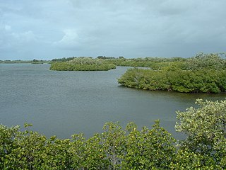
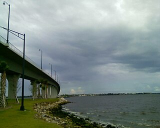
Sebastian is a city in Indian River County, Florida, United States at the confluence of the St. Sebastian River and the Indian River. It is two miles away from the Atlantic Ocean. It is the largest city in Indian River County and the biggest population center between Palm Bay, Florida and Fort Pierce, Florida. The city’s economy is heavily reliant on tourism. It has numerous resorts in the local area, such as Disney's Vero Beach Resort. It is very close to many natural and scenic areas like the Pelican Island National Wildlife Refuge, Sebastian Inlet State Park, and St. Sebastian River Preserve State Park.
Sebastian Inlet State Park is a Florida state park located 10 miles south of Melbourne Beach and 6 miles north of Vero Beach in Florida. The park lies on both sides of the Sebastian Inlet, which forms the boundary between Brevard and Indian River counties. The land for the park was acquired by the state of Florida in 1971. In 2010, it was the second most visited state park in Florida.
The Nature Coast is an informal, unofficial region of the U.S. state of Florida. The broadest definition of the Nature Coast includes the eight counties that abut the Gulf of Mexico along the Big Bend Coast defined by geologists: from west to east, Wakulla, Jefferson, Taylor, Dixie, Levy, Citrus, Hernando, and Pasco counties.
Natural Bridge Battlefield State Historic Site is a Florida State Park in Leon County, Florida. It is located roughly between the city of Tallahassee and the town of St. Marks. During the American Civil War, the Battle of Natural Bridge was fought here on March 6, 1865. The site is named for a natural bridge over the St. Marks River. The Civil War Trust, a division of the American Battlefield Trust, and its partners have acquired and preserved 110 acres of the battlefield park.
Tarkiln Bayou Preserve State Park is a 4,290-acre (17.4 km2) preserve, a unit of Florida State Park located 10 miles (16 km) southwest of Pensacola, in northwestern Florida. It is home to four species of endangered pitcher plants, as well as other rare and endangered plant species. The rare, carnivorous white–top pitcher plant is unique to the Gulf Coast and found only between the Apalachicola and Mississippi rivers. Almost 100 other rare plants and animals depend on the wet prairie habitat, including the alligator snapping turtle, sweet pitcher plant, and Chapman's butterwort. Tarkiln Bayou Preserve State Park is located in Escambia County about 1.5 miles (2.4 km) south of the intersection of U.S. Hwy. 98 and State Road 293.
Yellow River Marsh Preserve State Park is a Florida State Park located on Garcon Point, south of Milton, in northwestern Florida. A small parking area, gazebo, and public access point are located on Dickerson City Road. Located on County Road 191, approximately one mile north of the intersection with County Road 281 and along both sides of the highway on Blackwater Bay.
The Timucuan Ecological and Historic Preserve is a U.S. National Preserve in Jacksonville, Florida. It comprises 46,000 acres (19,000 ha) of wetlands, waterways, and other habitats in northeastern Duval County. Managed by the National Park Service in cooperation with the City of Jacksonville and Florida State Parks, it includes natural and historic areas such as the Fort Caroline National Memorial and the Kingsley Plantation.

Crystal River Preserve State Park is a Florida State Park, originally known as the Crystal River Buffer Preserve. The Preserve comprises 27,500 acres of salt marsh, tidal creeks, mangrove islands, hardwood forests, coastal scrub and pine flat woods.

Lower Wekiva River Preserve State Park is an 18,000-acre (7,300 ha) Florida State Park located on six miles (10 km) of the St. Johns River in Lake and Seminole counties. The park forms a wildlife corridor to the Ocala National Forest along the Wekiva and St. Johns Rivers.

Waccasassa Bay Preserve State Park is a 30,784-acre (124.58 km2) salt marsh that stretches from Cedar Key and Yankee Town, and is only accessible by boat. It includes the part of Gulf Hammock wetlands area that is closest to the Gulf.

River Rise Preserve State Park is a Florida state park, located six miles north of High Springs, off U.S. Route 441 within O'Leno State Park. The name derives from it being where the Santa Fe River comes to the surface after having traveled underground for some distance beneath O'Leno State Park.
Pumpkin Hill Creek Preserve State Park is a Florida State Park, located 12 miles north of Jacksonville, west of Big and Little Talbot Islands.

The Wekiva River is a 16.0-mile-long (25.7 km) river in Central Florida, north of Orlando in the United States. It originates in Apopka and joins the St. Johns River, the longest river in the state, in DeBary. The Wekiva River system includes the main stem joined by three main tributaries - Rock Springs Run, Blackwater Creek, and the Little Wekiva River - and about 30 contributing groundwater springs. It is designated as a Florida State Canoe Trail, an Outstanding Florida Water, and an Aquatic Preserve by the Florida Department of Environmental Protection. The Wekiva River system is also one of the two rivers in Florida federally designated as a National Wild and Scenic River for its scenery, recreation, geology, and diverse habitats.
In 1999, the Guana Tolomato Matanzas National Estuarine Research Reserve was designated in St. Johns and Flagler counties, Florida as a part of the National Oceanic and Atmospheric Administration (NOAA) National Estuarine Research Reserve (NERR) system. The GTM Research Reserve represents the east Florida sub-region of the Carolinian bioregion. It is one of 29 NERRs in 23 states and one territory. GTM is one of three NERRs in Florida, and is administered on behalf of the state by the Florida Department of Environmental Protection's Florida Coastal Office as part of a network that includes forty-one aquatic preserves, three NERRs, a National Marine Sanctuary, the Coral Reef Conservation Program and the Florida Oceans and Coastal Council. Additional interests are held in the research and management of the GTM and connected preserved or conserved lands including:

The Tomoka River is a north-flowing river in Volusia County, Florida, United States. It drains an area of about 110 square miles (280 km2) and has a length of 19.6 miles (31.5 km).

The Loxahatchee River is a 7.6 mile river near the southeast coast of Florida. It is a National Wild and Scenic River, one of only two in the state, and received its federal designation on May 17, 1985. The source of the Loxahatchee River is in Riverbend Park on the south side of Indiantown Road about 1.5 miles west of I-95 and Florida's Turnpike in Jupiter, Florida. The Loxahatchee River flows out of the Jupiter Inlet and into the Atlantic Ocean. This river was the inspiration for Florida film producer Elam Stoltzfus' 2005 project Our Signature: the Wild and Scenic Loxahatchee River, a film done in conjunction with the Loxahatchee River Preservation Initiative.
North Hutchinson Island is a coastal barrier island in Indian River and St. Lucie counties on the east coast of Florida in the United States. The island is adjacent to the Atlantic Ocean and is separated from the mainland on the west by the Indian River Lagoon. The portion of the island in Indian River County is known as Orchid Island.

The following is an alphabetical list of articles related to the U.S. state of Florida.

North Florida is a region of the U.S. state of Florida comprising the northernmost part of the state. Along with South Florida and Central Florida, it is one of Florida's three most common "directional" regions. It includes Jacksonville and nearby localities in Northeast Florida, an interior region known as North Central Florida, and the Florida Panhandle.

The Saint Sebastian River is a river in the U.S. state of Florida, a tributary of the Indian River west and north of the city of Sebastian.


