San Marcos de Apalache Historic State Park

Last updated
Fort San Marcos De Apalache
StMarksFrtBombproofWall.JPG
One of the small remaining portions of the stone wall of the Spanish fort, San Marcos de Apalache.
USA Florida location map.svg
Red pog.svg
Usa edcp location map.svg
Red pog.svg
Location18 mi. S of Tallahassee, St. Marks, Florida
Nearest city St. Marks, Florida [1]
Coordinates 30°09′18″N84°12′40″W / 30.15500°N 84.21111°W / 30.15500; -84.21111
NRHP reference No. 66000271 [1] [2]
Significant dates
Added to NRHPNovember 13, 1966 [2]
Designated NHLNovember 13, 1966 [1]

San Marcos de Apalache Historic State Park is a Florida State Park in Wakulla County, Florida organized around the historic site of a Spanish colonial fort (known as Fort St. Marks by the English and Americans), which was used by succeeding nations that controlled the area. The Spanish first built wooden buildings and a stockade in the late 17th and early 18th centuries here, which were destroyed by a hurricane.

Contents

The stone fort was built beginning in 1753. It came under successive control by Great Britain, Spain, the United States and, lastly, the Confederacy during the American Civil War. A U.S. Marine Hospital was built from the materials of the fort. The US took control of the site again in 1865, and the fort site was abandoned.

On November 13, 1966, the fort area was designated a National Historic Landmark because of its significance and added to the U.S. National Register of Historic Places. [1] [3] Designated as a National Engineering Landmark, the fort site has been highlighted on the Florida Native American Heritage Trail. On October 10, 1962, Congress authorized designating Fort Saint Marks as a National Historic Site [4] upon donation of the site to the National Park Service. That donation apparently never happened, however, and the site remains a Florida State Park and a National Historic Landmark.

The historic park is located in the vicinity of St. Marks, off S.R. 363, at 148 Old Fort Road.

History

In 1679, the Spanish built a wooden stockade at this site which they called San Marcos de Apalache. It was part of their colonial expansion in the northwestern Florida area. A settlement developed around the fort beginning about 1733. Another wooden structure was built about 1753. The wooden fort was destroyed and the garrison drowned, during a hurricane. [5]

In 1759, the Spanish began to build a stone fort, designed to resist bombardment by ships. They abandoned it to Indians for use as a trading post after ceding this territory to the British following the defeat of France in the Seven Years' War, also known as the French and Indian War. The British had a garrison at the fort.

But, following the American Revolutionary War, the British traded some territory with Spain, which took over West and East Florida again. (St. Marks was in East Florida; the boundary was the Apalachicola River). Spanish forces reoccupied the San Marcos fort in 1783, and they strengthened its defenses. [5] American settlers began penetrating the Southeast after the Revolution, settling deeper into Georgia and into the Mississippi and Alabama Territories.

General Andrew Jackson led some raids into this area during the Seminole Wars and had his forces seize the fort in 1818. The U.S. occupied it for nearly a year. The Fort St. Marks military cemetery was established at that time, for the burial of men who died at the garrison. A total of 19 men were buried in the cemetery; most died from diseases, including dysentery and consumption.

In 1821, the United States purchased the Floridas from Spain, including the fort site. In 1859, the federal government built a marine hospital here, using stones and other materials from the old fort. It provided care for sick seamen and area yellow fever victims. [5] [6]

During the Civil War, the Confederate army took over the fort, after Florida seceded from the Union. U.S. forces regained control in 1865, in the last year of the war. [5]

Remains of the stone fort are in evidence at the site. A museum and visitor center have been built on the foundation of the old hospital. [5] A stone well and a retaining wall have been reconstructed nearby, based on archeological documentation.

Recreational activities

The park has such amenities as hiking and picnicking areas.

See also

Related Research Articles

<span class="mw-page-title-main">Wakulla County, Florida</span> County in Florida, United States

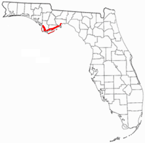
Wakulla County is a county located in the Big Bend region in the northern portion of the U.S. state of Florida. As of the 2020 census, the population was 33,764. Its county seat is Crawfordville.

<span class="mw-page-title-main">St. Marks, Florida</span> City in Florida, United States

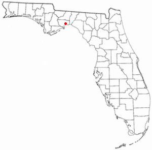
St. Marks is a city in Wakulla County, Florida, United States. It is part of the Tallahassee metropolitan area. The population was 293 at the 2010 census. As of 2018, the population estimated by the U.S. Census Bureau is 319.

<span class="mw-page-title-main">Arkansas Post</span> Historic site and museum in Arkansas County, Arkansas

The Arkansas Post, formally the Arkansas Post National Memorial, was the first European settlement in the Mississippi Alluvial Plain and present-day U.S. state of Arkansas. In 1686, Henri de Tonti established it on behalf of Louis XIV of France for the purpose of trading with the Quapaw Nation. The French, Spanish, and Americans, who acquired the territory in 1803 with the Louisiana Purchase, considered the site of strategic value. It was the capital of Arkansas from 1819 until 1821 when the territorial government relocated to Little Rock.

<span class="mw-page-title-main">Castillo de San Marcos</span> United States historic place

The Castillo de San Marcos is the oldest masonry fort in the continental United States; it is located on the western shore of Matanzas Bay in the city of St. Augustine, Florida.

<span class="mw-page-title-main">Nature Coast</span> Region in Florida

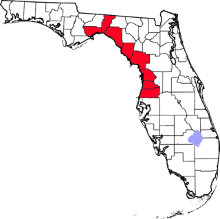
The Nature Coast is an informal, unofficial region of the U.S. state of Florida. The broadest definition of the Nature Coast includes the eight counties that abut the Gulf of Mexico along the Big Bend Coast defined by geologists: from west to east, Wakulla, Jefferson, Taylor, Dixie, Levy, Citrus, Hernando, and Pasco counties.

San Marcos is the Spanish name of Saint Mark. It may also refer to:

<span class="mw-page-title-main">William Augustus Bowles</span> American soldier and adventurer (c. 1763-1805)

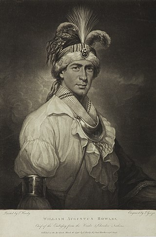
William Augustus Bowles (1763–1805), also known as Estajoca, was a Maryland soldier and adventurer. Seeing action as a Loyalist during the Revolutionary War, Bowles later formed an alliance with the Muscogee people and attempted to establish an independent indigenous American state with British support.

<span class="mw-page-title-main">Tallahassee-St. Marks Historic Railroad State Trail</span> State park in Florida, United States

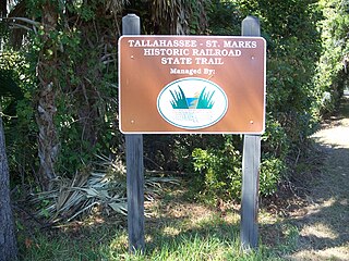
Tallahassee-St. Marks Historic Railroad State Trail is a rail trail and Florida State Park located on 16 miles (26 km) of the historic railbed of the Tallahassee Railroad, which ran between Tallahassee and St. Marks, Florida. The trail ends near the confluence of the St. Marks and Wakulla Rivers. The portion of the trail south of US 98 is designated as a portion of the Florida National Scenic Trail. A paved extension of the trail extends north for approximately 4 miles (6.4 km) into the City of Tallahassee.

<span class="mw-page-title-main">Fort Ward (Florida)</span>

Fort Ward was a Confederate States of America fort located in Wakulla County, Florida, at the confluence of the Wakulla River and St. Marks River and named after Colonel George T. Ward, owner of Southwood Plantation, Waverly Plantation, and Clifford Place Plantation south of Tallahassee. During the American Civil War, Confederate troops placed a battery of cannons at Fort Ward.

<span class="mw-page-title-main">St. Marks River</span> River in Florida, United States

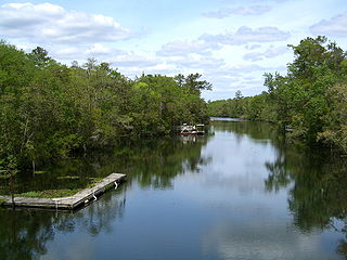
The St. Marks River is a river in the Big Bend region of Florida. It has been classified by the Florida Department of Environmental Protection as an Outstanding Florida Water, and is the easternmost river within the Northwest Florida Water Management District.

<span class="mw-page-title-main">Forgotten Coast</span> Region in Florida

The Forgotten Coast refers to a largely untouched and uninhabited area of coastline in the panhandle of the US state of Florida. The term, also a trademark, was first used in 1992, but the Forgotten Coast's exact location is not agreed upon.

<span class="mw-page-title-main">Mission San Luis de Apalache</span> United States historic place

Mission San Luis de Apalachee was a Spanish Franciscan mission built in 1656 in the Florida Panhandle, two miles west of the present-day Florida Capitol Building in Tallahassee, Florida. It was located in the descendent settlement of Anhaica capital of Apalachee Province. The mission was part of Spain's effort to colonize the Florida Peninsula and to convert the Timucuan and Apalachee Indians to Christianity. The mission lasted until 1704 when it was evacuated and destroyed to prevent its use by an approaching militia of Creek Indians and South Carolinians.

<span class="mw-page-title-main">Big Bend (Florida)</span> Region of the state Florida, United States

The Big Bend of Florida, United States, is an informally-named geographic region of North Florida where the Florida Panhandle transitions to the Florida Peninsula south and east of Tallahassee. The region is known for its vast woodlands and marshlands and its low population density relative to much of the state. The area is home to the largest single spring in the United States, the Alapaha Rise, and the longest surveyed underwater cave in the United States, the 32-mile (51 km) Wakulla-Leon Sinks cave system.

<span class="mw-page-title-main">Pike's Stockade</span> United States historic place

Pike's Stockade is a historic exploration campsite located near Sanford, Colorado. Set on the north bank of the Conejos River, it is where explorer Zebulon Pike raised the American flag on Spanish soil in 1807. The site, now managed by Historic Colorado, includes a reconstruction of a wooden stockade, built according to Pike's detailed description of the original. The site was declared a National Historic Landmark in 1961.

Pablo de Hita y Salazar was a Spanish military officer who served as governor of Spanish Florida from 1675 to 1680. The territory at the time stretched from current-day Florida west to Texas and north to South Carolina. He was best known for his work devoted to construction of the Castillo de San Marcos in St. Augustine, the capital of La Florida.

<span class="mw-page-title-main">St. Francis Barracks</span>

St. Francis Barracks is a historic structure constructed of coquina stone located on Marine Street in St. Augustine, Florida, named in honor of St. Francis of Assisi. The barracks were constructed between 1724 and 1755 by friars of the Order of St. Francis, to replace a series of wooden buildings which had been destroyed by the ravages of the tropical climate in La Florida and by fire, both accidental fires and occasional intentional ones, such as when the city was razed by the English in 1702.

Lucas Fernando Palacios y Valenzuela was a military official who served as governor of Spanish Florida from 21 April 1758 to 6 December 1761.

Manuel de Cendoya was a Spanish soldier who served as governor of Spanish Florida from mid-1671 to mid-1673. His administration is remembered primarily for initiating construction of the Castillo de San Marcos, a masonry fortress whose building had first been ordered by Cendoya's predecessor, Governor Francisco de la Guerra y de la Vega, after the destructive raid of the English privateer Robert Searle in 1668. Work proceeded in 1671, although the first stone was not laid until 1672.

References

  1. 1 2 3 4 "Fort San Marcos De Apalache". National Historic Landmark summary listing. National Park Service. Archived from the original on 2009-01-20. Retrieved 2008-06-21.
  2. 1 2 "National Register Information System". National Register of Historic Places . National Park Service. July 9, 2010.
  3. Blanche Higgins Schroer. "Fort San Marcos de Apalache". National Register of Historic Places Inventory–Nomination. National Park Service.
  4. Public Law 87-789
  5. 1 2 3 4 5 "San Marcos de Apalache Historic State Park - St. Marks, Florida". Explore Southern History. Retrieved June 17, 2012.
  6. Annual report of the Supervising Surgeon-General of the Marine Hospital Service of the United States. U.S. Government Printing Office. 1872. pp. 7–21.

Commons-logo.svg Media related to San Marcos de Apalache Historic State Park at Wikimedia Commons

Coordinates: 30°09′18″N84°12′40″W / 30.155°N 84.211°W / 30.155; -84.211