This list includes properties and districts listed on the California Historical Landmark listing in Ventura County, California. Click the "Map of all coordinates" link to the right to view a Google map of all properties and districts with latitude and longitude coordinates in the table below.
| Image | [1] | Landmark name | Location | City or town | Summary |
|---|---|---|---|---|---|
 | 939 | Grandma Prisbrey's Bottle Village | 4595 Cochran St. 34°16′44″N118°42′14″W / 34.278889°N 118.703889°W | Simi Valley | |
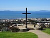 | 113 | Hill of the Cross | Grant Park 34°17′05″N119°17′46″W / 34.284821°N 119.296039°W | Ventura | |
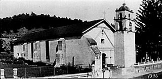
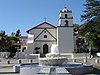 | 310 | Mission San Buenaventura | 211 E. Main St. 34°16′52″N119°17′52″W / 34.281116°N 119.297786°W | Ventura | Also on the NRHP list as NPS-75000496 |
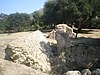
 | 114 | Old Mission Reservoir | Eastwood Park 34°16′54″N119°17′59″W / 34.281532°N 119.299613°W | Ventura | Also on the NRHP list as NPS-75000496 |
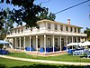
 | 115 | Olivas Adobe | 4200 Olivas Park 34°14′40″N119°14′28″W / 34.244444°N 119.241111°W | Ventura | Also on the NRHP list as NPS-79000570 |
 | 727 | Portolà Expedition | Santa Paula Boys Club Rec Center 34°21′21″N119°03′03″W / 34.35585°N 119.050867°W | Santa Paula | On August 11, 1769, the Portolá Expedition arrived at the junction of the Arroyo Mupu and Santa Paula Creek, at a place they named the Holy Martyrs Ipolito and Cassiano. The priests of the Mission San Buenaventura here established the Asistencia Santa Paula, where they held services for the Mupu Indians. |
 | 553 | Rancho Camulos | 5164 East Telegraph Rd. 34°24′20″N118°45′24″W / 34.40565°N 118.756667°W | Piru | Also on the NRHP list as NPS-96001137 |
 | 979 | Rancho Simi | 137 Strathearn Place 34°16′28″N118°48′04″W / 34.274476°N 118.801036°W | Simi Valley | |
 | 114-1 | San Buenaventura Mission Aqueduct | 234 Cañada Larga Rd. 34°20′32″N119°17′27″W / 34.342091°N 119.290809°W | Ventura | Also on the NRHP list as NPS-75000497 |
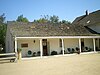
 | 659 | Stagecoach Inn | 51 Ventu Park Rd. 34°10′41″N118°54′41″W / 34.178056°N 118.911389°W | Newbury Park | Also on the NRHP list as NPS-75000495 |
 | 756 | Sycamore Tree | State Hwy 126 at Hall Rd. 34°22′44″N118°59′23″W / 34.378933°N 118.98985°W | Santa Paula | Between Santa Paula and Fillmore |
 | 996 | Union Oil Company Building | 1003 E. Main St. 34°21′15″N119°03′32″W / 34.354167°N 119.058889°W | Santa Paula | Also on the NRHP list as NPS-86002619 |
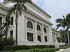 | 847 | Ventura County Courthouse | 501 Poli St. 34°16′57″N119°17′32″W / 34.2825°N 119.292222°W | Ventura | Also on the NRHP list as NPS-71000211 |
| | 624 | Warring Park | 700 block of Orchard St. 34°25′01″N118°47′29″W / 34.417083°N 118.791383°W | Piru | Portolá found Piru Indians tribe at site |