Cathedral, Colorado

Last updated

Cathedral, Colorado
Hinsdale County Colorado Incorporated and Unincorporated areas Cathedral Highlighted 0812450.svg
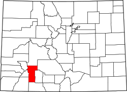
Location of the Cathedral CDP in Hinsdale County, Colorado.
Usa edcp location map.svg
Red pog.svg
Cathedral
Location of the Cathedral CDP in the United States.
Coordinates: 38°05′01″N107°01′50″W / 38.0836289°N 107.0306813°W / 38.0836289; -107.0306813 (Cathedral CDP, Colorado) [1]
Country Flag of the United States.svg  United States
State Flag of Colorado.svg  Colorado
County Hinsdale County
Government
[2]
  Type unincorporated community
Area
[1]
  Total21.279 sq mi (55.113 km2)
  Land21.279 sq mi (55.113 km2)
  Water0.000 sq mi (0.000 km2)
Elevation
[2]
9,249 ft (2,819 m)
Population
 (2020) [3]
  Total15
  Density0.70/sq mi (0.27/km2)
Time zone UTC-7 (MST)
  Summer (DST) UTC-6 (MDT)
ZIP Code [4]
Powderhorn 81243
Area code 970
GNIS feature [2] Cathedral CDP

Cathedral is a census-designated place (CDP) located in and governed by Hinsdale County, Colorado, United States. The population of the Cathedral CDP was 15 at the United States Census 2020. [3] The Powderhorn post office (Zip Code 81243) serves the area. [4]

Contents

Geography

Cathedral is located in the northeast corner of Hinsdale County on the east side of Cebolla Creek, a north-flowing tributary of the Gunnison River. The community is at the junction of County Roads 50 and 45. County Road 50 leads southwest (upstream) 15 miles (24 km) to Colorado State Highway 149 at Slumgullion Pass, from which point Lake City, the Hinsdale County seat, is 9 miles (14 km) to the northwest. County Road 50 also leads north (downstream) from Cathedral into Gunnison and eventually via County Road 27 16 miles (26 km) to Highway 149 at Powderhorn.

The Cathedral CDP has an area of 13,619 acres (55.113 km2), all land. [1]

Demographics

Cathedral CDP, Colorado
YearPop.±%
2010 14    
2020 15+7.1%
Source: United States Census Bureau

The United States Census Bureau initially defined the Cathedral CDP for the United States Census 2010.

See also

Related Research Articles

<span class="mw-page-title-main">Hinsdale County, Colorado</span> County in Colorado, United States

Hinsdale County is a county located in the U.S. state of Colorado. As of the 2020 census, the population was 788, making it the second-least populous county in Colorado. With a population density of only 0.71 inhabitants per square mile (0.27/km2), it is also the least-densely populated county in Colorado. The county seat and only incorporated municipality in the county is Lake City. The county is named for George A. Hinsdale, a prominent pioneer and former Lieut. Governor of Colorado Territory.

<span class="mw-page-title-main">Kittredge, Colorado</span> Census Designated Place in Colorado, United States

Kittredge is an unincorporated town, a post office, and a census-designated place (CDP) located in and governed by Jefferson County, Colorado, United States. The CDP is a part of the Denver–Aurora–Lakewood, CO Metropolitan Statistical Area. The Kittredge post office has the ZIP code 80457. At the United States Census 2020, the population of the Kittredge CDP was 1,308.

<span class="mw-page-title-main">Leadville North, Colorado</span> Census-designated place in Lake County, Colorado, United States

Leadville North is a census-designated place (CDP) in and governed by Lake County, Colorado, United States. The population of the Leadville North CDP was 1,892 at the United States Census 2020. The Leadville post office serves the area.

<span class="mw-page-title-main">Atwood, Colorado</span> Census Designated Place in Colorado, United States

Atwood is an unincorporated town, a post office, and a census-designated place (CDP) located in and governed by Logan County, Colorado, United States. The CDP is a part of the Sterling, CO Micropolitan Statistical Area. The Atwood post office has the ZIP Code 80722. At the United States Census 2020, the population of the Atwood CDP was 138.

<span class="mw-page-title-main">Clifton, Colorado</span> Census-designated place in Mesa County, Colorado, United States

Clifton is a census-designated place (CDP) and post office in and governed by Mesa County, Colorado, United States. It is part of the Grand Junction, CO Metropolitan Statistical Area. The Clifton post office has the ZIP Code 81520. As of the 2020 census, the population of the Clifton CDP was 20,413.

<span class="mw-page-title-main">Orchard Mesa, Colorado</span> Census-designated places in Mesa County, United States

Orchard Mesa is a census-designated place (CDP) in and governed by Mesa County, Colorado, United States. It is part of the Grand Junction, CO Metropolitan Statistical Area. The population of the Orchard Mesa CDP was 6,688 at the 2020 census. The Grand Junction post office serves the area.

<span class="mw-page-title-main">Twin Lakes, Lake County, Colorado</span> Census-designated place in Lake County, Colorado, United States

Twin Lakes is a pair of glacier-carved alpine lakes about 15 miles (24 km) south of historic Leadville, Colorado. They are downstream along the Arkansas River, whose headwaters are by Leadville. The lakes, however, are on a tributary, Lake Creek, which joins the Arkansas just below the lakes. After dredging, the lakes now have a surface area of 2,700 acres (11 km2), and they serve as a reservoir to store water for use in the Front Range. Both east and west lakes are recreation areas for boating and fishing.

<span class="mw-page-title-main">Capulin, Colorado</span> Census Designated Place in Colorado, United States

Capulin is an unincorporated town, a post office, and a census-designated place (CDP) located in and governed by Conejos County, Colorado, United States. The Capulin post office has the ZIP Code 81124. At the United States Census 2020, the population of the Capulin CDP was 134.

<span class="mw-page-title-main">Coaldale, Colorado</span> Census-designated place in Fremont County, Colorado, United States

Coaldale is a census-designated place (CDP) and post office located in and governed by Fremont County, Colorado, United States. The CDP is a part of the Cañon City, CO Micropolitan Statistical Area. The Coaldale post office has the ZIP Code 81222. At the United States Census 2020, the population of the Coaldale CDP was 343.

<span class="mw-page-title-main">Idledale, Colorado</span> Census Designated Place in Colorado, United States

Idledale is an unincorporated town, a post office, and a census-designated place (CDP) located in and governed by Jefferson County, Colorado, United States. The CDP is a part of the Denver–Aurora–Lakewood, CO Metropolitan Statistical Area. The Idledale post office has the ZIP code 80453. At the United States Census 2020, the population of the Idledale CDP was 244.

<span class="mw-page-title-main">Lewis, Colorado</span> Census-designated place in Colorado, United States

Lewis is an unincorporated town, a post office, and a census-designated place (CDP) located in and governed by Montezuma County, Colorado, United States. The Lewis post office has the ZIP Code 81327. At the 2020 census, the population of the Lewis CDP was 257, down from 302 in 2010.

<span class="mw-page-title-main">Maybell, Colorado</span> Census-designated place in Moffat County, Colorado, United States

Maybell is an unincorporated community and census-designated place (CDP) in and governed by Moffat County, Colorado, United States. The CDP is a part of the Craig, CO Micropolitan Statistical Area.

<span class="mw-page-title-main">Orchard, Colorado</span> Unincorporated community in Colorado, United States

Orchard is an unincorporated town, a post office, and a census-designated place (CDP) located in and governed by Morgan County, Colorado, United States. The CDP is a part of the Fort Morgan, CO Micropolitan Statistical Area. The Orchard post office has the ZIP Code 80649. As of the 2020 census, the population of the Orchard CDP was 76.

<span class="mw-page-title-main">Wolcott, Colorado</span> Census Designated Place in Colorado, United States

Wolcott is an unincorporated town, a post office, and a census-designated place (CDP) located in and governed by Eagle County, Colorado, United States. The CDP is a part of the Edwards, CO Micropolitan Statistical Area. The Wolcott post office has the ZIP Code 81655. At the United States Census 2020, the population of the Wolcott CDP was 20.

<span class="mw-page-title-main">Altona, Colorado</span> Census Designated Place in Colorado, United States

Altona is an unincorporated community and a census-designated place (CDP) located in and governed by Boulder County, Colorado, United States. The CDP is a part of the Boulder, CO Metropolitan Statistical Area. The population of the Altona CDP was 512 at the United States Census 2020. The Boulder post office serves the area.

<span class="mw-page-title-main">Glendale, Boulder County, Colorado</span> Census Designated Place in Colorado, United States

Glendale is an unincorporated community and a census-designated place (CDP) located in and governed by Boulder County, Colorado, United States. The CDP is a part of the Boulder, CO Metropolitan Statistical Area. The population of the Glendale CDP was 64 at the United States Census 2020. The Jamestown post office serves the area.

<span class="mw-page-title-main">Piedra, Colorado</span> Census Designated Place in Colorado, United States

Piedra is an unincorporated community and a census-designated place (CDP) located in and governed by Hinsdale County, Colorado, United States. The population of the Piedra CDP was 31 at the United States Census 2020. The Pagosa Springs post office serves the area.

<span class="mw-page-title-main">Catherine, Colorado</span> Census-designated place in Garfield County, Colorado, United States

Catherine is a census-designated place (CDP) in and governed by Garfield County, Colorado, United States. The CDP is a part of the Glenwood Springs, CO Micropolitan Statistical Area. The population of the Catherine CDP was 235 at the United States Census 2020. The Glenwood Springs post office serves the area.

<span class="mw-page-title-main">Cattle Creek, Colorado</span> Census-designated place in Garfield County, Colorado, United States

Cattle Creek is a census-designated place (CDP) in and governed by Garfield County, Colorado, United States. The CDP is a part of the Glenwood Springs, CO Micropolitan Statistical Area. The population of the Cattle Creek CDP was 662 at the United States Census 2020. The Glenwood Springs post office serves the area.

<span class="mw-page-title-main">Mulford, Colorado</span> Census-designated place in Garfield County, Colorado, United States

Mulford is a Census-designated place (CDP) in and governed by Garfield County, Colorado, United States. The CDP is a part of the Glenwood Springs, CO Micropolitan Statistical Area. The population of the Mulford CDP was 259 at the United States Census 2020. The Carbondale post office serves the area.

References

  1. 1 2 3 "State of Colorado Census Designated Places - BAS20 - Data as of January 1, 2020". United States Census Bureau . Retrieved December 22, 2020.
  2. 1 2 3 "U.S. Board on Geographic Names: Domestic Names". United States Geological Survey . Retrieved December 22, 2020.
  3. 1 2 United States Census Bureau. "Cathedral CDP, Colorado" . Retrieved April 5, 2023.
  4. 1 2 "Zip Code 81243 Map and Profile". zipdatamaps.com. 2020. Retrieved December 22, 2020.