
The Wingecarribee River, a perennial river that is part of the Hawkesbury–Nepean catchment, is located in the Southern Highlands region of New South Wales, Australia.

The Hawkesbury River, or Hawkesbury-Nepean River, is a river located northwest of Sydney, New South Wales, Australia. The Hawkesbury River and its associated main tributary, the Nepean River, almost encircle the metropolitan region of Sydney. Between Wisemans Ferry and the Pacific Ocean marks the boundary of Greater Metropolitan Sydney in the south and the Central Coast region to the north.
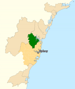
The Division of Berowra is an Australian electoral division in the state of New South Wales. The Division covers the northern parts of the Greater Sydney area with the local government areas of the Hornsby Shire and the Hills Shire.

The City of Hawkesbury is a local government area of New South Wales, Australia, the City of Hawkesbury is located on the North and North Western edge of the Greater Sydney area and is adjacent to the Sydney metropolitan area, about 50 kilometres (31 mi) north-west of the Sydney central business district. Hawkesbury City is named after the Hawkesbury River.

Sackville North is a suburb of Sydney, in the state of New South Wales, Australia 80 kilometres north-west of the Sydney central business district in the local government area of The Hills Shire.

Wisemans Ferry is a cable ferry across the Hawkesbury River in New South Wales, Australia. The ferry operates from the eponymous community of Wisemans Ferry on the south bank, to a point on the north bank downstream of the Hawkesbury River's confluence with the Macdonald River, connecting with the old Great North Road. The crossing has remained in use on its current site since 1829, making it the oldest ferry crossing still in operation in New South Wales, and possibly in Australia.

Hawkesbury is an electoral district of the Legislative Assembly in the Australian state of New South Wales. It is represented by Robyn Preston of the Liberal Party.
Glenworth Valley is a suburb of the Central Coast Council local government area in the Central Coast region of New South Wales, Australia. About 73 km (45 mi) north of Sydney and 20 km (12 mi) west of Gosford, at the 2016 census it had a population of 10 people. Popran Creek runs through the entire valley and rises in the locality of Central Mangrove and then flows for approximately 24 km (15 mi) in a mostly southern direction until it reaches Mangrove Creek.
Cumberland was an electoral district of the Legislative Assembly in the Australian state of New South Wales in outer western Sydney named after Cumberland County. It was created as a three-member electorate with the introduction of proportional representation in 1920, replacing Camden and Hawkesbury. It was abolished in 1927 and replaced by Hawkesbury, Nepean, and parts of Bankstown, Lakemba and Hornsby.

Sackville (Doorumbolooa) is a suburb of Sydney, in the state of New South Wales, Australia. It is located in the City of Hawkesbury and at the 2016 census had a population of 298, thirteen of whom identified as Aboriginal and Torres Strait Islander.

The Sackville Ferry is a cable ferry across the Hawkesbury River in New South Wales, Australia. The vehicular ferry connects the communities of Sackville, on the north/west bank of the river, and Sackville North, on the south/east bank. Because of the tortuous course of the river, the ferry actually runs north-west from Sackville to Sackville North.
The Mulwaree River, a perennial river that is part of the Hawkesbury-Nepean catchment, is located in the Southern Tablelands region of New South Wales, Australia.

The Nattai River, a perennial river that is part of the Hawkesbury-Nepean catchment, is located in the Southern Highlands region of New South Wales, Australia.

The Narara was a wooden carvel screw steamer built in 1900 at Jervis Bay, that was wrecked when it sprang a leak while carrying general cargo between Sydney and the Hawkesbury River and was lost at 2 ml SE off Little Reef Newport near, Barranjoey, New South Wales on 29 May 1909. The vessel commenced her runs from Sydney Harbour to the Hawkesbury River in January 1900 and continued on this run till the time of her final 1909 sinking. During 1903 the vessel was burned to the water line and sank at its mooring only to be refloated and rebuilt and started back on the same run.
The Little River, a perennial river that is part of the Hawkesbury-Nepean catchment, is located in the Southern Highlands region of New South Wales, Australia.
The Little River, a watercourse that is part of the Hawkesbury-Nepean catchment, is located in the Southern Highlands region of New South Wales, Australia.
Blaxland Creek, a watercourse that is part of the Hawkesbury–Nepean catchment, is located in Greater Western Sydney, Australia.

Australiana Pioneer Village is a heritage-listed open-air museum at Rose Street, Wilberforce, City of Hawkesbury, New South Wales, Australia. It was built from 1969 to 1970. The property is owned by Hawkesbury City Council. It was added to the New South Wales State Heritage Register on 20 February 2004.
Colo Shire was a local government area in the Sydney Basin region of New South Wales, Australia.
