
The Municipality of Strathfield is a local government area in the Inner West of Sydney, in the state of New South Wales, Australia.

Bingara is a small town on the Gwydir River in Murchison County in the New England region of New South Wales, Australia. Bingara is currently the administrative centre for the Gwydir Shire that was created in 2003. The Gwydir River being a main highlight of the town is a main catchment of the Murray-Darling System.
Tea Gardens is a locality in the Mid-Coast Council local government area, in Mid North Coast region of New South Wales, Australia.

Westmead is a suburb in Sydney, in the state of New South Wales, Australia. Westmead is located 26 kilometres west of the Sydney central business district in the local government area of Cumberland Council and is part of the Greater Western Sydney region.

City of Cessnock is a local government area in the Hunter region of New South Wales, Australia. The area under administration is located to the west of Newcastle. The largest population centre and council seat is the city of Cessnock.

The City of Hawkesbury is a local government area of New South Wales, Australia, located on the northern and north-western fringe of the Greater Sydney area, about 50 kilometres (31 mi) north-west of the Sydney central business district. Hawkesbury City is named after the Hawkesbury River.
Glenwood is a suburb of Sydney, in the state of New South Wales, Australia. Glenwood is located 33 kilometres north-west of the Sydney central business district in the local government area of the City of Blacktown and part of the Greater Western Sydney region.

Northwood is a suburb on the Lower North Shore of Sydney, in the state of New South Wales, Australia, eight kilometres north-west of the Sydney central business district, in the local government area of the Municipality of Lane Cove. Northwood is on the northern side of the Lane Cove River between Woodford Bay and Gore Creek.
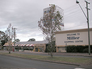
Miller is a suburb of Sydney in the state of New South Wales, Australia 38 kilometres south-west of the Sydney central business district, in the local government area of the City of Liverpool. Neighbouring suburbs include Hoxton Park, Hinchinbrook, Cartwright, Prestons, Sadleir and Busby.

Denistone West is a suburb in Northern Sydney, in the state of New South Wales, Australia. Denistone West is located 16 kilometres north-west of the Sydney central business district in the local government area of the City of Ryde. Denistone and Denistone East are separate suburbs; Denistone West was gazetted as a suburb in its own right on 5 February 1999.

Lane Cove North is a suburb on the Lower North Shore of Sydney, in the state of New South Wales, Australia. Lane Cove North is located 11 kilometres north-west of the Sydney central business district, in the local government areas of the Municipality of Lane Cove and the City of Willoughby. Lane Cove and Lane Cove West are separate suburbs.
Speers Point is a suburb of Greater Newcastle, and the location of the council seat of the City of Lake Macquarie local government area in New South Wales, Australia. It is 17 kilometres (10.6 mi) west-southwest of the city of Newcastle on the northern shore of Lake Macquarie, in Cockle and Warners Bays, between the suburbs of Cardiff and Warners Bay.

Kyogle Council is a local government area in the Northern Rivers region of New South Wales, Australia.

Ballina Shire is a local government area in the Northern Rivers region of New South Wales, Australia. The Shire was formed on 1 January 1977 by the amalgamation of the Municipality of Ballina and Tintenbar Shire. The Shire is located adjacent to the Tasman Sea and the Pacific Highway. The council seat is located in the town of Ballina. The population of the Ballina Shire area was 46,850 in 2022.

Bellingen Shire is a local government area in the Mid North Coast region of New South Wales, Australia. The shire is located adjacent to the Pacific Highway, Waterfall Way and the North Coast railway line.

Abernethy is a small town in the City of Cessnock, in the Hunter Region in the state of New South Wales, Australia. Abernethy is located 8 kilometres south-east of the town of Cessnock, NSW and is adjacent to Werakata National Park and the Aberdare State Forest. The town was founded near a coal mine and some of the historic buildings remain. In 2016 348 lived there with the median age being 32 and 74.8% being born in Australia.

Huntleys Cove is a suburb on the Lower North Shore of Sydney, in the state of New South Wales, Australia. Huntleys Cove is located 9 kilometres north-west of the Sydney central business district, in the local government area of the Municipality of Hunter's Hill. Huntleys Cove sits on the peninsula between Tarban Creek and the Parramatta River.
Osterley is a small rural suburb of the Port Stephens local government area in the Hunter Region of New South Wales, Australia. Most of the small population lives in the elevated part of the suburb along Hinton Road, east of Barties Creek which is a tributary of the Hunter River. The area to the west of Barties creek is low-lying and subject to periodic flooding. .In 2016 117 people live there with a median age of 46.

Currumbin Waters is a suburb in the City of Gold Coast, Queensland, Australia. It borders New South Wales. In the 2021 census, Currumbin Waters had a population of 9,797 people.
Biddaddaba is a rural locality in the Scenic Rim Region, Queensland, Australia. In the 2021 census, Biddaddaba had a population of 171 people.
