
Hexham is a suburb of the city of Newcastle, about 15 km (9 mi) inland from the Newcastle CBD in New South Wales, Australia on the bank of the Hunter River.

The Sutherland Shire is a local government area in the southern region of Sydney, in the state of New South Wales, Australia. The Sutherland Shire comprises an area of 370 square kilometres (140 sq mi) and as at the 2016 census had an estimated population of 218,464. Sutherland Shire is colloquially known as "The Shire" and has featured in several reality television series.

Chippendale is a small inner-city suburb of Sydney, New South Wales, Australia on the southern edge of the Sydney central business district, in the local government area of the City of Sydney. Chippendale is located between Broadway to the north and Cleveland Street to the south, Sydney Central railway station to the east and the University of Sydney to the west.
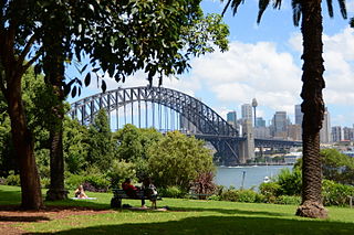
Lavender Bay is a harbourside suburb on the lower North Shore of Sydney, New South Wales, Australia. Lavender Bay is located 3 kilometres north of the Sydney central business district, in the local government area of North Sydney Council.
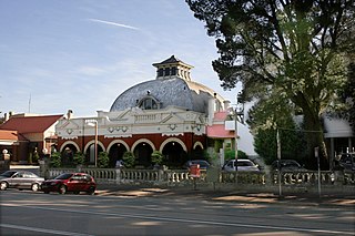
Medlow Bath is an Australian small town located near the highest point of the Blue Mountains, between Katoomba and Blackheath. Its altitude is about 1,050 metres (3,440 ft) AHD and it is about 115 kilometres (71 mi) west-north-west of the Sydney central business district and 5 kilometres (3.1 mi) north-west of Katoomba. At the 2016 census, Medlow Bath had a population of 611 people.
Yennora is a suburb of Sydney in the state of New South Wales, Australia, 29 kilometres west of the Sydney central business district. The residential part of the suburb is primarily in the local government area of the City of Fairfield, although the industrial area in west is a part of Cumberland Council. It is part of the Greater Western Sydney region.

Colebee is a suburb of Sydney, in the state of New South Wales, Australia. Colebee is located 47 kilometres west of the Sydney central business district, in the local government area of the City of Blacktown and is part of the Western Sydney region.

Dean Park is a suburb of Sydney, in the state of New South Wales, Australia. Dean Park is located 43 kilometres west of the Sydney central business district, in the local government area of the City of Blacktown and is part of the Western Sydney region.
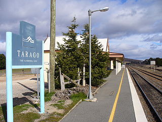
Tarago is a town in the Southern Tablelands of New South Wales, Australia in Goulburn Mulwaree Council. Part of the defined locality, which includes a large area of grazing country, is on the eastern shore of Lake George in the area of the Queanbeyan–Palerang Regional Council. The town is situated 39 kilometres south of the city of Goulburn and 69 kilometres northeast of Canberra, the capital city of Australia. It is located on the Goulburn-Braidwood road. The town is notable for recent renewable energy projects in the surrounding districts.
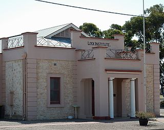
Lock is a town in the centre of Eyre Peninsula in South Australia. It is central Eyre Peninsula's main grain storage hub, as it is surrounded by a predominantly farming community, with emphasis on cereal crop production. The town has a hotel, caravan park, motel, supermarket, post office, police station, library, sporting complex, golf and bowling clubs and area school. At the 2006 census, Lock had a population of 290.

West Wallsend is a suburb and small town in the City of Lake Macquarie, Greater Newcastle in New South Wales, Australia. It is near the Sydney-Newcastle Freeway and the western suburbs of Newcastle.

Mirrool is a town in the northern part of the Riverina region of south-west New South Wales, Australia. The town is in the Bland Shire local government area and adjacent to the Newell Highway, 473 kilometres (294 mi) south west of the state capital, Sydney. At the 2011 census, Mirrool and the surrounding area had a population of 234.

Ropes Crossing is a suburb of Blacktown, Sydney in the state of New South Wales, Australia. Ropes Crossing is located 49 kilometres (30 mi) west of the Sydney central business district, in the local government area of the City of Blacktown and is part of the Greater Western Sydney region.

Noonamah is an outer rural suburban area of Darwin. it is 45 km SE of the Darwin CBD. Its Local Government Area is the Litchfield Municipality. The suburb is mostly a rural area, but has been experiencing strong growth in population and development. The Elizabeth River flows through Noonamah towards the East Arm of Darwin Harbour.

Koolanooka is a small town in the MidWest region of Western Australia. It is situated between Morawa and Perenjori just off the Mullewa-Wubin road. At the 2006 census, Koolanooka had a population of 46.

Albert is a town in the Central West region of New South Wales, Australia. The town is in the Lachlan Shire local government area, 481 kilometres (299 mi) west north west of the state capital, Sydney. At the 2016 census, Albert had a population of 81, though Albert once had a population of 900.

Pithara is a small town in the wheatbelt region of Western Australia. It is located about 240 km north of Perth, in the Shire of Dalwallinu. At the 2011 census, Pithara had a population of 257, a 25% fall from the previous 2006 census.

Coomberdale is a small town located along the Midlands Road between Moora and Watheroo in the Wheatbelt region of Western Australia. It had 64 residents in the 2016 census.
Nanson is a small town in the Mid West region of Western Australia, between the city of Geraldton and the town of Northampton. The town is situated on the banks of the Chapman River in the Chapman Valley. At the 2006 census, Nanson had a population of 386.
Gillieston Heights is a suburb of the City of Maitland local government area in the Hunter Region of New South Wales, Australia, approximately 5.1 km (3.2 mi) from the Maitland CBD. Prior to 1967, the village was named East Greta however this was changed to honour former Maitland mayor and member of the New South Wales Legislative Assembly John Gillies following a poll of residents. At the 2016 census, Gillieston Heights had a population of over 3,000.
