The City of Hawkesbury is a local government area of New South Wales, Australia, the City of Hawkesbury is located on the North and North Western edge of the Greater Sydney region and is adjacent to the Sydney metropolitan area, about 50 kilometres (31 mi) north-west of the Sydney central business district. Hawkesbury City is named after the Hawkesbury River.

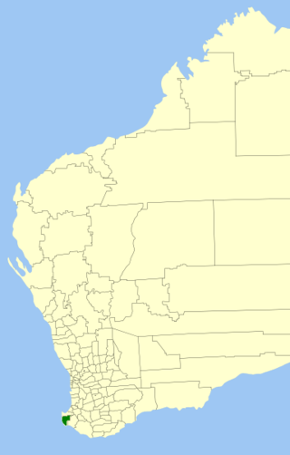
The Shire of Augusta Margaret River is a local government area in the south-west corner of the South West region of Western Australia, approximately 270 kilometres (168 mi) south of Perth. The shire covers an area of 2,243 square kilometres (866 sq mi) and had a population of over 14,000 at the 2016 Census, about half of whom live in the towns of Margaret River and Augusta.

Bigga is a village in the Southern Tablelands of New South Wales, Australia, in Upper Lachlan Shire. It is in the Parish of Bigga, County of Georgiana. The name Bigga is thought to originate as a shortened version of the Biggs Grant. Bigga is on the western side of the Abercrombie Mountains. It is 91 km northwest of Goulburn and 52 km southeast of Cowra. Nearby towns are: Abercrombie River, Binda, Greenmantle, Grabine, Reids Flat, and Tuena. Nearby places are: Blanket Flat and Crooked Corner. These places were once towns.
South Windsor is a suburb of the town of Windsor, in the state of New South Wales, Australia. It is generally bounded in the west by Rickabys Creek and in the east by South Creek, both tributaries of the Hawkesbury River. It is also home of Bede Polding College, a Catholic secondary school.
Pitt Town Bottoms is a historic town and suburb of Sydney, in the state of New South Wales, Australia. Pitt Town Bottoms is located 58 kilometres north-west of the Sydney central business district in the local government area of the City of Hawkesbury. It is bounded in the west by the Hawkesbury River.
Glenworth Valley is a suburb of the Central Coast Council local government area in the Central Coast region of New South Wales, Australia. About 73 km (45 mi) north of Sydney and 20 km (12 mi) west of Gosford, at the 2016 census it had a population of 10 people. Popran Creek runs through the entire valley and rises in the locality of Central Mangrove and then flows for approximately 24 km (15 mi) in a mostly southern direction until it reaches Mangrove Creek.
Colo is a small town located north-west of Sydney in New South Wales, Australia. It is home to the Colo River and parts of the Wollemi National Park. The main road through Colo is Putty Road. The locality of Colo is bounded in the south and the east by the Hawkesbury River.
Yellow Rock is a small village or locality in the Blue Mountains region of New South Wales, Australia. At the 2011 census, Yellow Rock had a population of 1029.

Mountain Lagoon is a small village north of Bilpin in Wollemi National Park in New South Wales, Australia in the City of Hawkesbury. The lagoon itself is an unusual feature caused by geological tilting of the plateau, located on a ridge-top above the elevation where lakes would commonly be found in this geological area. This is because of the mountain's uplift twisting the local drainage pattern. The lagoon is on private property, but can be seen from Sams Way, which encircles the lake. Part of Sams Way has been planted as an avenue of exotic trees and shrubs that have autumn and spring foliage contrasting with the native evergreen flora.
Central Macdonald is a hamlet village of Sydney, in the state of New South Wales, Australia. It is located in the City of Hawkesbury just south of St Albans. Macdonald Valley Public School is situated in the village. It was previously known as the village of Benton.
Upper Macdonald is a small village 108 km north of Sydney, in the state of New South Wales, Australia. It is located in the City of Hawkesbury on the Macdonald River north of St Albans. The village used to be known as Howick.
Higher Macdonald is a locality 116 km north of Sydney, in the state of New South Wales, Australia. It is located in the City of Hawkesbury north of Upper Macdonald.
Wheeny Creek is a locality of Sydney, in the state of New South Wales, Australia. It is located in the City of Hawkesbury north-east of Kurrajong.
Wrights Creek is a locality of Sydney, in the state of New South Wales, Australia. It is located in the City of Hawkesbury north-east of Central Macdonald.
Mogo Creek is a locality within the City of Hawkesbury, in outer metropolitan Sydney, in the state of New South Wales, Australia. It is located south-west of the town of Bucketty. Mangrove Creek Dam is within the locality, and the western half of the locality is within Yengo National Park. Mogo Creek runs adjacent to the locality.
Central Colo is a locality of Sydney, in the state of New South Wales, Australia. It is located in the City of Hawkesbury west of Colo and to the south of the Colo River near its confluence with the Hawkesbury River.
The Devils Wilderness is a suburb of Sydney, within the Hawkesbury electorate of the state of New South Wales, Australia.
Ten Mile Hollow is a locality north of Sydney, within the Hawkesbury electorate of the state of New South Wales, Australia.
Womerah is a suburb of Sydney, within the Hawkesbury electorate of the state of New South Wales, Australia.


