
Homebush is a suburb in the Inner West of Sydney in the state of New South Wales, Australia. It is located 12 kilometres west of the Sydney central business district, in the local government area of the Municipality of Strathfield.

Richmond is a historic town in north-west of Sydney, New South Wales, Australia. Richmond is in local government area of City of Hawkesbury and comes under Sydney Metropolitan area. It is located 20 metres above sea level on the alluvial Hawkesbury River flats, at the foot of the Blue Mountains. It is about 65 km by road from Sydney, 22 km from Penrith, 26 km from Blacktown, 40 km from Parramatta, 78 km from Lithgow and 5 km from Windsor. Richmond Town is now part of Sydney urban area have all amenities including Shopping Malls, Service NSW, Schools, TAFE, University, Post Office, Restaurants, Railway Station, Cafe, Hotel and Supermarkets.

Tenterfield is a regional town in New South Wales, Australia, situated at the junction of the New England and Bruxner highways, along the Northern Tablelands, within the New England region. At the 2016 census, Tenterfield had a population of 4,066. Tenterfield's proximity to many regional centres and its position on the route between Sydney and Brisbane led to its development as a centre for the promotion of the federation of Australia.

The City of Hawkesbury is a local government area of New South Wales, Australia, located on the northern and north-western fringe of the Greater Sydney area, about 50 kilometres (31 mi) north-west of the Sydney central business district. Hawkesbury City is named after the Hawkesbury River. Major towns in City of Hawkesbury are Windsor and Richmond.

Nerriga is a small village in the Southern Tablelands of New South Wales, Australia in Queanbeyan-Palerang Regional Council. It is situated at the edge of Morton National Park, on the Braidwood - Nowra road. The population of Nerriga and the surrounding localities at the 2016 census was 72.
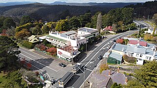
Mount Victoria is a village in the Blue Mountains of New South Wales, Australia. Mount Victoria is geographically the western most village and suburb of Greater Sydney on the great western highway in the City of Blue Mountains, located about 120 kilometres (75 mi) west-northwest by road from the Sydney central business district and at an altitude of about 1,052 metres (3,451 ft) AHD . The settlement had a population of 823 people at the 2011 Census.
North Richmond is a town and also considered as suburb of Richmond, in the state of New South Wales, Australia. North Richmond is located 67 kilometres north-west of the Sydney central business district in the local government area of the City of Hawkesbury. It is separated from Richmond to the south-east by the Hawkesbury River. North Richmond is not part of Sydney metropolitan area as its border is Hawkesbury River, however North Richmond is considered as outskirts of Sydney region. Due to Redbank, a new land estate area in North Richmond, population increased gradually from 2020.

Bells Line of Road is a 59-kilometre (37 mi) major road located in New South Wales, Australia, providing an alternative crossing of the Blue Mountains to the Great Western Highway. The eastern terminus of the road is in Richmond, 51 km northwest of Sydney, where the road continues eastward as Kurrajong Road, which intersects the A9. The western terminus of the road is in Bell, in the Blue Mountains, where the road continues as the Chifley Road.

Kurrajong is a small town in New South Wales, Australia. Kurrajong is located 75 kilometres (47 mi) north-west of Sydney, in the local government area of the City of Hawkesbury.

Berambing is a rural locality in the Blue Mountains of New South Wales, Australia. The settlement is clustered around the Bells Line of Road, between Windsor and Lithgow, 10 kilometres (6.2 mi) west of Bilpin. It is situated across both the City of Hawkesbury and City of Blue Mountains local government areas. The settlement had a population of 106 people at the 2016 census.

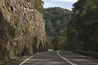
Bell is a small rural and residential village in the Blue Mountains region of New South Wales, Australia. It is the north-westernmost village in the City of Blue Mountains, located approximately 125 kilometres (78 mi) west of Sydney central business district by road or 137 kilometres (85 mi) by rail, approximately 20 kilometres (12 mi) east of Lithgow and 10 kilometres (6.2 mi) north of Mount Victoria. It is a locality on the junction of the Bells Line of Road, Chifley Road and the Darling Causeway, with an elevation of approximately 1,100 metres (3,600 ft) AHD .

Kurrajong Heights is a small town in the state of New South Wales, Australia. Kurrajong Heights is 79 kilometres (49 mi) north-west of Sydney, in the local government area of the City of Hawkesbury. It is stretched across the Bells Line of Road in the Blue Mountains, west of Kurrajong and east of Bilpin. At the 2016 census, Kurrajong Heights had a population of 1,342 people.
Kurrajong Hills is a locality in the state of New South Wales, Australia. It is 76 kilometres north-west of Sydney, in the local government area of the City of Hawkesbury. It is north of the Bells Line of Road in the Blue Mountains, west of Kurrajong and east of Bilpin.
Mount Tomah is a locality and a mountain that is located in the Blue Mountains region of the state of New South Wales, Australia. The locality is known for the Blue Mountains Botanic Garden on the Bells Line of Road.

Grose Vale is a suburb of Sydney, in the state of New South Wales, Australia. It is located in the City of Hawkesbury. It was previously known as South Kurrajong. Many historic properties are located in Grose Vale including "Lemon Forest" originally owned by the Lamrock family as well as a number of homes owned by the Dunston and Ezzy families.

Bilpin is a small town on the historic Bells Line of Road in the City of Hawkesbury local government area in the Blue Mountains, west of Sydney, New South Wales.

The Kurrajong railway line was a railway line in the distant rural western suburbs of Sydney, Australia. It was an extension of the branch off the Main Western line from Blacktown to Richmond and was operated by the New South Wales Government Railways.

Kurrajong Heights Hotel was a residential hotel on the main road from Richmond to Bell, known as Bell's Line of Road in the state of New South Wales, Australia. Kurrajong Heights is a town 79 kilometres (49 mi) north-west of Sydney, in the local government area of the City of Hawkesbury. It is stretched across the Bells Line of Road in the Blue Mountains, west of Kurrajong and east of Bilpin.
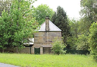
Goldfinders Inn is a heritage-listed former inn, guesthouse, general store and post office and now residence at 164 Old Bells Line of Road, Kurrajong, City of Hawkesbury, New South Wales, Australia. It was built from 1809 to 1830 by John Lamrock. It is also known as Gold Finders Rest, Kurrajong General Store and Kurrajong Post Office. It was added to the New South Wales State Heritage Register on 21 October 2016.

Australiana Pioneer Village is a heritage-listed open-air museum at Rose Street, Wilberforce, City of Hawkesbury, New South Wales, Australia. It was built from 1969 to 1970. The property is owned by Hawkesbury City Council. It was added to the New South Wales State Heritage Register on 20 February 2004.
