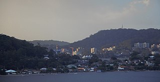
Gosford is a suburb of the Central Coast Council local government area in the heart of the Central Coast region, about 76 kilometres (47 mi) north of Sydney and about 91 kilometres (57 mi) south of Newcastle. The suburb is situated at the northern extremity of Brisbane Water, an extensive northern branch of the Hawkesbury River estuary and Broken Bay.

Richmond is a town in New South Wales, in the local government area of the City of Hawkesbury. It is located 19 metres above sea level on the alluvial Hawkesbury River flats, at the foot of the Blue Mountains on the Cumberland Plain. It is about 65 km by road from Sydney and about 78 km by road from Lithgow.

Windsor is a historic town north-west of Sydney, New South Wales, Australia. It is in the Hawkesbury local government area. The town sits on the Hawkesbury River, enveloped by farmland and Australian bush. Many of the oldest surviving European buildings in Australia are located at Windsor. It is 46 kilometres (29 mi) north-west of metropolitan Sydney, on the fringes of urban sprawl.

The City of Hawkesbury is a local government area of New South Wales, Australia, part of which is at the fringe of the Sydney metropolitan area, about 50 kilometres (31 mi) north-west of the Sydney central business district. Hawkesbury City is named after the Hawkesbury River.

Lalor Park is a suburb of Sydney, in the state of New South Wales, Australia. Lalor Park is located 35 kilometres west of the Sydney central business district in the local government area of the City of Blacktown. Lalor Park is part of the Greater Western Sydney region. Lalor Park is commonly abbreviated as 'L.P'.

Sylvania Waters is a suburb in southern Sydney located in the state of New South Wales, Australia, 21 kilometres south of the Sydney central business district in the local government area of Sutherland Shire.
North Richmond is a semi-rural suburb of Richmond, in the state of New South Wales, Australia. North Richmond is located 67 kilometres north-west of the Sydney central business district in the local government area of the City of Hawkesbury. It is separated from Richmond to the south-east by the Hawkesbury River.
Londonderry is a suburb of Greater Western Sydney, in the state of New South Wales, Australia. It is 60 kilometres north-west of the Sydney central business district, in the local government area of the City of Penrith.
Bonnyrigg Heights is a suburb of Sydney, in New South Wales, Australia. Its name originates from Bonnyrigg, Midlothian, Scotland. Bonnyrigg Heights is located on the traditional indigenous lands of the Dharug Nation.

Cattai is an historic suburb of Sydney, in the state of New South Wales, Australia. It is located 44 kilometres north-west of the Sydney central business district and 30 kilometres north-west of Parramatta. It is in the local government areas of The Hills Shire and City of Hawkesbury. Cattai's state electoral district is Hawkesbury, and its federal electoral divisions are Berowra and Macquarie.
Glossodia is a semi-rural suburb of Sydney, in the state of New South Wales, Australia. Glossodia is located 68 kilometres north-west of the Sydney central business district in the local government area of the City of Hawkesbury.
Bligh Park is a suburb of Sydney, in the state of New South Wales, Australia. Bligh Park is located 58 kilometres west of the Sydney central business district, in the local government area of the City of Hawkesbury and is part of the Greater Western Sydney region. The postcode for Bligh Park is 2756, which also covers the suburbs of Windsor, South Windsor, Windsor Downs and Ebenezer.

Sydney is Australia's most populous city, and is also the most populous city in Oceania. In the 2016 census, 5,005,400 persons declared themselves as residents of the Sydney Statistical Division–about one-fifth (19.41%) of Australia's total population. With a population density of 2037 people per square kilometre the urban core has population density five times that of the greater region.

Dangar Island is a forested island, 30.8 hectares in area, in the Hawkesbury River, just north of Sydney, New South Wales, Australia. Dangar Island is a suburb of Hornsby Shire and as at the 2016 census had a population of 303, which swells dramatically during holiday seasons. The island is serviced regularly by Brooklyn Ferry Service and departs from Brooklyn and takes about fifteen minutes. The Brooklyn ferry is itself adjacent to Hawkesbury River railway station. The ferry service is in operation 7 days a week.
Hawkesbury Heights is a small town in the state of New South Wales, Australia in the City of Blue Mountains. It is located between the townships of Yarramundi and Winmalee. To the south is Yellow Rock. The only road link to the suburb is Hawkesbury Road, which becomes Springwood Road to the east.

Kurrajong Heights is a small town in the state of New South Wales, Australia. Kurrajong Heights is 79 kilometres (49 mi) north-west of Sydney, in the local government area of the City of Hawkesbury. It is stretched across the Bells Line of Road in the Blue Mountains, west of Kurrajong and east of Bilpin. At the 2016 census, Kurrajong Heights had a population of 1,342 people.

Grose Vale is a suburb of Sydney, in the state of New South Wales, Australia. It is located in the City of Hawkesbury. It was previously known as South Kurrajong. Many historic properties are located in Grose Vale including "Lemon Forest" originally owned by the Lamrock family as well as a number of homes owned by the Dunston and Ezzy families.
East Kurrajong is a suburb located in the north-west Sydney basin, in the state of New South Wales, Australia. It is located in the City of Hawkesbury north of Glossodia and east of Kurrajong.

Bilpin is a small town on the historic Bells Line of Road in the City of Hawkesbury local government area in the Blue Mountains, west of Sydney, New South Wales.
Carnes Hill is a suburb of Sydney, in the state of New South Wales, Australia. Carnes Hill is located 38 kilometres southwest of the Sydney central business district, in the local government area of the City of Liverpool and is part of the Greater Western Sydney region.
