Richmond, New South Wales

Last updated

Richmond
Sydney,  New South Wales
Richmond Oval Sydney Australia.jpg
Richmond Oval
Australia New South Wales location map blank.svg
Red pog.svg
Richmond
Coordinates 33°36′S150°45′E / 33.600°S 150.750°E / -33.600; 150.750
Population5,418 (2021 census) [1]
Established1794
Postcode(s) 2753
Elevation20 m (66 ft)
Location
LGA(s) City of Hawkesbury
State electorate(s) Hawkesbury
Federal division(s) Macquarie
Mean max tempMean min tempAnnual rainfall
24.0 °C
75 °F
11.0 °C
52 °F
738.5 mm
29.1 in
Localities around Richmond:
North Richmond Cornwallis and Richmond Lowlands Cornwallis and Clarendon
Agnes Banks Richmond Clarendon and Windsor
Agnes Banks Hobartville and Londonderry South Windsor


Richmond is a historic town in north-west of Sydney, New South Wales, Australia. Richmond is in local government area of City of Hawkesbury and comes under Sydney Metropolitan area. It is located 20 metres above sea level on the alluvial Hawkesbury River flats, at the foot of the Blue Mountains. It is about 65 km by road from Sydney, 22 km from Penrith, 26 km from Blacktown, 40 km from Parramatta , 78 km from Lithgow and 5 km from Windsor. Richmond Town is now part of Sydney urban area have all amenities including Shopping Malls, Service NSW, Schools, TAFE, University, Post Office, Restaurants, Railway Station, Cafe, Hotel and Supermarkets.

Contents

History

The Darug people were the Aboriginal peoples in the area in 1788.

The area was originally explored by British settlers in 1789 and the nearby eminence to the west of the Hawkesbury River was known by them as 'Richmond Hill'. The name was given by Governor Arthur Phillip, in honour of Charles Lennox, the third Duke of Richmond who was Master General of Ordnance in the Pitt administration. Richmond was the fifth oldest area to have European settlement in Australia after Sydney, Parramatta, Kingston and Windsor. The first 22 European settlers came to the area in 1794 and established town. They came to farm a total of 12 hectares (30 acres) in what is now Pitt Town Bottoms. They needed good farming land to help overcome the desperate need for food in the new colony. By 1799 this region was producing about half the grain produced in the colony.

The Battle of Richmond Hill took place in May and June 1795 between the Darug people and British Marines.

Around 1811 Macquarie officially established the five Macquarie Towns in the area: Windsor, Richmond, Castlereagh, Wilberforce and Pitt Town. One of the early settlers, James Blackman, built Bowman Cottage from brick nog, a common construction technique in the colony, using money borrowed from William Cox. The house was constructed between the years 1815 and 1818. James was unable to pay his debts and was forced to sell the property to George Bowman. The building was restored by the NSW Public Works Department and then became a Division of the Australian Foundation for the Disabled, providing employment for the disabled. [2]

During WWII the RAAF operated a top secret operations bunker from somewhere in Richmond. It was either half or completely underground. The location of this bunker is unknown but it has been reported that this bunker was identical to the Bankstown Bunker which is currently buried under a public park in Bankstown. It has also been reported that this bunker could still be intact. [3]

RAAF Base Richmond is a Royal Australian Air Force base at Richmond which was established in 1923. The air base is currently the home to the RAAF's transport squadrons. During the Vietnam War, logistic support and medical evacuations were supplied by the C-130 Hercules aircraft from RAAF Richmond.

Hawkesbury Agricultural College was the first agriculture college in NSW started in 1891 later amalgamated into Western Sydney University, Hawkesbury Campus.

Attractions and Heritage listings

Major Attractions in Richmond are Richmond Oval, Pughs Lagoon, Smith Park, Richmond School of Arts, St Andrews Church, Yarramundi Reserve, Hawkesbury Race Club, Richmond Club, Polo Club, Richmond Good Food Market on Saturday morning and Hawkesbury Valley Way Visitor Centre with view of RAAF Base Airport and Maple Trees.

Richmond has a number of heritage-listed sites, including:

Population

According to the 2021 census of Population, there were 5,418 people in Richmond. Richmond Town is considered to combination of Richmond (population 5,418) and Hobartville (population 2,712) suburb. As Richmond is an established town, people from North Richmond, Agnes Banks, Bligh Park, Londonderry, and Kurrajong also comes for shopping and day to day activities.

Education

Richmond has a range of educational facilities, from primary and high schools to Technical and Further Education (TAFE) and the Hawkesbury Campus of Western Sydney University originally Hawkesbury Agricultural College.

There are three primary schools in Richmond: Richmond Public School, Hobartville Public School and St Monica's Catholic Primary School. High Schools located in Richmond are Richmond High School and Centre of Excellence in Agriculture Education (Richmond Agriculture College-partnered with TAFE and WSU).

Geography

The expansion of the Sydney suburban area has almost reached Richmond and it is now considered to be an outer suburb of Sydney. Bells Line of Road which leads into, over and across the Blue Mountains, finishing in Lithgow, starts in Richmond. Richmond railway station is the terminus of the Richmond branch. Richmond is surrounded by the 329 km2 Richmond Woodlands Important Bird Area, identified as such by BirdLife International because of the importance of the patches of remnant eucalypt woodland it contains for endangered regent honeyeaters and swift parrots. [18] Numerous times Richmond area has been flooded as its staying near to Hawkesbury River.

Richmond is surrounded by 1327 hectares land of Western Sydney University Hawkesbury campus, 270 hectares land of RAAF Base Richmond Airport and Ricmond Lowlands near Hawkesbury River. So it is the one and only isolated town in Sydney without having high density housing and population.

Transport

Richmond is connected with Road, Rail, Water ( Hawkebury River) and Air (RAAF Base Richmond) network. Major roads are Richmond Road to Blacktown, M7 and Sydney; Hawkesbury Valley Way to Windsor, A2, M2 and Sydney; Bells Line of Road to Kurrajong, Bilpin and Lithgow; Londonderry Road to Penrith and Castlereagh Road to Blue Mountains and Penrith. Richmond Railway Station which is a Terminus serves T1 and T5 Sydney Train Networks in Richmond railway line with every half an hour service to Sydney Central or Leppington. RAAF Base Richmond is a Defence Airport whereas nearby public airports are Sydney Airport and Western Sydney Airport. Frequent bus services are to Windsor, Penrith (via Londonderry and Agnes Banks), Kurrajong, Bligh Park, Grose Vale, Berambing and night bus service to Sydney (Town Hall Park St). Hawkesbury River is the main reason settlement happen in Richmond area with boats and cruises. Still people are using river for recreational purposes.


Climate

Richmond has a humid subtropical climate (Köppen: Cfa/Cwa) with hot summers and cool winters. Due to its inland location, Richmond has hotter summer days than Sydney CBD, with temperatures sometimes reaching highs of 42 °C (108 °F). Richmond's extreme summer temperatures are also credited to föhn wind sweeping off the Central Tablelands down into the foothills of the suburb. [19] Winter nights are colder than Sydney CBD's and they can drop below 0 °C (32 °F) with significant frost. Richmond has 91.5 days of clear skies annually, in contrast to Sydney CBD's 104 days. On 14 January 1939, Richmond recorded a temperature of 47.8 °C (118.0 °F), the highest in the Sydney region. Its lowest maximum winter temperature was 7.6 °C (45.7 °F), recorded on 6 July 1957.

After Mitchell, Queensland, Richmond has the second largest overall temperature range recorded in Australia; −8.3 °C (17.1 °F) to 47.8 °C (118.0 °F), a range of 56.1 °C. [20] [21]

Richmond area is considered as a flood prone area as its staying near to Hawkesbury River and when Warragamba Dam opens water will fill around Richmond area.

Climate data for Richmond RAAF (>1928)
MonthJanFebMarAprMayJunJulAugSepOctNovDecYear
Record high °C (°F)47.8
(118.0)
43.7
(110.7)
41.9
(107.4)
38.2
(100.8)
30.0
(86.0)
26.8
(80.2)
27.6
(81.7)
32.8
(91.0)
35.9
(96.6)
40.4
(104.7)
45.3
(113.5)
43.6
(110.5)
47.8
(118.0)
Mean daily maximum °C (°F)30.3
(86.5)
29.0
(84.2)
27.0
(80.6)
23.9
(75.0)
20.3
(68.5)
17.6
(63.7)
17.2
(63.0)
18.8
(65.8)
21.5
(70.7)
24.5
(76.1)
26.8
(80.2)
28.8
(83.8)
23.8
(74.8)
Mean daily minimum °C (°F)17.6
(63.7)
17.7
(63.9)
15.6
(60.1)
11.6
(52.9)
7.6
(45.7)
5.1
(41.2)
3.6
(38.5)
4.4
(39.9)
8.0
(46.4)
11.0
(51.8)
14.2
(57.6)
16.0
(60.8)
11.0
(51.9)
Record low °C (°F)8.9
(48.0)
6.4
(43.5)
3.9
(39.0)
1.1
(34.0)
−2.4
(27.7)
−6.7
(19.9)
−8.3
(17.1)
−4.8
(23.4)
−1.2
(29.8)
1.7
(35.1)
3.6
(38.5)
5.0
(41.0)
−8.3
(17.1)
Average precipitation mm (inches)75.7
(2.98)
122.9
(4.84)
75.8
(2.98)
48.6
(1.91)
48.9
(1.93)
47.5
(1.87)
28.5
(1.12)
33.2
(1.31)
48.4
(1.91)
50.6
(1.99)
82.7
(3.26)
82.7
(3.26)
719.0
(28.31)
Average precipitation days (≥ 0.2 mm)11.311.811.39.610.29.18.16.47.38.912.110.6117.5
Average afternoon relative humidity (%)50545253545549454245454849
Source 1: [22] (averages)
Source 2: [23] (humidity and records only)

Notable Personalities

Some of the notable personalities born or lived in Richmond are:

Bibliography

See also

Related Research Articles

<span class="mw-page-title-main">The Rocks, New South Wales</span> Suburb of Sydney, New South Wales, Australia

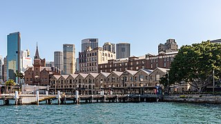
The Rocks is a suburb, tourist precinct and historic area of Sydney's city centre, in the state of New South Wales, Australia. It is located on the southern shore of Sydney Harbour, immediately north-west of the Sydney central business district.

<span class="mw-page-title-main">Windsor, New South Wales</span> Town in New South Wales, Australia

Windsor is a historic town in north-west of Sydney, New South Wales, Australia. It is the council seat of the Hawkesbury local government area. The town sits on the Hawkesbury River, enveloped by farmland and Australian bush. Many of the oldest surviving European buildings in Australia are located at Windsor. It is 56 km (35 mi) north-west of the Sydney CBD, on the fringes of urban sprawl.

<span class="mw-page-title-main">The Hills Shire</span> Local government area in New South Wales, Australia

The Hills Shire is a local government area in the Greater Sydney region of Sydney, New South Wales, Australia. The area is north-west of the Sydney central business district, and encompasses 401 square kilometres (155 sq mi) stretching from the M2 Hills Motorway in the south to Wisemans Ferry on the Hawkesbury River in the north. The Hills Shire had a population of 191,876 as of the 2021 census.

<span class="mw-page-title-main">Hornsby Shire</span> Local government area in New South Wales, Australia

Hornsby Shire is a local government area situated on the Upper North Shore as well as parts of the Hills District, of Sydney in the state of New South Wales, Australia. The shire stretches from the M2 Hills Motorway in the south to the Hawkesbury River town of Wisemans Ferry, some 53 kilometres (33 mi) to the north, making it the largest local government council in the Greater Sydney Metropolitan region by total area. As of the 2016 census the shire had an estimated population of 142,667.

<span class="mw-page-title-main">Richmond railway station, Sydney</span> Railway station in Sydney, New South Wales, Australia

Richmond railway station is the heritage-listed terminus railway station of the Richmond line, serving the Sydney suburb of Richmond, in New South Wales, Australia. It is served by Sydney Trains T1 Western and T5 Cumberland line services. It was added to the New South Wales State Heritage Register on 2 April 1999.

<span class="mw-page-title-main">City of Blue Mountains</span> Local government area in New South Wales, Australia

The City of Blue Mountains is a local government area of New South Wales, Australia, governed by the Blue Mountains City Council. The city is located in the Blue Mountains, on the Great Dividing Range at the far western fringe of the Greater Sydney area. Major settlements include, Katoomba, Lawson, Springwood and Blaxland.

<span class="mw-page-title-main">City of Campbelltown (New South Wales)</span> Local government area in New South Wales, Australia

The City of Campbelltown is a local government area in the Macarthur region of south-western Sydney, in New South Wales, Australia. The area is located about 55 kilometres (34 mi) south west of the Sydney central business district and comprises 312 square kilometres (120 sq mi).

Wilberforce is a small town in New South Wales, Australia, in the local government area of the City of Hawkesbury. It is just beyond the outer suburbs of north-west Sydney and lies on the western bank of the Hawkesbury River.

North Richmond is a town and also considered as suburb of Richmond, in the state of New South Wales, Australia. North Richmond is located 67 kilometres north-west of the Sydney central business district in the local government area of the City of Hawkesbury. It is separated from Richmond to the south-east by the Hawkesbury River. North Richmond is not part of Sydney metropolitan area as its border is Hawkesbury River, however North Richmond is considered as outskirts of Sydney region. Due to Redbank, a new land estate area in North Richmond, population increased gradually from 2020.

<span class="mw-page-title-main">Millers Point, New South Wales</span> Suburb of Sydney, New South Wales

Millers Point is an inner-city suburb of Sydney, in the state of New South Wales, Australia. It is on the north-western edge of the Sydney central business district, adjacent to The Rocks and is part of the local government area of the City of Sydney.

<span class="mw-page-title-main">Hobartville</span> Historic site in New South Wales, Australia

Hobartville is a heritage-listed farm and residence at Kurrajong Road, Richmond, City of Hawkesbury, New South Wales, Australia. It was added to the New South Wales State Heritage Register on 2 April 1999.

<span class="mw-page-title-main">Mortimer Lewis</span> English-born architect, surveyor and public servant (1796–1879)

Mortimer William Lewis was an English-born architect, surveyor and public servant who migrated to Australia and became Colonial Architect in the colony of New South Wales from 1835 to 1849. Lewis was responsible for designing and overseeing many government buildings in Sydney and rural New South Wales, many of which are heritage listed.

<span class="mw-page-title-main">Dubbo Regional Council</span> Local government area in New South Wales, Australia

The Dubbo Regional Council is a local government area located in the Central West and Orana regions of New South Wales, Australia. The council was formed on 12 May 2016 through a merger of the City of Dubbo and Wellington Council as part of a widespread council amalgamation program. It was initially named Western Plains Regional Council for almost four months, and its name was changed to Dubbo Regional Council on 7 September 2016.

<span class="mw-page-title-main">Macquarie Arms Hotel</span> Historic site in New South Wales, Australia

Macquarie Arms Hotel is a heritage-listed hotel at Thompson Square, Windsor, City of Hawkesbury, New South Wales, Australia. It is also known as the Royal Hotel. It was added to the New South Wales State Heritage Register on 2 April 1999.

<span class="mw-page-title-main">Bowman House, Richmond</span> Historic site in New South Wales, Australia

Bowman House is a heritage-listed former residence and now Hawkesbury Area Office of the National Parks and Wildlife Service at 368-370 Windsor Street, Richmond, City of Hawkesbury, New South Wales, Australia. It was built from 1817 to 1820 by James Blackman. It is also known as Bowman's Cottage. It was added to the New South Wales State Heritage Register on 2 April 1999.

<span class="mw-page-title-main">Toxana</span> Historic site in New South Wales, Australia

Toxana is a heritage-listed residence and initial premises of the Hawkesbury Agricultural College (1891-1896) at 147 Windsor Street, Richmond, City of Hawkesbury, New South Wales, Australia. It was added to the New South Wales State Heritage Register on 2 April 1999.

The North Street residences are a group of individually heritage-listed residences in North Street, Windsor, City of Hawkesbury, New South Wales, Australia. It is also known as the North Street Group. The cottages were added to the New South Wales State Heritage Register on 2 April 1999. They are often grouped with the adjacent former Court House Hotel building. The residence, along with the hotel, had previously been listed both jointly and individually on the former Register of the National Estate on 21 March 1978.

<span class="mw-page-title-main">5 Thompson Square, Windsor</span> Historic site in New South Wales, Australia

5 Thompson Square is a heritage-listed residence and now offices at 5 Thompson Square, Windsor, City of Hawkesbury, New South Wales, Australia. It was added to the New South Wales State Heritage Register on 2 April 1999.

<span class="mw-page-title-main">Allison's Pharmacy</span> Historic site in New South Wales, Australia

Allison's Pharmacy is a heritage-listed commercial building at 257-259 Windsor Street, Richmond, City of Hawkesbury, New South Wales, Australia. It was added to the New South Wales State Heritage Register on 2 April 1999.

<span class="mw-page-title-main">126 Windsor Street, Richmond</span> Historic site in New South Wales, Australia

126 Windsor Street, Richmond is a heritage-listed residence at 126 Windsor Street, Richmond, City of Hawkesbury, New South Wales, Australia. It is also known as the Home of John Town and Heritage Cottage. It was added to the New South Wales State Heritage Register on 2 April 1999.

References

  1. 1 2 Australian Bureau of Statistics (27 June 2017). "Richmond (Hawkesbury) (State Suburb)". 2016 Census QuickStats. Retrieved 8 January 2018. OOjs UI icon edit-ltr-progressive.svg
  2. Bowman Cottage Page:Retrieved 22 March 2009
  3. Treseder, Peter (January–March 1994). "Backyard adventure uncovers a wartime secret". Australian Geographic. pp. 17–18. Archived from the original on 12 October 2007.
  4. "Richmond Railway Station and yard group". New South Wales State Heritage Register . Department of Planning & Environment. H01236. Retrieved 18 May 2018. CC BY icon.svg Text is licensed by State of New South Wales (Department of Planning and Environment) under CC-BY 4.0 licence .
  5. "Seymours House". New South Wales State Heritage Register . Department of Planning & Environment. H00681. Retrieved 18 May 2018. CC BY icon.svg Text is licensed by State of New South Wales (Department of Planning and Environment) under CC-BY 4.0 licence .
  6. "Building, outbuildings, grounds, trees". New South Wales State Heritage Register . Department of Planning & Environment. H00753. Retrieved 18 May 2018. CC BY icon.svg Text is licensed by State of New South Wales (Department of Planning and Environment) under CC-BY 4.0 licence .
  7. "Richmond Park". New South Wales State Heritage Register . Department of Planning & Environment. H01808. Retrieved 18 May 2018. CC BY icon.svg Text is licensed by State of New South Wales (Department of Planning and Environment) under CC-BY 4.0 licence .
  8. "Clear Oaks Moxey's Farm House". New South Wales State Heritage Register . Department of Planning & Environment. H00058. Retrieved 18 May 2018. CC BY icon.svg Text is licensed by State of New South Wales (Department of Planning and Environment) under CC-BY 4.0 licence .
  9. "Mountain View". New South Wales State Heritage Register . Department of Planning & Environment. H00044. Retrieved 18 May 2018. CC BY icon.svg Text is licensed by State of New South Wales (Department of Planning and Environment) under CC-BY 4.0 licence .
  10. "Hobartville, including outbuildings". New South Wales State Heritage Register . Department of Planning & Environment. H00035. Retrieved 18 May 2018. CC BY icon.svg Text is licensed by State of New South Wales (Department of Planning and Environment) under CC-BY 4.0 licence .
  11. "House". New South Wales State Heritage Register . Department of Planning & Environment. H00045. Retrieved 18 May 2018. CC BY icon.svg Text is licensed by State of New South Wales (Department of Planning and Environment) under CC-BY 4.0 licence .
  12. "Toxana". New South Wales State Heritage Register . Department of Planning & Environment. H00014. Retrieved 18 May 2018. CC BY icon.svg Text is licensed by State of New South Wales (Department of Planning and Environment) under CC-BY 4.0 licence .
  13. "Building". New South Wales State Heritage Register . Department of Planning & Environment. H00610. Retrieved 18 May 2018. CC BY icon.svg Text is licensed by State of New South Wales (Department of Planning and Environment) under CC-BY 4.0 licence .
  14. "Richmond Post Office". New South Wales State Heritage Register . Department of Planning & Environment. H01410. Retrieved 18 May 2018. CC BY icon.svg Text is licensed by State of New South Wales (Department of Planning and Environment) under CC-BY 4.0 licence .
  15. "Bowman House". New South Wales State Heritage Register . Department of Planning & Environment. H00468. Retrieved 18 May 2018. CC BY icon.svg Text is licensed by State of New South Wales (Department of Planning and Environment) under CC-BY 4.0 licence .
  16. "St Peter's Anglican Church Group". New South Wales State Heritage Register . Department of Planning & Environment. H02028. Retrieved 24 October 2019. CC BY icon.svg Text is licensed by State of New South Wales (Department of Planning and Environment) under CC-BY 4.0 licence .
  17. "Administrative Block, Blacksmith Shop and Stable Square | NSW Environment, Energy and Science". environment.nsw.gov.au. Retrieved 4 March 2020.
  18. "IBA: Richmond Woodlands". Birdata. Birds Australia. Archived from the original on 6 July 2011. Retrieved 28 September 2011.
  19. Sharples, J.J., McRae, R.H.D., Weber, R.O., Mills, G.A. (2009) Foehn-like winds and fire danger anomalies in southeastern Australia. Proceedings of the 18th IMACS World Congress and MODSIM09. 13–17 July, Cairns.
  20. Climate statistics for Mitchell Post Office, Bureau of Meteorology
  21. Climatic Extremes by Geoscience Australia from the Australian Government
  22. "Climate Statistics: Richmond RAAF (1993–present)". Bureau of Meteorology . Retrieved 5 September 2014.
  23. "Climate Statistics: Richmond RAAF (1928–1994)". Bureau of Meteorology . Retrieved 5 September 2014.