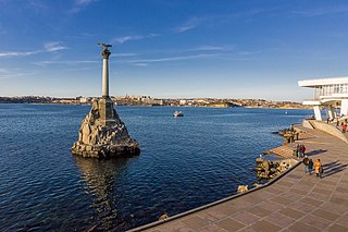
Sevastopol, sometimes written Sebastopol, is the largest city in Crimea and a major port on the Black Sea. Due to its strategic location and the navigability of the city's harbours, Sevastopol has been an important port and naval base throughout its history. Since the city's founding in 1783 it has been a major base for Russia's Black Sea Fleet, and it was previously a closed city during the Cold War. The total administrative area is 864 square kilometres (334 sq mi) and includes a significant amount of rural land. The urban population, largely concentrated around Sevastopol Bay, is 479,394, and the total population is 509,992.
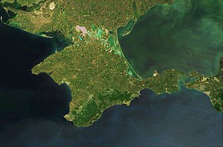
Crimea is a peninsula in Eastern Europe, on the northern coast of the Black Sea. It has a population of 2.4 million, made up mostly of ethnic Russians, with significant Ukrainian and Crimean Tatar minorities. The peninsula is almost entirely surrounded by the Black Sea and the smaller Sea of Azov. The Isthmus of Perekop connects the peninsula to Kherson Oblast in mainland Ukraine. To the east, the Crimean Bridge, constructed in 2018, spans the Strait of Kerch, linking the peninsula with Krasnodar Krai in Russia. The Arabat Spit, located to the northeast, is a narrow strip of land that separates the Sivash lagoons from the Sea of Azov. Across the Black Sea to the west lies Romania and to the south is Turkey.

The administrative divisions of Ukraine are subnational administrative divisions within the geographical area of Ukraine under the jurisdiction of the Ukrainian Constitution. Ukraine is a unitary state with four tiers of subnational government: (1) oblasts or regions (mostly), (2) raions or districts, (3) city councils and (4) rural councils.

Dzhankoi or Jankoy is a town of regional significance in the north of the Crimea. It also serves as administrative centre of Dzhankoi Raion although it is not a part of the raion (district). Population: 38,622 .

Sevastopol International Airport (Ukrainian: Міжнародний аеропорт Севастополь "Бельбек", is a military airfield in Belbek, a village near Sevastopol, Crimea.
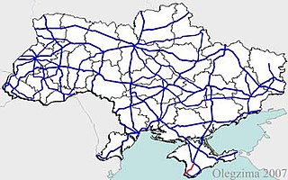
State highways in Ukraine are subdivided into three categories: international (M-network), national (H-network), and regional (P-network). The letter's indexes are in Cyrillic, standing for their respective abbreviations in Ukrainian.

Highway M20 is the second shortest Ukraine international highway (M-highway) which connects Kharkiv to the border with Russia at Hoptivka in Kharkiv Raion in Kharkiv Oblast (Kharkivshchyna) and Nehoteevka in Belgorodsky Raion in Belgorodskaya Oblast. The section from Lisne to the Russian border is part of European route E105, known as the Crimea Highway in Russia.

The Autonomous Republic of Crimea, commonly known as Crimea, is a de jure autonomous republic of Ukraine encompassing most of Crimea that was annexed by Russia in 2014. The Autonomous Republic of Crimea occupies most of the peninsula, while the City of Sevastopol occupies the rest.

In February and March 2014, Russia invaded and subsequently annexed the Crimean Peninsula from Ukraine. This event took place in the aftermath of the Revolution of Dignity and is part of the wider Russo-Ukrainian War.

The Republic of Crimea is a federal subject (republic) of Russia. Before its invasion and annexation by Russia in 2014, the territory was administered by Ukraine as the Autonomous Republic of Crimea, and most countries recognize it as such.
The Crimean problem or the Crimean question is a dispute over the status of Crimea between Ukraine and Russia. The dispute began during the dissolution of the Soviet Union, but did not escalate into a conflict until the 2014 Ukrainian revolution, when Russian special forces were deployed to occupy Crimea and took over its government buildings. The official results of a disputed referendum held during the Russian occupation indicated overwhelming support for annexation to Russia, and the Supreme Council of Crimea unilaterally declared their independence from Ukraine as a state under the name of Republic of Crimea. The republic was then annexed by Russia, whereby the former Autonomous Republic of Crimea became the "Republic of Crimea" as a Russian republic and former city with special status of Sevastopol became a Russian federal city. Ukraine and the majority of the international community continue to regard Crimea as occupied Ukrainian territory. Despite international opinion however, the currency, tax, time zone and legal system are all operational under de facto Russian control. Ukraine has attempted to resolve the matter by filing litigation in multiple international criminal, environmental, political, and other courts.
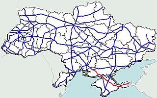
Highway M17 is a Ukrainian international highway (M-highway) connecting Kherson to the Russian border over the Kerch Strait, where it continues into Russia as the A290. The M17 is part of European route E97.
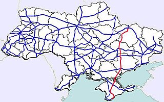
Highway M18 is a Ukrainian international highway (M-highway) connecting Kharkiv to the southern coast of Crimea in Yalta. The highway is also has an alternative route (M29) which runs parallel and designed as an expressway between Kharkiv and Novomoskovsk. The section from Novomoskovsk to Yalta is part of European route E105. The section from Kharkiv to Krasnohrad was previously P51.

The Crimea Railway is a railroad located in Crimea, providing passenger and freight services to Sevastopol and the Republic of Crimea.
H09 is a national road (H-Highway) in Lviv Oblast, Ivano-Frankivsk Oblast and Zakarpattia Oblast, Ukraine. It runs north-south and connects Mukachevo with Lviv.

H05 is a regional road (H-Highway) in Crimea, Ukraine. It runs north-south and connects Krasnoperekopsk with Simferopol. Since the 2014 annexation of Crimea by the Russian Federation, the route was given another code 35K-001.
H06 is a regional road (H-Highway) in Crimea and Sevastopol. It runs northeast-south-southwest and connects Simferopol with Sevastopol. Since the 2014 annexation of Crimea by the Russian Federation, the route was given another code 35P-001 and 67P-1.
Medvenka is an urban locality in Medvensky District of Kursk Oblast, Russia. Population: 4,398 (2010 Census); 4,595 (2002 Census); 4,446 (1989 Census).
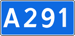
The Tavrida Highway is a Russian-constructed highway in Crimea, designated as a federal route A291 by the Russian administration. It is a four-lane motor road with a length of 250.7 km. Construction of the road began in 2017. The project's costs exceed 150 bln rubles. The construction is funded from the federal target program for the development of the Crimea and Sevastopol.
Verkhny Lyubazh is a rural locality and the administrative center of Verkhnelyubazhsky Selsoviet Rural Settlement, Fatezhsky District, Kursk Oblast, Russia. Population: 1,674 (2010 Census); 1,925 (2002 Census);

