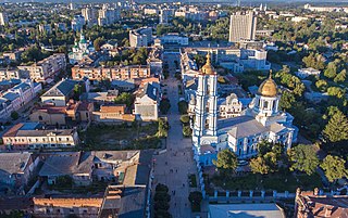
Sumy is a city of regional significance in Ukraine, and the capital of Sumy Oblast. The city is situated on the banks of the Psel River in northeastern Ukraine with a population of 256,474 according to the 2021 census, making it the 23rd-largest in the country.
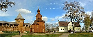
Baturyn, is a historic city in Chernihiv Oblast (province) of northern Ukraine. It is located in Nizhyn Raion (district) on the banks of the Seym River. Baturyn lost its city status in 1923 and received it back only in 2008. It hosts the administration of Baturyn urban hromada, one of the hromadas of Ukraine. Population: 2,458.

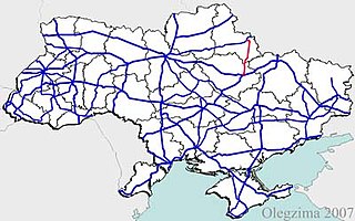
M01 is a Ukraine international highway (M-highway) that stretches from the state capital, Kyiv, to the northern border with Belarus.

Roads in Ukraine is a network of automobile roads that includes various types of roadways. The roads are usually categorized into general (public) use including streets and roads within populated areas, and other including official, private, and special use. The general use roadways are the main traveling routes and some better are part of the E-road network. High-speed highways (motorways), however, locally known as avtomahistrali or expressways are rare and only available on selected segments of major routes. Big construction projects to improve the national road infrastructure was announced in early 2010 in preparation to the Euro 2012 football competition and there was established Ministry of Infrastructure of Ukraine headed by Borys Kolesnikov. The reality turned to be more prosaic and the road infrastructure continues to be among main problems in the country.
State highways in Ukraine are subdivided into three categories: international (M-network), national (H-network), and regional (P-network). The letter's indexes are in Cyrillic, standing for their respective abbreviations in Ukrainian.

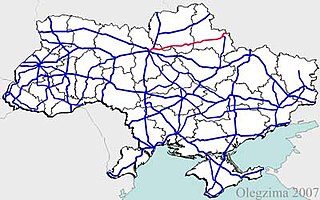
Highway M02 is a Ukraine international highway (M-highway) connecting the M01 near Kipti with Bachivsk on the border with Russia, where it continues as the M3 to Moscow. The entire route is part of European route E101 and the section from Hlukhiv to the Russian border is part of European route E391.

Highway H01 is a Ukrainian national highway (H-highway) connecting the capital of Ukraine Kyiv with the central regions. It runs through Kyiv, Kyiv Oblast, Cherkasy Oblast, and ends in Kirovohrad Oblast.

Hetman National Nature Park is a national park of Ukraine that follows floodplains and terraces of the right bank of the Vorskla River. The park is administrative in Velyka Pysarivka District, Okhtyrka District, and Trostianets District of Sumy Oblast.

National Historical and Cultural Reserve "Hetman's Capital" is a Ukrainian historical and cultural reserve of national importance.
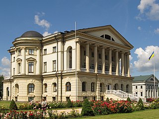
The Razumovski Palace or the Palace of Hetman of Ukraine Kyrylo Rozumovskyi is an architectural monument of national importance in the city of Baturyn in Chernihiv Oblast (province) in Ukraine. It is a museum of the National Historical and Cultural Reserve “Hetman's Capital” and the only architectural masterpiece of Charles Cameron in Ukraine.

The Baturyn Museum of Archeology is a museum of the National Historical and Cultural Reserve “Hetman's Capital” in Baturyn, Chernihiv Oblast, Ukraine.
H12 is an important Ukraine national highway (H-highway) in Sumy and Poltava Oblasts, Ukraine, running mainly north–south, and connecting Sumy with Poltava in a more or less straight line. It begins in Sumy at Bandera Street and Illinska Street, and travels straight through central Sumy. It passes through Syrovatka, Boromlya, Trostyanets, Klymentove, Okhtyrka, Khukhra, Kotelva, Velyki Budyshcha, and Dykanka, and then loops around Poltava and terminates at the intersection of Highway M03 and Polovky Street.
H07 is an important Ukraine national highway (H-highway) in Kyiv, Chernihiv, and Sumy Oblasts, Ukraine, running mainly west-east, and connecting Kyiv with Yunakivka in a more or less straight line. It begins in Brovary at Highway M01/Highway E95, and passes through Krasylivka, Hoholiv, Rusaniv, Peremoha, Nova Basan, Novyi Bykiv, Pohreby, Rudivka, Pryluky, Okhyrky, Sribne, Kharkove, Lavirkove, Romny, Korovyntsi, Nedryhailiv, Vylshana, Komyshanka, Shtepivka, Sula, Sad, Sumy, Stetskivka, Pysarivka, and Yunakivka, before ending at the Russian border. The road then continues as the R200 to Kursk.
P44 is a regional Ukraine road (P-highway) in Sumy Oblast, Ukraine, half of it running mainly north-south and the other half at an angle. It connects Hlukhiv with Sumy. It begins at Highway P61 and Bilopilskiy Shlyakh in Sumy and passes through Postolne, Synyak, Barylo, Peremoha, Bilopillya, Vorozhba, Pisky, Klepaly, Ihorivka, Chumakove, Zinove, Putivl, Bobyne, Vyazenka, Banychi, and Peremoha, and ends in Hlukhiv at the intersection of Tereschenkiv Street and Kyievo-Moskovska Street.
P45 is a regional Ukraine road (P-highway) in Sumy Oblast and Kharkiv Oblast, Ukraine, running mainly north-south and connecting Sumy with Bohodukhiv in sloped line. It begins in Sumy at Bandera Street and Illinska Street, and travels straight through central Sumy. It passes through Verkhnya Syrovatka, Stinka, Hlybne, Samotoivka, Krasnopillya, Zemlyane, Mezenivka, Slavhorod, Porozok, Pozhnya, Druzhba, Shurove, Shyrokyi Bereh, Vilne, Velyka Pysarivka, Rozsoshi, Vinnytski Ivany, Leskivka, before terminating in Bohodukhiv at Tretyakivska Street and Kharkivska Street.
P46 is a regional Ukraine road (P-highway) in Sumy Oblast and Kharkiv Oblast, Ukraine, running mainly west–east and connecting Okhtyrka with Kharkiv in a more or less straight line. It begins at Highway H12 in Okhtyrka and passes through Khodunaivka, Kupjevakha, Hubarivka, Bohodukhiv, Musiyki, Krysynska, Maksymivka, Horkoho, Vilshany, Dvorichnyi Kut, Peresichne, Solonytsivka, Podvirky, and finally arrives to the Kholodnohirsk District of Kharkiv at Zalyutynska Street and Poltavskyi Shlyakh Street.

The M5 highway, during Soviet period referred to as the M14, is the longest road in Moldova, with a length of 370 km (230 mi) running from the north to the south-east. Having national road status, it is also one of the most important routes as it provides access to the three largest cities of Moldova within its internationally recognized borders: Bălți, Chișinău and Tiraspol. It forms part of the European routes E58, E581 and E583 of the International E-road network.

H16 is a national road (H-Highway) in Cherkasy Oblast, Ukraine.