
Ivano-Frankivsk Oblast, also referred to as Ivano-Frankivshchyna, is an oblast (region) in western Ukraine. Its administrative center is the city of Ivano-Frankivsk. As is the case with most other oblasts of Ukraine this region has the same name as its administrative center – which was renamed by the Soviet Ukrainian authorities after the Ukrainian writer Ivan Franko on 9 November 1962. It has a population of 1,351,822.

The Central Stadium is a multi-purpose stadium in Cherkasy, Ukraine. It is currently used mostly for football matches, and was the home of FC Dnipro Cherkasy and now the home of FC Cherkaskyi Dnipro. The stadium holds 10,321 people.

M01 is a Ukraine international highway (M-highway) that stretches from the state capital, Kyiv, to the northern border with Belarus.

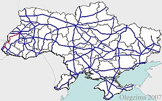
Roads in Ukraine is a network of automobile roads that includes various types of roadways. The roads are usually categorized into general (public) use including streets and roads within populated areas, and other including official, private, and special use. The general use roadways are the main traveling routes and some better are part of the E-road network. High-speed highways (motorways), however, locally known as avtomahistrali or expressways are rare and only available on selected segments of major routes. Big construction projects to improve the national road infrastructure was announced in early 2010 in preparation to the Euro 2012 football competition and there was established Ministry of Infrastructure of Ukraine headed by Borys Kolesnikov. The reality turned to be more prosaic and the road infrastructure continues to be among main problems in the country.
The following outline is provided as an overview of and topical guide to Ukraine:

The General Secretariat of Ukraine was the autonomous Ukrainian executive government of the Russian Republic from June 28, 1917 to January 22, 1918. For most of its existence it was headed by Volodymyr Vynnychenko.

Highway M08 is the shortest Ukraine international highway. It serves as a loop route bypassing the city of Uzhhorod on the northern (mountainous) side. It is part of European route E50 and European route E58.
Chystiakove, formerly Torez, is a city of regional significance in the Donetsk Oblast in Ukraine. The city is a center of the regional coal industry and much of its economy relies on mining industries, despite a recent drop in the number of employed miners. The city has a population of 53,462

Highway M19 is a Ukrainian international highway (M-highway) that completely corresponds to whole length of European route E85 that runs through Ukraine.

H20 is an important Ukraine national highway (H-highway) in the Donetsk Oblast, Donbas, Ukraine, running mainly north–south and connecting Sloviansk though Donetsk with Mariupol on the shores of Taganrog Bay in the Sea of Azov near the mouth of the Kalmius River. It passes through Kramatorsk, Druzhkivka, Oleksijevo-Druzhkivka & Osykove, Kostiantynivka, Berestok, Romanivka, Kamianka in Yasynuvats’kyi, Makiivka, Donetsk, Dolya in Volnovas'kyi, Syhnal'ne-Olenivka in Marinskyi, Berezove in Marinskyi, Novotroits'ke in Volnovas'kyi, Buhas, Volnovakha, Dmytrivka, Polkove, Pryvil'ne, Hranitne, and Kasyanivka in Telmanove Raion.

H21 is an important Ukraine national highway (H-highway) in the Donetsk Oblast and Luhansk Oblast of Donbas, Ukraine. It connects Donetsk through Luhansk with Starobilsk. The highway runs both, west–east between Donetsk and Luhansk, and south–north between Luhansk and Starobilsk. It passes either through or near Makiivka, Kolosnykove, Khartsyzk, Zuhres; Serdyte, Molodetske, and Shakhtarsk in Shakhtarsky; Torez, Snizhne, Miusynsk, Krasnyi Luch; Ivanivka and Malomykolaivka in Antratsitivsky; Myrne, Uspenka, Lutuhyne, and Heorhiivka in Lutuhynsky; Luhansk; Metalisk, Stukalova Balka, and Lyman-Tsvitni Pisky-Svitle in Slovianoserbsky; Shchastia; Mykhailivka in Troitsky; Novoaidar, Denezhnykove, and Peremorzhne-Shtormove in Novoaidarsky; Shul'hynka in Markivsky, Baidivke, and Polovynkyne in Starobilsky.

H28 is a national road (H-Highway) in Chernihiv Oblast, Ukraine. It runs north-south and connected Chernihiv with a tri-side border. Before 2017, H28 was numbered as P13.
P14 is a regional road (P-Highway) in Volyn Oblast, Ukraine. It runs north-south and connects Lutsk with the Belarus-Ukraine border.
P53 road is a regional road (P-Highway) in Zakarpattia Oblast, Ukraine. It runs north-south and connects Malyi Bereznyi with a Slovakia-Ukraine border. It is one of the shortest routes.
H13 is a national road (H-Highway) in Lviv Oblast and Zakarpattia Oblast, Ukraine. It runs north-south and connects Uzhhorod with Lviv.
P21 road is a regional road (P-Highway) in Zakarpattia Oblast and Ivano-Frankivsk, Ukraine. It runs north-south and connects cities of Dolyna and Khust.
H09 is a national road (H-Highway) in Lviv Oblast, Ivano-Frankivsk Oblast and Zakarpattia Oblast, Ukraine. It runs north-south and connects Mukachevo with Lviv.

H02 is a regional road (H-Highway) in Kyiv Oblast and Ternopil Oblast, Ukraine. It runs west-east and connects Radyvyliv with Sofiivka. The section from Kremenets to Rzhyshchiv was previously a portion of P32.

H06 is a regional road (H-Highway) in Crimea and Sevastopol. It runs northeast-south-southwest and connects Simferopol with Sevastopol. Since the 2014 annexation of Crimea by the Russian Federation, the route was given another code 35P-001 and 67P-1.
P46 is a regional Ukraine road (P-highway) in Sumy Oblast and Kharkiv Oblast, Ukraine, running mainly west–east and connecting Okhtyrka with Kharkiv in a more or less straight line. It begins at Highway H12 in Okhtyrka and passes through Khodunaivka, Kupjevakha, Hubarivka, Bohodukhiv, Musiyki, Krysynska, Maksymivka, Horkoho, Vilshany, Dvorichnyi Kut, Peresichne, Solonytsivka, Podvirky, and finally arrives to the Kholodnohirsk District of Kharkiv at Zalyutynska Street and Poltavskyi Shlyakh Street.