
Highway M05 is a state international highway in Ukraine connecting the two largest cities: Kyiv and Odessa.

P04road is a state regional road in Ukraine connecting the capital of Ukraine, Kyiv and town Zvenyhorodka in Cherkasy Oblast. It is 212.6 km (132.1 mi) long. The route starts in Kyiv, goes through Fastiv, Bila Tserkva, Tarashcha and ends in Zvenyhorodka.

M01 is a Ukraine international highway (M-highway) that stretches from the state capital, Kyiv, to the northern border with Belarus.
State highways in Ukraine are subdivided into three categories: international (M-network), national (H-network), and regional (P-network). The letter's indexes are in Cyrillic, standing for their respective abbreviations in Ukrainian.

Highway M23 is one of the shortest Ukrainian international highway (M-highway) which connects Berehove with Khust and runs in the southern portion of the region next to the Hungarian and Romanian borders. From Berehove to the little settlement of Vylok the M23 is part of European route E58 and European route E81 which drift of towards the Romanian border at the border checkpoint Okli on a regional route.
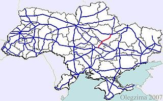
Highway M22 is a Ukrainian international highway (M-highway) which connects Oleksandriia, Kremenchuk, and Poltava across Dnieper river. The highway also connects two major transnational corridors that run along European route E50 and European route E40. Along with the M13, the M22 composes the Ukrainian portion of European route E584 that also runs from Kropyvnytskyi to the Moldovan border onto Chişinău.
Malyi Bereznyi Port of Entry is a land border crossing between Ukraine and Slovakia on the Ukrainian side, near the village of Malyi Bereznyi, Velykyi Bereznyi Raion. The crossing is situated on autoroute I/74 - P53. Across the border on the Slovak side is the village of Ubľa. The Slovak border crossing simultaneously serves as a crossing with the European Union.
Highway M17 is a Ukrainian international highway (M-highway) connecting Kherson to the Russian border over the Kerch Strait, where it continues into Russia as the A290. The M17 is part of European route E97.

H20 is an important Ukraine national highway (H-highway) in the Donetsk Oblast, Donbas, Ukraine, running mainly north–south and connecting Sloviansk though Donetsk with Mariupol on the shores of Taganrog Bay in the Sea of Azov near the mouth of the Kalmius River. It passes through Kramatorsk, Druzhkivka, Oleksijevo-Druzhkivka & Osykove, Kostiantynivka, Berestok, Romanivka, Kamianka in Yasynuvats’kyi, Makiivka, Donetsk, Dolya in Volnovas'kyi, Syhnal'ne-Olenivka in Marinskyi, Berezove in Marinskyi, Novotroits'ke in Volnovas'kyi, Buhas, Volnovakha, Dmytrivka, Polkove, Pryvil'ne, Hranitne, and Kasyanivka in Telmanove Raion.

H28 is a national road (H-Highway) in Chernihiv Oblast, Ukraine. It runs north-south and connected Chernihiv with a tri-side border. Before 2017, H28 was numbered as P13.
P14 is a regional road (P-Highway) in Volyn Oblast, Ukraine. It runs north-south and connects Lutsk with the Belarus-Ukraine border.
P15 is a regional road (P-Highway) in Volyn Oblast and Lviv Oblast Ukraine. It runs north-south and connects Kovel with Zhovkva.
H13 is a national road (H-Highway) in Lviv Oblast and Zakarpattia Oblast, Ukraine. It runs north-south and connects Uzhhorod with Lviv.
P21 road is a regional road (P-Highway) in Zakarpattia Oblast and Ivano-Frankivsk, Ukraine. It runs north-south and connects cities of Dolyna and Khust.
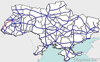
H09 is a national road (H-Highway) in Lviv Oblast, Ivano-Frankivsk Oblast and Zakarpattia Oblast, Ukraine. It runs north-south and connects Mukachevo with Lviv.

H05 is a regional road (H-Highway) in Crimea, Ukraine. It runs north-south and connects Krasnoperekopsk with Simferopol. Since the 2014 annexation of Crimea by the Russian Federation, the route was given another code 35K-001.

H06 is a regional road (H-Highway) in Crimea and Sevastopol. It runs northeast-south-southwest and connects Simferopol with Sevastopol. Since the 2014 annexation of Crimea by the Russian Federation, the route was given another code 35P-001 and 67P-1.

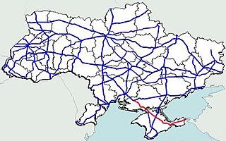
H19 is a regional road (H-Highway) in Crimea and Sevastopol, Ukraine. It is a western part of the so-called Yuzhnoberezhne shose. It runs east-west and connects Yalta with Sevastopol. Since the 2014 annexation of Crimea by the Russian Federation, the route was given another code 35K-002 and 67K-1.
P61 is a regional Ukraine road (P-highway) in Sumy Oblast, Ukraine, running mainly west-east and connecting Baturyn with Sumy in a more or less straight line. It begins at Highway M01/European route E101 and passes through Mytchenky, Krasne, Popivka, Konotop, Simyanivka, Dubovyazivka, Krasne, Chernecha Sloboda, Terny, Bobryk, Tuchne, Mykolaivka, Stepanivka, and ends in Sumy at Stepana Bandera Street and Illinska Street. There is also a branch road starting at Highway M03/European route E101 to Hetman's Capital National Park.