
European route E 58 is a road part of the International E-road network. It begins in Vienna, Austria and ends in Rostov-na-Donu, Russia. It is approximately 2,200 km (1,400 mi) long.

Highway M05 is a state international highway in Ukraine connecting the two largest cities: Kyiv and Odessa.

M01 is a Ukraine international highway (M-highway) that stretches from the state capital, Kyiv, to the northern border with Belarus.
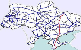
State highways in Ukraine are subdivided into three categories: international (M-network), national (H-network), and regional (P-network). The letter's indexes are in Cyrillic, standing for their respective abbreviations in Ukrainian.

Highway M02 is a Ukraine international highway (M-highway) connecting the M01 near Kipti with Bachivsk on the border with Russia, where it continues as the M3 to Moscow. The entire route is part of European route E101 and the section from Hlukhiv to the Russian border is part of European route E391.

Highway M03 is a Ukrainian international highway (M-highway) connecting Kyiv with Dovzhansky on the border with Russia, where it continues into Russia as the A270. It is part of European route E40 from Kyiv to Debaltseve at which it is part of European route E50 to the border with Russia. At 844 km (524 mi), the M03 is the longest international state highway in Ukraine.

Highway M06 is a Ukrainian international highway (M-highway) connecting Kyiv to the Hungarian border near Chop, where it continues as Hungarian main road 4 to Záhony and Budapest.

Highway M09 is a Ukrainian international highway (M-highway) which is part of the Warsaw - Lviv route. It starts as a split-off from the M12 near Ternopil, runs through Lviv, then turns north and heads towards the border with Poland. The highway terminates at the border checkpoint Rava-Ruska. Across the Polish border it continues as National Road 17 (DK17). The entire route is part of European route E372.

M12 was a Ukrainian international highway (M-highway) connecting Lviv Oblast to Central Ukraine, where after crossing the Dnieper it continued further as the M04. On 28 April 2021, the M12 was decommissioned and merged with the M04 to form the new M30.
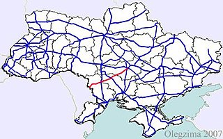
M13 is a Ukrainian international highway (M-highway) connecting Kropyvnytskyi to the border with Moldova, where before crossing the Dniester it heads towards Chişinău as the M21. The entire route is part of European route E584.

Highway M14 is a Ukrainian international highway (M-highway) connecting Odessa to the Russian border east of Mariupol, where it continues into Russia as the A280.

Highway M23 is one of the shortest Ukrainian international highway (M-highway) which connects Berehove with Khust and runs in the southern portion of the region next to the Hungarian and Romanian borders. From Berehove to the little settlement of Vylok the M23 is part of European route E58 and European route E81 which drift of towards the Romanian border at the border checkpoint Okli on a regional route.
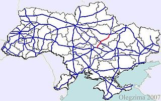
Highway M22 is a Ukrainian international highway (M-highway) which connects Oleksandriia, Kremenchuk, and Poltava across Dnieper river. The highway also connects two major transnational corridors that run along European route E50 and European route E40. Along with the M13, the M22 composes the Ukrainian portion of European route E584 that also runs from Kropyvnytskyi to the Moldovan border onto Chişinău.
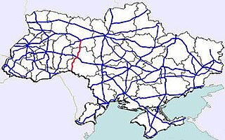
M21 is a Ukrainian international highway (M-highway) which connects Zhytomyr and Vinnytsia to the border with Moldova. The highway also connects two major transnational corridors, Pan-European Corridor IX and the transportation corridor "Europe-Asia". The entire route is part of European route E583. The section from Zhytomyr to the Belorussian border was previously P28.
Highway M15 is a Ukrainian international highway (M-highway) connecting Odessa to Reni. The entire route is part of European route E87. The highway is also known as the highway Odesa–Reni.
Highway M18 is a Ukrainian international highway (M-highway) connecting Kharkiv to the southern coast of Crimea in Yalta. The highway is also has an alternative route (M29) which runs parallel and designed as an expressway between Kharkiv and Novomoskovsk. The section from Novomoskovsk to Yalta is part of European route E105. The section from Kharkiv to Krasnohrad was previously P51.

Highway M19 is a Ukrainian international highway (M-highway) that completely corresponds to whole length of European route E85 that runs through Ukraine.

European route E 581 is a European B class road in Romania, Moldova and Ukraine.

Currently, there are three defined types of public roads in the Republic of Moldova:
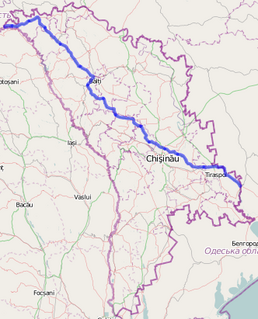
The M14 highway, sometimes referred to as the M5, is the longest road in Moldova, with a length of 370 km (230 mi) running from the north to the south-east. Having national road status, it is also one of the most important routes as it provides access to the three largest cities of Moldova within its internationally recognized borders: Chișinău, Tiraspol and Bălți. It forms part of the European routes E58, E581 and E583 of the International E-road network.

