This is a list of dams and reservoirs that are located in the Indian state of Karnataka. [1] [2]

Krishna Raja Sagara, also popularly known as KRS, is a lake and the dam that creates it. They are close to the settlement of Krishna Raja Sagara in the Indian State of Karnataka. The gravity dam made of surki mortar is below the confluence of river Kaveri with its tributaries Hemavati and Lakshmana Tirtha, in the district of Mandya.

The Mettur Dam is one of the largest dams in India and also the largest in Tamil Nadu, located across the river Kaveri where it enters the plains. Built in 1934, it took 9 years to complete. Maximum height and width of the dam are 214 and 171 feet, respectively. The dam receives inflows from its own catchment area, Kabini Dam and Krishna Raja Sagara Dams located in Karnataka. There is a park at the base of the dam called Ellis Park maintained by the Tamil Nadu Public Works Department. It provides irrigation and drinking water facilities for more than 12 districts of Tamil Nadu and hence is revered as the life and livelihood-giving asset of Tamil Nadu.
The Upper Krishna Project (UKP) is an irrigation project across the Krishna River to provide irrigation to the drought-prone areas of Vijayapura district, Karnataka, Bagalkot, Kalburgi, Yadgir and Raichur districts in the state of Karnataka in south India. The project had been designed by the Government of Karnataka to irrigate 1,536,000 acres of land (6,220 km2).

Karnataka, the sixth largest state in India, has been ranked as the third most popular state in the country for tourism in 2014. It is home to 507 of the 3600 centrally protected monuments in India, second only to Uttar Pradesh. The State Directorate of Archaeology and Museums protects an additional 752 monuments and another 25,000 monuments are yet to receive protection.

Kudalasangama in India is an important centre of pilgrimage for Lingayats. It is located about 15 kilometres (9.3 mi) from the Almatti Dam in Bagalkote district of Karnataka state. The Krishna and Malaprabha River rivers merge here and flow east towards Srisailam Andhra Pradesh. The Aikya Mantapa or the holy Samādhi of Basavanna, the founder of the Lingayatism along with Linga, which is believed to be self-born (Swayambhu), is here. The Kudala Sangama Development Board takes care of the maintenance and development.

The Indian State of Karnataka is located between 11°30' North and 18°30' North latitudes and between 74° East and 78°30' East longitude.It is situated on a tableland where the Western Ghats and Eastern Ghats converge into the complex, in the western part of the Deccan Peninsular region of India. The State is bounded by Maharashtra and Goa States in the north and northwest; by the Lakshadweep Sea in the west; by Kerala in the south-west and Tamil Nadu in the south and south-east, Andhra Pradesh in the south-east and east and Telangana in the north-east. Karnataka extends to about 850 km (530 mi) from north to south and about 450 km (280 mi) from east to west.

The Lal Bahadur Shastri Dam is also known as Almatti Dam is a hydroelectric project on the Krishna River in North Karnataka, India which was completed in July 2005. The target annual electric output of the dam is 560 MU.
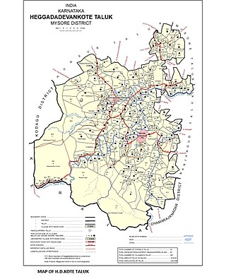
Sargur, is a small town located about 80 km from the town of Chamarajanagar And a Taluk of Mysore district of Karnataka, India. H D Kote (Heggadadevanakote) is about 12 km north of Sargur. It is 55 km from the city of Mysore. Bangalore International Airport is 200 km away. To be more elaborate, Sargur is 33.8 km from Nanjangud town (Karnataka), 35.1 km from Gundlupet town (Karnataka), 137.8 km from Udagamandalam town (Ooty) Valley and 38.8 km from Hunsur town (Karnataka).
Narayanpur or Narayanapur may refer to:

Naviluteertha is a village in Savadatti taluk of Belagavi district, Karnataka. It is a well-known picnic spot. The place derives its name as so many peafowls are found here. It has a Dam that was built in 1974 across Malaprabha river. This dam is the shortest dam in Karnataka with a height of 155 m and 41 m length with four gates.
Araladinni is a village in the southern state of Karnataka, India. It is located in the Basavana Bagevadi taluk of Bijapur district in Karnataka. It is 1 kilometer from Almatti Dam and 5 kilometer from Nidagundi. It has a good road and railway connectivity. National Highway 13 and Almatti Railway Station are less than 5 kilometers distance from Araladinni. Some of the famous places near by are Kudalasangama, Yalagur, Almatti Dam, Basavana Bagevadi.
Renuka Sagara, also known as Malaprabha reservoir and Navilutheertha reservoir, is a dam and impounding reservoir constructed across the Malaprabha River in the Krishna River basin. It is situated at Navilatirtha village in Savadatti Taluk Taluk of Belgaum district in North Karnataka, India. The dam is 43.13 metres high and has 4 vertical crest gates; it impounds a large reservoir with a gross surface area of 54.97 square kilometres, and storage capacity of 37.73 thousand million cubic feet. It is an earthen and masonry dam which caters to the Irrigation needs for over 540,000 acres, and hydroelectric power generation.
Shanthi Sagara, also called Sulekere, is the second largest built lake in Asia. It is located at Sulekere of Nallur Channagiri taluka of Davanagere District in Karnataka state of India.

The Tungabhadra Dam, also known as Pampa Sagar, is a water reservoir constructed across the Tungabhadra River in the city of Hosapete in Vijayanagara district, Karnataka, India. It is a multipurpose dam serving irrigation, electricity generation, flood control, etc. for the state. It is one of the only two non-cement dams in India, the other being the Mullaperiyar Dam in Kerala. The dam is built of surki mortar, a combination of mud and limestone, commonly used at the time of its construction.

Basava Sagar Dam, previously known as Narayanpura Dam, is a dam constructed across the Krishna River at Yadgir District, Karnataka State, India. The reservoir that it impounds is known as Basava Sagar, and has a total storage capacity of 37.965 tmcft (1.075 km3), with 30.5 tmcft (0.85 km3) live storage. The full reservoir level is 492.25 m MSL and the minimum draw down level is 481.6 m MSL. It was a single purpose project meant only for irrigation, but downstream electrical generation and drinking water considerations enter into its management. The dam is 29 meters high and over 10.637 kilometres (6.610 mi) long, and has 30 gates for water release. 22 Spillway Gates are present in the Dam It took Rs. 50.48 crore to complete.

The following outline is provided as an overview of and topical guide to Karnataka:

Kapil Mohan is a 1990 batch Indian civil servant. He has served in the Ministry of Power for the Government of India during which he implemented the Restructured Accelerated Power Development & Reforms Program (RAPDRP) and the Rajiv Gandhi Grameen Vidyutikaran Yojana (RGGVY).
Markandeya is a river of southern India. It rises in the Bailur in Khanapur Taluk of Belgaum district, Karnataka state, enters Belagavi taluk on southern side and flows towards western side of the Belagavi city and flows 66 kilometres (41 mi) in Belgaum district forming beautiful Godchinamalaki Falls before reaching its confluence into the Ghataprabha River at Gokak about 60 kilometres (37 mi) from Belgaum.
Maladkal is a village in Karnataka state, comes under Raichur District, Devadurga Taluk and Gabbur hobli. Maladkal lies in northern part of Karnataka(Kalyana Karnataka Division). Maladkal shares its boundary with Gabbur, Ramadurga, Jagatakal, N Ganekal, Maseedpur and Atnur. Maladakal is one of the Gram Panchayat in Raichur District.
{{cite web}}: CS1 maint: archived copy as title (link)