Torhouse

Last updated

Torhouse Stone Circle
Stone Circle - geograph.org.uk - 2979829.jpg
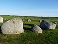
Torhousekie stone circle
Dumfries and Galloway UK location map.svg
Archaeological site icon (red).svg
Shown within Dumfries and Galloway
Alternative nameTorhousekie
Location Galloway
Coordinates 54°52′39″N4°31′22″W / 54.877472°N 4.522639°W / 54.877472; -4.522639
Type Stone circle
History
Periods Neolithic / Bronze Age
Site notes
Ownership Historic Environment Scotland
Public accessYes
Official nameTorhouse Stone Circle
Reference no. SM90304

The Standing Stones of Torhouse (also Torhousekie) are a stone circle of nineteen granite boulders on the land of Torhouse, three miles west of Wigtown, Scotland.

Contents

Description

The stone circle consists of nineteen granite boulders set on a slightly raised platform. [1] The stones have a height ranging from about 0.6 metres to 1.5 metres and are arranged in a circle with a diameter of about 22 metres. [1] The larger stones, over 1 metre high, are on the southeast side. [2]

Three upright boulders stand in a line near the centre of the circle. [3] The direction of the line of the three central stones is northeast to southwest. [1]

Two stones stand 40 metres to the south-southeast of the stone circle, one large and the other small, and there is a stone row of three stones 130 metres to the east. [2] There are also surviving remains of several burial cairns, and history records others long removed to build field dykes. [2]

The stone circle has not yet been archaeologically excavated. It probably dates to the Neolithic period or the Bronze Age. [1] [2] The Torhouse Stones are in the care of Historic Environment Scotland as a scheduled monument. [2]

In folklore

Local tradition maintains that the three large stones in the center of the circle contained the tomb of Galdus, a mythical Scottish king. [2] [4] A similar story is told about one of the tombs at Cairnholy, also in Galloway. [5]

In the dyke on the south side of the road is a stone with a deep cavity which according to tradition, "the knowing never pass without depositing therein some pebble or gift to pass in peace". [6]

Related Research Articles

Chambered cairn Burial monument (Usually Neolithic)

A chambered cairn is a burial monument, usually constructed during the Neolithic, consisting of a sizeable chamber around and over which a cairn of stones was constructed. Some chambered cairns are also passage-graves. They are found throughout Britain and Ireland, with the largest number in Scotland.

Ring of Brodgar A neolithic stone circle in Orkney, Scotland

The Ring of Brodgar is a Neolithic henge and stone circle about 6 miles north-east of Stromness on Mainland, the largest island in Orkney, Scotland. It is part of the UNESCO World Heritage Site known as the Heart of Neolithic Orkney.

Mên-an-Tol Neolithic standing stones in Cornwall, England

The Mên-an-Tol is a small formation of standing stones in Cornwall, UK. It is about three miles northwest of Madron. It is also known locally as the "Crick Stone".

Court cairn Type of chamber tomb found in northwestern and northern Ireland, and southwest Scotland

The court cairn or court tomb is a megalithic type of chambered cairn or gallery grave. During the period, 3900–3500 BCE, more than 390 court cairns were constructed in Ireland and over 100 in southwest Scotland. The neolithic monuments are identified by an uncovered courtyard connected to one or more roofed and partitioned burial chambers. Many monuments were built in multiple phases in both Ireland and Scotland and later re-used in the Early Bronze Age.

Beaghmore Early Bronze Age complex in Northern Ireland

Beaghmore is a complex of early Bronze Age megalithic features, stone circles and cairns, 8.5 miles north west of Cookstown, County Tyrone in Northern Ireland, on the south-east edge of the Sperrin Mountains.

Merrick (Galloway) Mountain in the Range of the Awful

The Merrick, or simply Merrick, is a mountain in the Range of the Awful Hand, a sub-range of the Galloway Hills range, part of the Southern Uplands of Scotland. The summit elevation is 843 metres, making it the highest mountain in the Southern Uplands and southern Scotland.

Carrowmore

Carrowmore is a large group of megalithic monuments on the Cúil Iorra Peninsula to the west of Sligo, Ireland. They were built in the 4th millennium BCE, during the Neolithic era. There are thirty surviving tombs, making Carrowmore one of the largest clusters of megalithic tombs in Ireland. It is considered one of the 'big four' along with Carrowkeel, Loughcrew and Brú na Bóinne. Carrowmore is the heart of an ancient ritual landscape which is dominated by the mountain of Knocknarea to the west. It is a protected National Monument.

New Luce is a civil parish in Dumfries and Galloway, south-west Scotland. It lies in the traditional county of Wigtownshire, and is about 10 miles (16 km) in length and 5 miles (8.0 km) in breath, being the upper part of the original Glenluce Parish. New Luce is shown as a civil parish on John Ainslie's county map of 1782.

Callanish Stones Neolithic standing stones in the Scottish Outer Hebrides

The Callanish Stones are an arrangement of standing stones placed in a cruciform pattern with a central stone circle. They were erected in the late Neolithic era, and were a focus for ritual activity during the Bronze Age. They are near the village of Callanish on the west coast of Lewis in the Outer Hebrides, Scotland.

There are many large stones of Scotland of cultural and historical interest, notably the distinctive Pictish stones, but also the other types discussed below.

The Merry Maidens Late Neolithic stone circle in Cornwall, England

The Merry Maidens, also known as Dawn's Men is a late neolithic stone circle located 2 miles (3 km) to the south of the village of St Buryan, in Cornwall, United Kingdom. A pair of standing stones, The Pipers is associated both geographically and in legend.

Cairnsmore of Fleet

Cairnsmore of Fleet is an isolated mountain in the Southern Uplands of Scotland. The mountain forms an unafforested granite massif, whose highest point is about 10 kilometres (6.2 mi) east of Newton Stewart. It is the highest of the "Solway Hills" sub-range, and the southernmost of Scotland's 219 Grahams, thus making it, or rather its subsidiary top, Knee of Cairnsmore, the most southerly mountain in Scotland. The view to the south takes in the Cree Estuary and Wigtown Bay, and extends as far as the Lake District, the Isle of Man and Snowdonia. The highest summits of the Galloway Hills can be seen to the north, and Ireland is in the view to the west.

Beltany stone circle Bronze Age stone circle

Beltany is a Bronze Age stone circle just south of Raphoe town in County Donegal, Ireland. It dates from circa 2100-700 BC. There is evidence that it may also have been the sacred site of Neolithic monuments, possibly early passage tombs. It overlooks the now destroyed passage tomb complex at Kilmonaster and Beltany is dominated by Croghan Hill to the east on the summit of which there sits a Neolithic mound most likely a passage tomb.

Cruggleton Castle Castle in Scotland

Cruggleton Castle is a multi-period archaeological site on the coast of the Machars, in the historical county of Wigtownshire in south-west Scotland. It is located at Cruggleton Point, around 4.5 kilometres (2.8 mi) east of Whithorn and 6 kilometres (3.7 mi) south-east of Sorbie. Excavations in the 1970s and 1980s revealed several periods of use, from the 1st century AD to the 17th century. The first stone tower was built in the 13th century, on an earlier motte.

Easter Aquhorthies stone circle Well-preserved recumbent stone circle in north-east Scotland

Easter Aquhorthies stone circle, located near Inverurie in north-east Scotland, is one of the best-preserved examples of a recumbent stone circle, and one of the few that still have their full complement of stones and the only one that has all its stones still standing without having been re-erected. It stands on a gentle hill slope about 1 mile (1.6 km) west of Inverurie, and consists of a ring of nine stones, eight of which are grey granite and one red jasper. Two more grey granite stones flank a recumbent of red granite flecked with crystals and lines of quartz. The circle is particularly notable for its builders' use of polychromy in the stones, with the reddish ones situated on the SSW side and the grey ones opposite. The discovery of a possible cist covered by a capstone at the centre of the circle indicates that there may once have been a cairn there, but only a conspicuous bump now remains.

Prehistoric Orkney Overview of the prehistoric period on the Orkney Islands, Scotland

Prehistoric Orkney refers only to the prehistory of the Orkney archipelago of Scotland that begins with human occupation. Although some records referring to Orkney survive that were written during the Roman invasions of Scotland, “prehistory” in northern Scotland is defined as lasting until the start of Scotland's Early Historic Period.

Machrie Moor Stone Circles

Machrie Moor Stone Circles is the collective name for six stone circles visible on Machrie Moor near the settlement of Machrie on the Isle of Arran, Scotland.

Cairnholy Archaeological site in Scotland

Cairnholy is the site of two Neolithic chambered tombs of the Clyde type. It is located 4 kilometres east of the village of Carsluith in Dumfries and Galloway, Scotland. The tombs are scheduled monuments in the care of Historic Scotland.

Wrens Egg

The Wren's Egg is the name given to a set of late Neolithic or Bronze Age stone monuments in the parish of Glasserton, Wigtownshire, Dumfries and Galloway. The site comprises two pairs of standing stones to the north and south of a large glacial erratic, the Wren's Egg itself. It was one of the first monuments taken into state care after the Ancient Monuments Act passed in 1882.

Tomnaverie stone circle Recumbent stone circle in Aberdeenshire

Tomnaverie stone circle is a recumbent stone circle set on the top of a small hill in lowland northeast Scotland. Construction started from about 2500 BC, in the Bronze Age, to produce a monument of thirteen granite stones including a massive 6.5-ton recumbent stone lying on its side along the southwest of the circle's perimeter. Within the 17-metre (56 ft) circle are kerb stones encircling a low 15-metre (49 ft) ring cairn but the cairn itself no longer exists.

References

  1. 1 2 3 4 Historic Environment Scotland. "Torhouse Stone Circle (SM90304)" . Retrieved 29 March 2019.
  2. 1 2 3 4 5 6 "Torhouse Stone Circle: History". Historic Environment Scotland. Retrieved 29 March 2019.
  3. Historic Environment Scotland. "Torhousekie (62843)". Canmore . Retrieved 14 August 2015.
  4. MacLeod, I. F. (1986). Discovering Galloway. John Donald. p. 213.
  5. "Cairn Holy Chambered Cairns". Historic Environemt Scotland. Retrieved 29 March 2019.
  6. Carroll, David (2013). Dumfries & Galloway Curiosities. The History Press. ISBN   075248950X.

Coordinates: 54°52′38.90″N4°31′21.50″W / 54.8774722°N 4.5226389°W / 54.8774722; -4.5226389