It has been suggested that this article be merged into History of Austin, Texas . (Discuss) Proposed since September 2021. |
Waterloo was the original name for the city of Austin, Texas, located in Travis County in the central part of the state. [1]
It has been suggested that this article be merged into History of Austin, Texas . (Discuss) Proposed since September 2021. |
Waterloo was the original name for the city of Austin, Texas, located in Travis County in the central part of the state. [1]
After Republic of Texas Vice President Mirabeau B. Lamar visited the area during a buffalo-hunting expedition between 1837 and 1838,[ citation needed ] he proposed that the republic's capital, then located in Houston, be relocated to an area situated on the north bank of the Colorado River near the present-day Ann W. Richards Congress Avenue Bridge in what is now central Austin. In 1839, the site was officially chosen as the seventh and final location for the capital of the Republic of Texas. It was incorporated under the name "Waterloo". Shortly thereafter, the name was changed to Austin in honor of Stephen F. Austin, the "Father of Texas" and the republic's first secretary of state. [1]

Austin is the capital city of the U.S. state of Texas, as well as the seat and largest city of Travis County, with portions extending into Hays and Williamson counties. Incorporated on December 27, 1839, it is the 11th-most populous city in the United States, the fourth-most-populous city in Texas, the second-most-populous state capital city after Phoenix, Arizona, and the most populous state capital that is not also the most populous city in its state. It has been one of the fastest growing large cities in the United States since 2010. Austin is the southernmost state capital in the contiguous United States and is considered a "Beta −" global city as categorized by the Globalization and World Cities Research Network.

Travis County is located in south central Texas. As of the 2020 census, the population was 1,290,188. It is the fifth-most populous county in Texas. Its county seat is Austin, the capital of Texas. The county was established in 1840 and is named in honor of William Barret Travis, the commander of the Republic of Texas forces at the Battle of the Alamo. Travis County is part of the Austin–Round Rock Metropolitan Statistical Area. It is located along the Balcones Fault, the boundary between the Edwards Plateau to the west and the Blackland Prairie to the east.
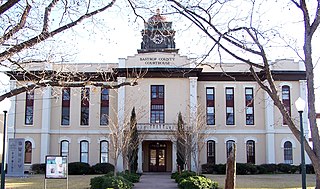
Bastrop County is located in the U.S. state of Texas. As of the 2010 census, the population was 74,171. Its county seat is Bastrop.

Elgin is a city in Bastrop and Travis Counties in the U.S. state of Texas. The population was 8,135 at the 2010 census. The city is a suburb of Austin, and is part of the Greater Austin metropolitan area. Elgin is also known as the Sausage Capital of Texas and the Brick Capital of the Southwest, due to the presence of three operating brickyards in the mid-20th century.

Hippie Hollow Park is a park located on the shore of Lake Travis in northwest Austin. It is the only legally recognized clothing-optional public park in the State of Texas. Though the land is owned by the Lower Colorado River Authority, it is leased to Travis County, whose Parks Department has administered the park since 1985. Sometimes erroneously labeled as a beach, the park actually sits on a somewhat steep slope above Lake Travis with limestone steps that can be quite rugged in some spots. Depending on the water level of the lake, access to the water may require some rock climbing.

Washington-on-the-Brazos is an unincorporated community along the Brazos River in Washington County, Texas, United States. The town is best known for being the site of the Convention of 1836 and the signing of the Texas Declaration of Independence. As of 2009, the estimated population was 265.

The following is an alphabetical list of articles related to the U.S. state of Texas.

Manchaca is an unincorporated community and census-designated place (CDP) in Travis County, Texas, United States. It is located 10 miles (16 km) southwest of downtown Austin. This was a new CDP for the 2010 census with a population of 1,133.

The Austin Community College District (ACC) is a public community college system serving the Austin, Texas, metropolitan area and surrounding Central Texas communities. The college maintains numerous campuses, centers, and distance learning options to serve about 100,000 students in academic, continuing education and adult education programs.

Mount Bonnell, also known as Covert Park, is a prominent point alongside the Lake Austin portion of the Colorado River in Austin, Texas. It has been a popular tourist destination since the 1850s. The mount provides a vista for viewing the city of Austin, Lake Austin, and the surrounding hills. It was designated a Recorded Texas Historic Landmark in 1969, bearing Marker number 6473, and was listed on the National Register of Historic Places in 2015.
KLRU, virtual channel 18, branded on-air as Austin PBS, is a PBS member television station licensed to Austin, Texas, United States. The station is owned by the Capital of Texas Public Telecommunications Council. KLRU's studios are located on Guadalupe and Dean Keeton streets on rented space on the campus of University of Texas at Austin, although the station has no other direct affiliation with the university. Its transmitter is located in the West Austin Antenna Farm in unincorporated Travis County. In addition to airing program content from PBS, it produces original programming including the national music series Austin City Limits.
Del Valle is an airport-defined edge city of Austin and part of the Austin–Round Rock–San Marcos Metropolitan Statistical Area. It is founded upon the 19th-century Santiago Del Valle leagues, the largest granted land parcel in Travis County.

The recorded history of Austin, Texas, began in the 1830s when Anglo-American settlers arrived in Central Texas. In 1837 settlers founded the village of Waterloo on the banks of the Colorado River, the first permanent settlement in the area. By 1839, Waterloo would adopt the name Austin and become the capital of the Republic of Texas.

Austin–Round Rock–San Marcos is a five-county metropolitan area in the U.S. state of Texas, as defined by the Office of Management and Budget. The metropolitan area is situated in Central Texas on the eastern edge of the American Southwest, and borders Greater San Antonio to the south.

Oak Hill is an unincorporated community and collection of neighborhoods located in southwest Austin, Texas.

Moore's Crossing Historic District is a community located in rural Travis County nine miles southeast of Austin, Texas near the Austin–Bergstrom International Airport.

Downtown Austin is the central business district of Austin, Texas. Downtown is located on the north bank of the Colorado River. The approximate borders of Downtown include Lamar Boulevard to the west, Martin Luther King Jr. Boulevard and the University of Texas at Austin to the north, Interstate 35 to the east, and Lady Bird Lake to the south.

Central Texas is a region in the U.S. state of Texas surrounding Austin and roughly bordered by San Saba to Bryan and San Marcos to Hillsboro. Central Texas overlaps with and includes part of the Texas Hill Country and corresponds to a physiographic section designation within the Edwards Plateau, in a geographic context.

Littig is a small unincorporated community in eastern Travis County, Texas, United States established in 1883. Littig is on the Southern Pacific line two miles (3 km) south of U.S. Highway 290 and eighteen miles (29 km) northeast of the state capital, Austin, in eastern Travis County. It began with one of the oldest black communities in the state, and now has a diverse population. The Littig Cemetery is located nearby.

The 1839 Austin city plan is the original city plan for the development of Austin, Texas, which established the grid plan for what is now downtown Austin. It was commissioned in 1839 by the government of the Republic of Texas and developed by Edwin Waller, a Texian revolutionary and politician who would later become Austin's first mayor.
Municipalities and communities of Travis County, Texas, United States | ||
|---|---|---|
| Cities |  | |
| Villages | ||
| CDPs | ||
| Other unincorporated communities | ||
| Footnotes | ‡This populated place also has portions in an adjacent county or counties | |
| General | |
|---|---|
| National libraries | |
| | This article about a location in Travis County, Texas is a stub. You can help Wikipedia by expanding it. |