Mandeville, Louisiana

Last updated

Mandeville, Louisiana
City of Mandeville
Mandeville Maxens exterior.JPG
St. Tammany Parish Louisiana Incorporated and Unincorporated areas Mandeville Highlighted.svg
Location of Mandeville in St. Tammany Parish, Louisiana
Louisiana in United States (US48).svg
Location of Louisiana in the contiguous United States
Coordinates: 30°22′09″N90°04′41″W / 30.36917°N 90.07806°W / 30.36917; -90.07806
Country United States
State Louisiana
Parish St. Tammany
Incorporated1840
Government
  MayorClay Madden (R)
Area
[1]
  Total7.29 sq mi (18.87 km2)
  Land7.12 sq mi (18.44 km2)
  Water0.16 sq mi (0.42 km2)
Elevation
7 ft (2 m)
Population
 (2020)
  Total13,192
  Density1,852.29/sq mi (715.21/km2)
Time zone UTC-6 (CST)
  Summer (DST) UTC-5 (CDT)
ZIP codes
70448, 70471, 70433
Area code 985
FIPS code 22-48225
Website www.cityofmandeville.com

Mandeville is a city in St. Tammany Parish, Louisiana, United States. Its population was 11,560 at the 2010 U.S. census, [2] and 13,192 at the 2020 United States census. [3] Mandeville is located on the north shore of Lake Pontchartrain, south of Interstate 12. It is across the lake from the city of New Orleans and its southshore suburbs. It is part of the New OrleansMetairieKenner metropolitan area.

Contents

History

Ruby's Roadhouse Mandeville Rubys Front.JPG
Ruby's Roadhouse

Mandeville means "big farm" (from Magna Villa) in medieval Norman French. The town's name specifically comes from its founder, Bernard Xavier de Marigny de Mandeville.[ citation needed ]

The city of Mandeville was founded in 1834 by Bernard Xavier de Marigny de Mandeville (1785-1868). [4] The Marigny family was a prominent family of Louisiana, owning nearly a third of the city of New Orleans. The area had long been agricultural land when the town of Mandeville was laid out in 1834 by developer Bernard Xavier de Marigny de Mandeville, more often known as Bernard de Marigny. In 1840, Mandeville was incorporated as a town. It became a popular summer destination for well-to-do New Orleanians wishing to escape the city's heat.

In the mid-19th century, regular daily steamboat traffic between New Orleans and Mandeville began, and by the end of the Victorian era, it had become a popular weekend destination of the New Orleans middle class, as well. Bands played music on the ships going across the lake and at pavilions and dance halls in Mandeville, and the town became one of the first places where the new "jazz" music was heard outside of New Orleans. Bunk Johnson, Buddy Petit, Papa Celestin, George Lewis, Kid Ory, Edmond Hall, Chester Zardis, and many other early jazz artists regularly played in Mandeville.

In the late 19th century, Mandeville was home of the Harvey School (Mandeville), a college preparatory institution. [5]

Two buildings from early jazz history still stand in Mandeville. Ruby's Roadhouse has been in continuous operation since the 1920s (formerly Buck's Brown Derby and Ruby's Rendezvous) and is still a popular bar and live music venue today. The Dew Drop Social and Benevolent Hall, listed on the National Register of Historic Places, opened in January 1895. For years, the hall hosted some of the jazz greats and was reopened in 2000 as the Dew Drop Jazz and Social Hall, a live jazz venue. (This was one of the earliest "Dew Drop" dance halls; venues across the South were similarly named, including the club in New Orleans where Little Richard got his start.)

In 1956, the first span of the Lake Pontchartrain Causeway opened to automobile traffic. A second span was added in 1969. The new road spurred the growth of Mandeville and the surrounding area as a suburban commuter community for people working in New Orleans. This trend increased in the 1980s and 1990s, further integrating Mandeville into the greater New Orleans metropolitan area.

Girod Street during the Hurricane Ike flood in 2008 Hurricane Ike - Old Mandeville (3).jpg
Girod Street during the Hurricane Ike flood in 2008

Mandeville was affected by Hurricane Katrina's storm surge on August 29, 2005, and received water and wind damage. Parts of the city also experienced less dramatic flooding when Lake Pontchartrain overflowed its banks due to Hurricane Ike in 2008. By 2009, most of the reconstruction from Katrina was completed. Many homes and businesses in areas that experienced flooding have been elevated.

Geography

According to the United States Census Bureau, the city has a total area of 6.8 square miles (17.7 km2), of which 0.12 square miles (0.3 km2), or 1.55%, is covered by water. [6]

The Tchefuncte River flows through Madisonville, and a manned swing bridge connects Mandeville to Madisonville.

Demographics

Historical population
CensusPop.Note
1870 541
1880 75339.2%
1890 1,01234.4%
1900 1,0291.7%
1910 1,16613.3%
1920 1,130−3.1%
1930 1,069−5.4%
1940 1,32624.0%
1950 1,3683.2%
1960 1,74027.2%
1970 2,57147.8%
1980 6,076136.3%
1990 7,08316.6%
2000 10,48948.1%
2010 11,56010.2%
2020 13,19214.1%
U.S. Decennial Census [7]

The 2020 census by the United States Census Bureau determined 13,192 people lived in Mandeville. [3] The racial and ethnic makeup at the 2019 American Community Survey was 90.2% non-Hispanic white, 2.8% Black and African American, 2.8% Asian, 0.2% some other race, 0.4% two or more races, and 3.6% Hispanic and Latin American of any race. [8]

At the 2000 United States census, [9] 10,489 people, 4,204 households, and 2,724 families were residing in the city. The population density was 1,543.1 inhabitants per square mile (595.8/km2). There were 4,669 housing units with an average density of 686.9/sq mi (265.1/km2). The racial makeup of the city was 92.15% White, 4.79% Black and African American, 0.31% Native American, 1.16% Asian, 0.06% Pacific Islander, 0.59% from other races, and 0.93% from two or more races. Hispanic or Latin American people of any race were 2.43% of the population.

In 2000, of the 4,204 households, 30.6% had children under 18 living with them, 50.6% were married couples living together, 10.8% had a female householder with no husband present, and 35.2% were not families. About 29.8% of all households were made up of individuals, and 11.4% had someone living alone who was 65 years of age or older. The average household size was 2.46, and the average family size was 3.11. In the city, the population was spread out, with 27.3% under the age of 18, 7.3% from 18 to 24, 28.9% from 25 to 44, 24.5% from 45 to 64, and 11.9% who were 65 years of age or older. The median age was 38 years. For every 100 females, there were approximately 89.2 males. For every 100 females age 18 and over, there were about 84.7 males. At the 2019 American Community Survey, the median age was 43.7 and 77.0% of the population were aged 18 and older; 18.3% of the population were aged 65 and older. [10]

In 2019, the median household income was $72,989 and males had a median income of $76,573 versus $50,707 for females. In 2000, median income for a household in the city was $52,500, and the median income for a family was $70,043. Males had a median income of $50,891 versus $30,554 for females. The per capita income for the city was $26,420. About 4.9% of families and 7.6% of the population were below the poverty line, including 7.1% of those under age 18 and 13.7% of those age 65 or over.

Arts and culture

Parks and recreation

Sunset Point Fisher's Pier Sunset Point Fisher's Pier & Park Mandeville by Tiffany Stockstill.jpg
Sunset Point Fisher's Pier

The city of Mandeville has several parks: Paul Cordez Park, Lakefront Gazebo, Sunset Point, and Tyler Thomas Park. [13]

Sunset Point Fishing Pier and Park extends over 400 feet (120 m) onto Lake Pontchartrain. [14]

Education

Primary and secondary schools

Public schools

Mandeville High School Mandeville High School.jpg
Mandeville High School

St. Tammany Parish Public Schools operates public schools serving the city. [15]

Elementary schools with sections of Mandeville include: [16]

  • Mandeville Elementary School (grades Pre-Kindergarten-3, central Mandeville) [17]
  • Pontchartrain Elementary (grades Pre-Kindergarten-3, western Mandeville) [18]
  • Woodlake Elementary (grades Pre-Kindergarten-3, eastern Mandeville) [19]
  • Marigny Elementary (grades Pre-Kindergarten-1, a few blocks) [20]
  • Magnolia Trace Elementary (grades 2-3, a few blocks) [21]

Middle schools (grades 4-6) with sections of Mandeville include Tchefuncte Middle School (most of Mandeville), [22] Lake Harbor Middle School (parts of eastern and northern Mandeville), [23] and Mandeville Middle School (a few blocks of north and east Mandeville). [24]

For junior high school (grades 7-8), most of Mandeville is zoned to Mandeville Junior High School. [25] A few blocks in the north are zoned to Fontainebleau Junior High, [26] and a few blocks in the east side are zoned to Monteleone Junior High School. [27]

For high school (grades 9-12), most of Mandeville is zoned to Mandeville High School. [28] A few blocks in the north are zoned to Fontainebleau High School, [29] and a few blocks in the east are zoned to Lakeshore High School. [30]

Private schools

The Roman Catholic Archdiocese of New Orleans operates Catholic parochial schools:

  • Mary Queen of Peace School [31]
  • Our Lady of the Lake School [32]

Non-Catholic private schools include:

  • Cedarwood School - in the city limits [33]
  • Lake Castle Private School - northwest of Mandeville [34]

Public libraries

St. Tammany Parish Library operates the Mandeville Library. [35]

Community colleges

St. Tammany Parish is within the service areas of two community colleges: Northshore Technical Community College and Delgado Community College. [36]

Community Resources

Northlake Behavioral Health System is a mental-health facility in Mandeville, Louisiana.[ citation needed ]

Notable people

Mandeville is the hometown of Cajun fiddler and bandleader Amanda Shaw, the rock group 12 Stones, YouTube personality TJ Kirk, the post-hardcore band As Cities Burn, comedian Theo Von, Wilco bassist John Stirratt, and actor and environmentalist Ian Somerhalder. Actress Allison Scagliotti grew up in Mandeville. Willem McCormick lived here for a few years while writing music before moving to Los Angeles, as did former US soccer national team player Jason Kreis before entering MLS. Sirius XM's The Mike Church Show is broadcast from a studio in Mandeville five days per week by Mike Church, who is a native of the city. Singer/songwriter Lucinda Williams spent time in Mandeville as a child and noted the town in her song "Crescent City", which has been covered by others including Emmylou Harris. Former WWE wrestler, Brodus Clay has lived in the city of Mandeville since 2010. Former New Orleans Saints offensive lineman Jim Dombrowski lives in Mandeville. Former Saints wide receiver Rich Mauti lives in Mandeville, and his son, Saints linebacker Michael Mauti, is from Mandeville. [37]

Mandeville has an active political scene, with Eddie Price having been elected mayor for several terms commencing in 1996. He stepped down as mayor on October 9, 2009, and subsequently pleaded guilty to charges including tax evasion and depriving citizens of honest services through mail fraud. The city council then selected Edward "Bubby" Lyons as interim mayor. [38] [39] [40] [41] [42] White nationalist and white supremacist David Duke has a residence in Mandeville, and is a perennial candidate. His most notable electoral outcomes are his almost-wins for Senate in 1990 and Governor of Louisiana in 1991 and his successful bid for the Louisiana House of Representatives from 1989 to 1992.

Author Margaux Fragoso spent the final years of her life in Mandeville with her second husband, Tom O'Connor, and her daughter, Alicia McGowan, from her first marriage. [43]

Sister cities

Mandeville has one sister city, as designated by Sister Cities International:

Related Research Articles

<span class="mw-page-title-main">Interstate 12</span> Interstate in Louisiana

Interstate 12 (I-12) is an intrastate Interstate Highway located entirely within the US state of Louisiana. It spans a total of 85.59 miles (137.74 km) in an east–west direction from I-10 in Baton Rouge to an interchange with both I-10 and I-59 in Slidell. Along the way, it passes through the city of Hammond, where it intersects I-55 and US Route 51 (US 51). It also serves the cities of Ponchatoula and Denham Springs, as well as the St. Tammany Parish cities of Covington and Mandeville.

<span class="mw-page-title-main">St. Tammany Parish, Louisiana</span> Parish in Louisiana, United States

St. Tammany Parish is a parish located in the U.S. state of Louisiana named after Tamanend, the legendary Lenape Chief of Chiefs and the "Patron Saint of America." At the 2020 census, the population was 264,570, making it the fourth-most populous parish in Louisiana. The parish seat is Covington. The parish was founded in 1810.

<span class="mw-page-title-main">Jefferson Parish, Louisiana</span> Parish in Louisiana, United States

Jefferson Parish is a parish in the U.S. state of Louisiana. As of the 2020 census, the population was 440,781. Its parish seat is Gretna, its largest community is Metairie, and its largest incorporated city is Kenner. Jefferson Parish is included in the Greater New Orleans area.

<span class="mw-page-title-main">Metairie, Louisiana</span> Census-designated place in Louisiana, United States

Metairie is a census-designated place (CDP) in Jefferson Parish, Louisiana, United States, and is part of the New Orleans metropolitan area. With a population of 143,507 in 2020, Metairie is the largest community in Jefferson Parish and was the fifth-largest CDP in the United States. It is an unincorporated area that would have been Louisiana's fourth-largest city behind Shreveport if incorporated.

<span class="mw-page-title-main">Covington, Louisiana</span> City in Louisiana, United States

Covington is a city in, and the parish seat of, St. Tammany Parish, Louisiana, United States. The population was 11,564 at the 2020 United States census. It is located at a fork of the Bogue Falaya and the Tchefuncte River. Covington is part of the New Orleans–Metairie–Kenner metropolitan statistical area. Covington has played a large role in movie making over the past 20 years, featuring in over 30 films.

Eden Isle is a census-designated place (CDP) in St. Tammany Parish, Louisiana, United States, on the northeast shore of Lake Pontchartrain. The population was 7,041 at the 2010 census. It is part of the New Orleans–Metairie–Kenner Metropolitan Statistical Area. The area is a residential community with homes built on a system of canals connecting to eastern Lake Pontchartrain, which also includes businesses along the Interstate-10 corridor as well as restaurants and marina services within the residential section.

<span class="mw-page-title-main">Folsom, Louisiana</span> Village in Louisiana, United States

Folsom is a village in St. Tammany Parish, Louisiana, United States. The population was 716 at the 2010 census. The town is named after the wife of Grover Cleveland, Frances Folsom. It is part of the New Orleans–Metairie–Kenner Metropolitan Statistical Area.

<span class="mw-page-title-main">Lacombe, Louisiana</span> Census-designated place in Louisiana, United States

Lacombe is a census-designated place (CDP) in St. Tammany Parish, Louisiana, United States. The population was 8,679 at the 2010 census.

<span class="mw-page-title-main">Madisonville, Louisiana</span> Town in Louisiana, United States

Madisonville is a town in St. Tammany Parish in the U.S. state of Louisiana. The population was 748 at the 2010 U.S. census, and 857 at the 2020 U.S. population estimates program. It is part of the New Orleans–Metairie–Kenner metropolitan statistical area. The ZIP code is 70447.

<span class="mw-page-title-main">Slidell, Louisiana</span> City in Louisiana, United States

Slidell is a city on the northeast shore of Lake Pontchartrain in St. Tammany Parish, Louisiana, United States. The population was 28,781 at the 2020 census. It is part of the New Orleans−Metairie−Kenner metropolitan statistical area.

<span class="mw-page-title-main">Lake Pontchartrain</span> Estuary located in southeastern Louisiana, United States

Lake Pontchartrain is an estuary located in southeastern Louisiana in the United States. It covers an area of 630 square miles (1,600 km2) with an average depth of 12 to 14 feet. Some shipping channels are kept deeper through dredging. It is roughly oval in shape, about 40 miles (64 km) from west to east and 24 miles (39 km) from south to north.

<span class="mw-page-title-main">Faubourg Marigny</span> New Orleans neighborhood in Louisiana, United States

The Faubourg Marigny is a neighborhood of the city of New Orleans, Louisiana, United States.

<span class="mw-page-title-main">New Orleans metropolitan area</span> Metropolitan area

The New Orleans metropolitan area, designated the New Orleans–Metairie metropolitan statistical area by the U.S. Office of Management and Budget, or simply Greater New Orleans, is a metropolitan statistical area designated by the United States Census Bureau encompassing seven Louisiana parishes—the equivalent of counties in other U.S. states—centered on the city of New Orleans. The population of Greater New Orleans was 1,271,845 in 2020, up from 1,189,166 at the 2010 United States census. Greater New Orleans is the most populous metropolitan area in Louisiana, and the 45th most populous in the United States. According to 2017 census estimates, the broader New Orleans–Metairie–Slidell combined statistical area (CSA) had a population of 1,510,562.

<span class="mw-page-title-main">Florida Parishes</span> Region in Louisiana, United States

The Florida Parishes, on the east side of the Mississippi River—an area also known as the Northshore or Northlake region—are eight parishes in the southeastern portion of the U.S. state of Louisiana.

<span class="mw-page-title-main">Elysian Fields Avenue</span> Highway in Louisiana

Elysian Fields Avenue is a broad, straight avenue in New Orleans named after the Avenue des Champs-Élysées in Paris. It courses south to north from the Lower Mississippi River to Lake Pontchartrain, a distance of approximately 5 miles (8.0 km). The avenue intersects with Interstate 610, Interstate 10, and U.S. Highway 90, Gentilly Boulevard passing by Brother Martin High School. The part between North Claiborne Avenue and Gentilly Boulevard is Louisiana Highway 3021 ; the piece from N. Claiborne Avenue south to St. Claude Avenue carries Louisiana Highway 46.

<span class="mw-page-title-main">Mandeville High School</span> Public school in Mandeville, LA, United States

Mandeville High School is a public high school located in Mandeville, Louisiana, United States, a suburban city located thirty miles north of New Orleans. It is part of the St. Tammany Parish Public Schools system.

<span class="mw-page-title-main">Antoine James de Marigny</span>

Antoine Jacques Philippe de Marigny de Mandeville (1811–1890),, was the son of Bernard de Marigny de Mandeville and Anna Mathilde Morales, and the son-in-law of William C. C. Claiborne, the first Governor of Louisiana after statehood. He was a planter, merchant, military officer, and U.S. Marshal for eastern Louisiana.

<span class="mw-page-title-main">New Orleans–Metairie–Slidell combined statistical area</span> Metropolitan area in Louisiana and Mississippi

The New Orleans–Metairie–Slidell combined statistical area is made up of nine parishes in southeastern Louisiana and one county in Mississippi. The statistical area consists of the New Orleans metropolitan statistical area (MSA), Slidell–Mandeville–Covington, LA MSA, Picayune micropolitan statistical area (μSA), and the Bogalusa μSA. As of the 2020 census estimates, the CSA had a population of 1,510,672. In 2023, the Office of Management and Budget updated the Core Based Statistical Areas, removing St. Tammany Parish from the New Orleans–Metairie MSA to create the Slidell–Mandeville–Covington MSA.

<span class="mw-page-title-main">Fontainebleau State Park</span> State park in Louisiana, United States

Fontainebleau State Park is located in St. Tammany Parish, Louisiana, on the north shore of Lake Pontchartrain. The park is 2,800 acres (1,100 ha) in size and was once the site of a sugar cane plantation and brickyard operated by Bernard de Marigny and later by his son Armand Marigny. The park has a multitude of habitats for birds.

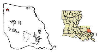
Lewisburg is an unincorporated community and census-designated place in St. Tammany Parish, Louisiana, United States. The community is located 7 miles south of Covington, Louisiana. It was first listed as a CDP in the 2020 census with a population of 420.

References

  1. "2020 U.S. Gazetteer Files". United States Census Bureau. Retrieved March 20, 2022.
  2. "Profile of General Population and Housing Characteristics: 2010 Demographic Profile Data (DP-1): Mandeville city, Louisiana". United States Census Bureau . Retrieved February 17, 2012.
  3. 1 2 "QuickFacts: Mandeville city, Louisiana". U.S. Census Bureau. Retrieved August 12, 2021.
  4. "City of Mandeville, Louisiana|History". City of Mandeville. Retrieved February 17, 2022.
  5. "Querbes, Andrew". Louisiana Historical Association, A Dictionary of Louisiana Biography. Archived from the original on December 1, 2010. Retrieved February 2, 2011.
  6. "Geographic Identifiers: 2010 Demographic Profile Data (G001): Mandeville city, Louisiana". United States Census Bureau . Retrieved February 17, 2012.
  7. "Census of Population and Housing". Census.gov. Retrieved June 4, 2015.
  8. "2019 Demographic and Housing Estimates". data.census.gov. Retrieved July 22, 2021.
  9. "U.S. Census website". United States Census Bureau . Retrieved January 31, 2008.
  10. "Geography Profile: Mandeville city, Louisiana". data.census.gov. Retrieved July 22, 2021.
  11. "Cultural Arts". Mandeville Louisiana. Retrieved April 28, 2024.
  12. "Jazz and Social Hall | Join Friends of the Dew Drop". My Website. Retrieved April 28, 2024.
  13. "Parks". City of Mandeville. Retrieved March 9, 2024.
  14. "Sunset Point & Fishing Pier | Mandeville, LA 70448". www.louisiananorthshore.com. Retrieved September 11, 2022.
  15. "2020 CENSUS - SCHOOL DISTRICT REFERENCE MAP: St. Tammany Parish, LA" (PDF). U.S. Census Bureau. Archived (PDF) from the original on July 31, 2022. Retrieved July 31, 2022. - Text list
  16. "Council Districts" (PDF). City of Mandeville. Retrieved March 9, 2024. - While the school district maps directly indicate the borders of Mandeville, this map may be a further resource one can use.
  17. "MAE%20K-3.jpg". St. Tammany Parish Public Schools . Retrieved March 9, 2024. - Name identified here
  18. "POE%20K-3.jpg". St. Tammany Parish Public Schools . Retrieved March 9, 2024. - Name identified here
  19. "WLE%20K-3.jpg". St. Tammany Parish Public Schools . Retrieved March 9, 2024. - Name identified here
  20. "MYE%20K-1.jpg". St. Tammany Parish Public Schools . Retrieved March 9, 2024. - Name identified here
  21. "MTE%202-3.jpg". St. Tammany Parish Public Schools . Retrieved March 9, 2024. - Name identified here
  22. "TMS%204-6.jpg". St. Tammany Parish Public Schools . Retrieved March 9, 2024. - Name identified here
  23. "LHM%204-6.jpg". St. Tammany Parish Public Schools . Retrieved March 9, 2024. - Name identified here
  24. "MAM%204-6.jpg". St. Tammany Parish Public Schools . Retrieved March 9, 2024. - Name identified here
  25. "MAJ%207-8.jpg". St. Tammany Parish Public Schools . Retrieved March 9, 2024. - Name identified here
  26. "FBJ%207-8.jpg". St. Tammany Parish Public Schools . Retrieved March 9, 2024. - Name identified here
  27. "LMJ%207-8.jpg". St. Tammany Parish Public Schools . Retrieved March 9, 2024. - Name identified here
  28. "MAH%209-12.jpg". St. Tammany Parish Public Schools . Retrieved March 9, 2024. - Name identified here
  29. "FOH%209-12.jpg". St. Tammany Parish Public Schools . Retrieved March 9, 2024. - Name identified here
  30. "LSH%209-12.jpg". St. Tammany Parish Public Schools . Retrieved March 9, 2024. - Name identified here
  31. "Home". Mary Queen of Peace School. Retrieved March 9, 2024. 1515 West Causeway Approach Mandeville, LA 70471
  32. "Home". Our Lady of the Lake School. Retrieved March 9, 2024. 316 Lafitte Street Mandeville Louisiana 70448
  33. "Home". Cedarwood School. Retrieved March 9, 2024. 607 Heavens Drive Mandeville LA 70471
  34. "Home". Lake Castle Private School. Retrieved March 9, 2024. 235 Highway 21 Madisonville, Louisiana
  35. "Mandeville Branch". St. Tammany Parish Library. Retrieved March 9, 2024.
  36. "Our Colleges". Louisiana's Technical and Community Colleges . Retrieved June 3, 2021.
  37. Mcauley, Anthony. "How ex-Saint Michael Mauti's painful journey led him into hemp business with a Doerr Furniture scion". NOLA.com. Retrieved February 27, 2023.
  38. Cindy Chang, "Mandeville mayor resigns under fire" in Times-Picayune, 2009 October 10, pp. A1, A11
  39. "Mayor Price's resignation" in Times-Picayune, 2009 October 10, Saint Tammany Edition, p. B4; Cindy Chang,
  40. "Council to pick interim mayor: Mandeville then will call special election" [ permanent dead link ] in Times-Picayune, 2009 October 12, Saint Tammany Edition, pp. B1, B2. Kia Hall Hayes
  41. "North Shore city selects leader" in Times-Picayune, 2009 October 18, Metro Edition, pp. A1, A8
  42. Suzanne Le Breton, "Lyons named interim mayor for Mandeville" in St. Tammany News, 2009 October 18 (Vol. 5 No. 21), pp. 1A, 6A.
  43. Schudel, Matt (June 27, 2017). "Margaux Fragoso, author of searing memoir of childhood sexual abuse, dies at 38". The Washington Post . Retrieved December 3, 2021. Survivors include her husband since 2010, Tom O'Connor, an English professor at Tulane University in New Orleans, and a daughter from her first marriage, Alicia McGowan, both of Mandeville, La.