Southeast Houston

Last updated
Aerial of the Texas Medical Center, an area in the Southeast Houston district. FlightHoustontoDallas086.jpg
Aerial of the Texas Medical Center, an area in the Southeast Houston district.

Southeast Houston is an area in Houston, Texas, United States. The Greater Southeast Management District (GSMD) manages a district using the name Southeast houston. Communities within the district include the Third Ward, Texas Medical Center, Riverside Terrace, University Oaks, and Washington Terrace. [1]

Contents

History

The Texas Legislature created the Greater Southeast Management District in 2001. [2] In 2005 District 146 was removed from the GSMD boundaries. Borris Miles, the area state representative, passed House Bill 1383, which would restore the original boundaries of the district. [3]

Economy

Grocers Supply's headquarters are within the district. [4]

Government and infrastructure

Ronald E. McNair South Central Police Station SouthCentralPoliceStationRonaldMcNairHoustonTX.JPG
Ronald E. McNair South Central Police Station

The Greater Southeast Management District is headquartered in Suite 503 at 5445 Almeda Road. [5]

The Houston Police Department's South Central Patrol Division, [6] in the Third Ward, [7] serves most of the district. Portions of the district are served by the Southeast Patrol Division. [8]

Houston Fire Department Station 25 Third Ward, in Fire District 46, serves Southeast Houston. [9] The station opened at the intersection of Blodgett and Velasco in 1928 and opened in its current location at Rosewood at Scott in 1979. [10] In addition Station 33 Medical Center, a part of Fire District 21, [9] is in Southeast Houston. The original Firehouse 33 was one of the last stations to be housed in an original volunteer fire station. The original Station 33 was the city hall/fire station of Braeswood. The City of Houston annexed the area in 1950. The current Fire Station 33 opened one block from the original station in August 2004. The city relinquished its ownership of the original fire station. [11]

Education

University of Houston Ezekiel W. Cullen Building (Alternate).JPG
University of Houston

Colleges and universities

Two state universities are located within the Greater Southeast Houston Management District.

The University of Houston is a nationally recognized Tier One research university, and is the flagship institution of the University of Houston System. [12] [13] [14] The third-largest university in Texas, the University of Houston has nearly 40,000 students on its 667-acre campus in southeast Houston. [15]

Within the Houston's historic Third Ward community is Texas Southern University. Founded in 1927, it is one of the largest historically black colleges and universities in the United States. In addition, TSU has specialized professional academic programs in pharmacy and law.

The Houston Community College System is the area community college system.

Yates High School Yates CIMG1903.JPG
Yates High School

Public schools

The community is zoned to Houston Independent School District (HISD) schools. The community is within Trustee District IV, represented by Paula M. Harris as of 2008. [16]

Middle schools serving sections of Southeast Houston district include Cullen and Ryan, both in the management district. [17] [18] Lamar and Yates high schools serve sections of Southeast Houston; Lamar is outside of the district while Yates is in the district. [19] [20]

Related Research Articles

<span class="mw-page-title-main">River Oaks, Houston</span> Subdivision in Houston, Texas, USA

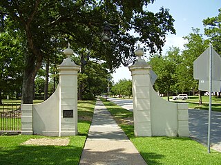
River Oaks is a residential community located in the center of Houston, Texas, United States. Located within the 610 Loop and between Downtown and Uptown, the community spans 1,100 acres (450 ha). Established in the 1920s by brothers Will Hogg and Michael Hogg, the community became a well-publicized national model for community planning. Real estate values in the community range from $1 million to over $20 million. River Oaks was also named the most expensive neighborhood in Houston in 2013. The community is home to River Oaks Country Club, which includes a golf course designed by architect Donald Ross and redesigned in 2015 by Tom Fazio.

<span class="mw-page-title-main">Chinatown, Houston</span> Neighborhood of Houston in Harris County, Texas, United States

Chinatown is a community in Southwest Houston, Texas, United States.

<span class="mw-page-title-main">Neartown Houston</span>

Montrose is an area located in west-central Houston, Texas, United States and is one of the city's major cultural areas. Montrose is a 7.5 square miles (19 km2) area roughly bounded by Interstate 69/U.S. Highway 59 to the south, Allen Parkway to the north, South Shepherd Drive to the west, and Taft to Fairview to Bagby to Highway 59 to Main to the east. Montrose neighborhoods include Cherryhurst, Courtlandt Place, Hyde Park, Montrose, Vermont Commons, North and East Montrose, Mandell Place and Winlow Place. Montrose is also less well known by the moniker Neartown, encompassing Superneighborhood #24.

<span class="mw-page-title-main">Midtown, Houston</span> Neighborhood of Houston in Harris County, Texas, USA

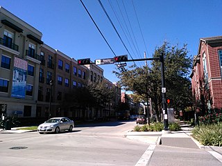
Midtown is a central neighborhood of Houston, located west-southwest of Downtown. Separated from Downtown by an elevated section of Interstate 45, Midtown is characterized by a continuation of Downtown's square grid street plan, anchored by Main Street and the METRORail Red Line. Midtown is bordered by Neartown (Montrose) to the west, the Museum District to the south, and Interstate 69 to the east. Midtown's 325 blocks cover 1.24 square miles (3.2 km2) and contained an estimated population of nearly 8,600 in 2015.

<span class="mw-page-title-main">Sharpstown, Houston</span> Community in Houston, Texas

Sharpstown is a master-planned community in the Southwest Management District, Southwest Houston, Texas. It was one of the first communities to be built as a master-planned, automobile centered community and the first in Houston. Frank Sharp (1906–1993), the developer of the subdivision, made provisions not only for homes but also for schools, shopping and recreation areas. While this model has been duplicated countless times in the past fifty years, at the time it was quite revolutionary, attracting national media attention. The development was dedicated on March 13, 1955.

<span class="mw-page-title-main">Westbury, Houston</span>

Westbury is a neighborhood in the Brays Oaks district of Southwest Houston, Texas, United States. It is located east of Bob White Road, north of U.S. Highway 90 Alternate, and west of South Post Oak Road, adjacent to the Fondren Southwest and Meyerland neighborhoods, just west of the southwest corner of the 610 Loop.

<span class="mw-page-title-main">Yates High School</span> Public high school in Houston, Texas, United States

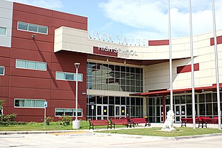
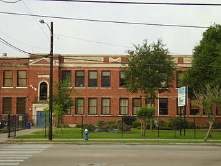
Jack Yates Senior High School is a public high school located at 3650 Alabama Street, very near Texas Southern University, in the historic Third Ward in Houston, Texas. Yates High School handles grades nine through twelve and is part of the Houston Independent School District (HISD).

<span class="mw-page-title-main">Upper Kirby</span> Neighborhood of Houston in Harris County, Texas, United States

Upper Kirby is a commercial district in Houston, Texas, United States. It is named after Kirby Drive, so indirectly takes its name from John Henry Kirby.

<span class="mw-page-title-main">Westchase, Houston</span> Place in Texas, United States

Westchase is a business district and neighborhood in western Houston, Texas, bounded by Westheimer Road on the north, Gessner Road on the east, Houston Center Boulevard on the west, and Westpark Tollway on the south. The area is bisected by Beltway 8. Westchase is adjacent to Greater Sharpstown, the International District, and the Royal Oaks Country Club subdivision. The area is immediately northeast of Alief.

<span class="mw-page-title-main">University Oaks, Houston</span>

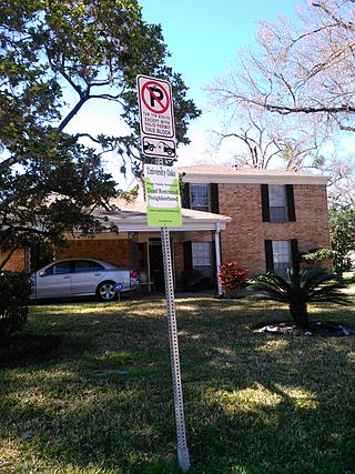
University Oaks is a subdivision in southeast Houston with approximately 240 homes located adjacent to the University of Houston. It is bounded by Wheeler Avenue to the north, South MacGregor Way to the south, Calhoun Road to the east, and Cullen Boulevard to the west.

<span class="mw-page-title-main">Third Ward, Houston</span> Neighborhood in Houston, Texas

Third Ward is an area of Houston, Texas, United States, that evolved from one of the six historic wards of the same name. It is located in the southeast Houston management district.

<span class="mw-page-title-main">Clinton Park, Houston</span>

Clinton Park is a neighborhood located in Houston, Texas. Clinton Park is located outside the 610 Loop in eastern Houston. Clinton Park is predominantly African-American. Carolyn Campbell of KHOU-TV described Clinton Park, close to the Port of Houston, as "small" and "isolated."

<span class="mw-page-title-main">Ryan Middle School (Houston)</span> School in Houston, Texas, United States

James D. Ryan Middle School was a secondary school located in Houston, Texas, United States. The Baylor College of Medicine Academy at Ryan, a magnet middle school, now occupies the campus.

<span class="mw-page-title-main">East End, Houston</span> District in Houston, Texas, United States

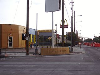
East End Houston, managed by the East End District (EED), is a district in eastern Houston, Texas, United States, located between the eastern edge of downtown to the Port of Houston and South to Hobby Airport. The District is home to Houston's early history and industry and is the site of Harrisburg, the seat of government for the Republic of Texas in 1836. East End Houston consists of many different ethnic groups, including Hispanic, Asian, White, and African American. Latinos make up more than half of the 100,512 residents, The area includes two of Houston's oldest Hispanic neighborhoods, Magnolia Park and Second Ward.

Morningside Place is a group of subdivisions located in Houston, Texas, United States.

Northgate Forest is a golf course community in unincorporated Harris County, Texas, United States, in Greater Houston. It is located directly off of Farm to Market Road 1960, 13 miles (21 km) west of George Bush Intercontinental Airport and 18 miles (29 km) north of Downtown Houston.

<span class="mw-page-title-main">Brays Oaks, Houston</span>

Brays Oaks, formerly known as Fondren Southwest, is an area in Southwest Houston, Texas, United States. The Brays Oaks Management District, also known as the Harris County Improvement District #5, governs the Brays Oaks area as well as other surrounding areas, such as Westbury. The City of Houston also defines the Brays Oaks Super Neighborhood, with separate boundaries.

<span class="mw-page-title-main">Southwest Management District</span> District in Houston, Texas

Southwest Management District, formerly Greater Sharpstown Management District, is a district in Houston, Texas, United States. The district is split into 6 neighborhoods: Sharpstown, Chinatown, Mahatma Gandhi District/Little India, Westwood, Harwin, and University.

The Airline Improvement District is a management district in unincorporated Harris County, Texas in Greater Houston and located entirely within the postal zip code of 77037.

<span class="mw-page-title-main">Montrose District, Houston</span>

The Montrose District was a management district located in Houston, Texas, United States. The land was governed by the Montrose Management District.

References

  1. "Area Maps Archived 2011-10-09 at the Wayback Machine ." (Map 1, Map 2) Greater Southeast Management District. Retrieved on May 22, 2009.
  2. "About Us." Greater Southeast Management District. Retrieved on April 16, 2009.
  3. "STATE REP. MILES' GREATER SOUTHEAST MANAGEMENT HB 1383 GETS UNANIMOUS PASSAGE." Texas House of Representatives . Retrieved on April 16, 2009.
  4. "Contact Us." Grocers Supply Company. Retrieved on December 1, 2011. "3131 E Holcombe Blvd Houston, TX. 77021-2199"
  5. "Contact Us." Greater Southeast Management District. Retrieved on April 16, 2009.
  6. "Crime Statistics for South Central Patrol Division." City of Houston. Retrieved on April 4, 2009.
  7. "VOLUNTEER INITIATIVES PROGRAM - Citizens Offering Police Support." City of Houston. Accessed October 28, 2008.
  8. "Crime Statistics for Southeast Patrol Division." City of Houston. Retrieved on April 28, 2010.
  9. 1 2 "Fire Stations." City of Houston. Retrieved December 4, 2008.
  10. "Fire Station 25." City of Houston. Retrieved on May 8, 2010.
  11. "Fire Station 33 Archived 2006-09-26 at the Wayback Machine ." City of Houston. Retrieved on May 8, 2010.
  12. Bonnin, Richard. "Carnegie Foundation Gives University of Houston its Highest Classification for Research Success, Elevating UH to Tier One Status". University of Houston. Retrieved 2011-02-08.
  13. "UH achieves Tier One status in research". Houston Business Journal. January 21, 2011. Retrieved 2011-07-06.
  14. "UH takes big step up to Tier One status". Houston Chronicle. Retrieved 2011-07-06.
  15. Khator, Renu (October 4, 2011). "State of the University: Fall 2011" (PDF). University of Houston. Archived from the original (PDF) on October 27, 2011. Retrieved October 5, 2011.
  16. "Trustee Districts Map Archived 2012-07-11 at the Wayback Machine ." Houston Independent School District . Retrieved on November 11, 2008.
  17. "Cullen Middle School Attendance Zone." Houston Independent School District . Retrieved on May 22, 2009.
  18. "Ryan Middle School Attendance Zone Archived 2007-06-30 at the Wayback Machine ." Houston Independent School District . Retrieved on May 22, 2009.
  19. "Lamar High School Attendance Zone Archived 2011-09-28 at the Wayback Machine ." Houston Independent School District . Retrieved on April 16, 2009.
  20. "Yates High School Attendance Zone Archived 2011-07-26 at the Wayback Machine ." Houston Independent School District . Retrieved on April 16, 2009.