| |||||
| Decades: | |||||
|---|---|---|---|---|---|
| See also: | |||||

The following lists events that happened during 1843 in Chile.
| |||||
| Decades: | |||||
|---|---|---|---|---|---|
| See also: | |||||
The following lists events that happened during 1843 in Chile.

The Magallanes Region, officially the Magallanes y la Antártica Chilena Region, is one of Chile's 16 first order administrative divisions. It is the southernmost, largest, and second least populated region of Chile. It comprises four provinces: Última Esperanza, Magallanes, Tierra del Fuego, and Antártica Chilena.

The Strait of Magellan, also called the Straits of Magellan, is a navigable sea route in southern Chile separating mainland South America to the north and Tierra del Fuego to the south. The strait is considered the most important natural passage between the Atlantic and Pacific oceans. The strait is approximately 570 km long and 2 km wide at its narrowest point. In 1520, the Spanish expedition of the Portuguese navigator Ferdinand Magellan, after whom the strait is named, became the first Europeans to discover it.

Moraleda Channel is a body of water separating the Chonos Archipelago from the mainland of Chile. It is located at 44.4147222°S 73.4205556°W, leading to Gulf of Corcovado. Southward from the mouth of the Aisén Fjord, Moraleda Channel divides into two arms. The east arm, called Canal Costa, is the main one. Farther south the name changes to Estero Elefantes, which terminates in the gulf of the same name. The channel runs along the Liquiñe-Ofqui Fault.

Chile has a large and intricate coastline of 4000 km with myriads of islands, islets, straits, bays, and fjords.

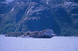
Fuerte Bulnes is a Chilean fort located by the Strait of Magellan, 62 km south of Punta Arenas. It was founded in 1843 on a rocky hill at Punta Santa Ana, and named after President Manuel Bulnes Prieto.

The Magellan expedition, sometimes termed the Magellan–Elcano expedition, was a 16th-century Spanish expedition planned and led by Portuguese explorer Ferdinand Magellan. One of the most important voyages in the Age of Discovery—and in the history of exploration—its purpose was to cross the Atlantic and Pacific Oceans to open a trade route with the Moluccas, or Spice Islands, in present-day Indonesia. The expedition departed Spain in 1519 and returned there in 1522 led by Spanish navigator Juan Sebastián Elcano, who crossed the Indian Ocean after Magellan's death in the Philippines. Totaling 60,440 km, or 37,560 mi, the nearly three-year voyage achieved the first circumnavigation of Earth in history. It also revealed the vast scale of the Pacific Ocean and proved that ships could sail around the world on a western sea route.

Manuel Rodríguez Island is an island in the Queen Adelaide Archipelago in Magallanes y la Antártica Chilena Region, Chile. It has an area of 466 km2 (180 sq mi).
Smyth Channel is a principal Patagonia channel. Its south arm is the southward continuation of the Sarmiento Channel and is located in Magallanes y Antártica Chilena Region. The Kawésqar people lived along its coast for thousands of years.
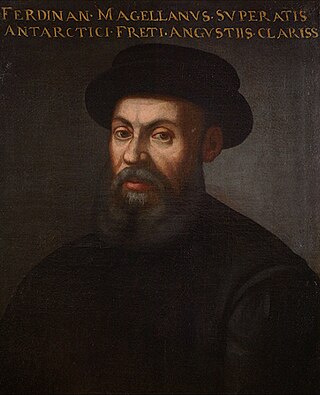
Ferdinand Magellan was a Portuguese explorer best known for having planned and led the 1519–22 Spanish expedition to the East Indies, which achieved the first circumnavigation of Earth in history. During the expedition, he also discovered the Strait of Magellan, allowing his fleet to pass from the Atlantic into the Pacific Ocean and perform the first European navigation to Asia via the Pacific. Magellan died in the Philippines during his voyage, and his crew completed the return trip to Spain in 1522.

The Boundary Treaty of 1881 between Argentina and Chile was signed on 23 July 1881 in Buenos Aires by Bernardo de Irigoyen, for Argentina, and Francisco de Borja Echeverría, for Chile, with the aim of establishing a precise border between the two countries based on the uti possidetis juris principle. Despite dividing largely unexplored lands, the treaty laid the groundwork for nearly all of Chile's and Argentina's 5600 km current border.
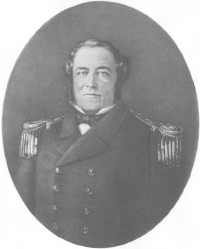
John Williams Wilson (1798–1857), also known as Juan Guillermos, was an English-Chilean sailor and politician. Born in Bristol, he entered the newly founded Chilean navy in 1824 and rose to the rank of commander. He was appointed governor of Talcahuano (1849–1855). He supervised construction of Fuerte Bulnes in 1843, which the government intended for a settlement at the Strait of Magellan. Puerto Williams, founded in 1953, was named for the naval commander.
The southern coast of Chile presents a large number of fjords and fjord-like channels from the latitudes of Cape Horn to Reloncaví Estuary. Some fjords and channels are important navigable channels providing access to ports like Punta Arenas, Puerto Chacabuco and Puerto Natales.

The flag of Magallanes y la Antártica Chilena Region is one of the regional symbols of the Chilean Magallanes y la Antártica Chilena Region. The flag was adopted in 1997 by the regional government, along with the Regional Coat of Arms.

Bárbara Channel is one of the three channels which connects Magellan Strait with the Pacific Ocean. It is located between the Santa Inés Island and the Clarence Island and ends at the Otway Bay, having the same entrance into the Pacific as Cockburn Channel, runs in a north direction along the west side of Clarence Island.
In Colonial times the Spanish Empire diverted significant resources to fortify the Chilean coast as a consequence of Dutch and English raids. During the 16th century the Spanish strategy was to complement the fortification work in its Caribbean ports with forts in the Strait of Magellan. As attempts at settling and fortifying the Strait of Magellan were abandoned the Spanish began to fortify the Captaincy General of Chile and other parts of the west coast of the Americas. The coastal fortifications and defense system was at its peak in the mid-18th century.
In the late 16th century, the Spanish Empire attempted to settle the Strait of Magellan with the aim of controlling the only known passage between the Atlantic and Pacific oceans at the time. The project was a direct response to Francis Drake's unexpected entry into the Pacific through the strait in 1578 and the subsequent havoc his men wreaked upon the Pacific coast of Spanish America. The colonization effort took the form of a naval expedition led by veteran explorer Pedro Sarmiento de Gamboa, which set sail from Cádiz in December 1581. The expedition established two short-lived settlements in the strait, Nombre de Jesús and Ciudad del Rey Don Felipe. However, the settlers proved poorly prepared for the cool and windy environment of the strait, and starvation and disease was soon rampant. A resupply expedition organized by Sarmiento in Rio de Janeiro in 1585 was unable to reach the strait due to unfavorable weather. Aid to the struggling colony was later hampered by Sarmiento falling prisoner to English corsairs in 1586 and the unresponsivity of King Philip II, likely due to the strain of Spain's resources caused by the wars with England and Dutch rebels. The last known survivor was rescued by a passing ship in 1590.

The Governorate of Terra Australis or Governorate of Pedro Sancho de la Hoz was a Spanish Governorate of the Crown of Castile created in 1539 which was granted to Pedro Sánchez de la Hoz and consisted in all the territories to the south of the Strait of Magellan until the South Pole, and, to the east and west, the borders were the ones specified in the treaties of Tordesillas and Zaragoza, respectively.
The Chilean takeover of the Strait of Magellan began in 1843 when an expedition founded Fuerte Bulnes. In 1848 the settlement of Punta Arenas was established further north in the strait and grew eventually to become the main settlement in the strait, a position it holds to this day. The Chilean settlement of the strait was crucial to establish its sovereignty claims in the area. Argentina complained diplomatically this act in 1847, as part of the East Patagonia, Tierra del Fuego and Strait of Magellan Dispute, and once the dispute was settled, formally recognised Chilean sovereignty of the strait in 1881. The Magallanes territory was made a regular Chilean province in 1928.