Contents
| |||||
| Decades: | |||||
|---|---|---|---|---|---|
| See also: | |||||
Events in the year 2016 in Chile.
| |||||
| Decades: | |||||
|---|---|---|---|---|---|
| See also: | |||||
Events in the year 2016 in Chile.

Concepción is a city and commune in south-central Chile, and the geographical and demographic core of the Greater Concepción metropolitan area, one of the three major conurbations in the country. It has a significant impact on domestic trade being part of the most heavily industrialized region in the country. It is the seat of the Concepción Province and the capital of the Bío Bío Region. It sits about 500 km south of the nation's capital, Santiago.

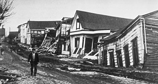
The 1960 Valdivia earthquake and tsunami or the Great Chilean earthquake on 22 May 1960 was the most powerful earthquake ever recorded. Most studies have placed it at 9.4–9.6 on the moment magnitude scale, while some studies have placed the magnitude lower than 9.4. It occurred in the afternoon, and lasted 10 minutes. The resulting tsunamis affected southern Chile, Hawaii, Japan, the Philippines, eastern New Zealand, southeast Australia, and the Aleutian Islands.

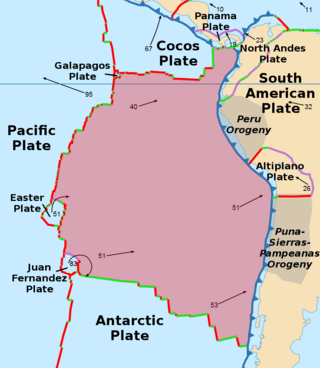
The Nazca Plate or Nasca Plate, named after the Nazca region of southern Peru, is an oceanic tectonic plate in the eastern Pacific Ocean basin off the west coast of South America. The ongoing subduction, along the Peru–Chile Trench, of the Nazca Plate under the South American Plate is largely responsible for the Andean orogeny. The Nazca Plate is bounded on the west by the Pacific Plate and to the south by the Antarctic Plate through the East Pacific Rise and the Chile Rise, respectively. The movement of the Nazca Plate over several hotspots has created some volcanic islands as well as east-west running seamount chains that subduct under South America. Nazca is a relatively young plate in terms of the age of its rocks and its existence as an independent plate, having been formed from the breakup of the Farallon Plate about 23 million years ago. The oldest rocks of the plate are about 50 million years old.

Valdivia is a city and commune in southern Chile, administered by the Municipality of Valdivia. The city is named after its founder, Pedro de Valdivia, and is located at the confluence of the Calle-Calle, Valdivia, and Cau-Cau Rivers, approximately 15 km (9 mi) east of the coastal towns of Corral and Niebla. Since October 2007, Valdivia has been the capital of Los Ríos Region and is also the capital of Valdivia Province. The national census of 2017 recorded the commune of Valdivia as having 166,080 inhabitants (Valdivianos), of whom 150,048 were living in the city. The main economic activities of Valdivia include tourism, wood pulp manufacturing, forestry, metallurgy, and beer production. The city is also the home of the Austral University of Chile, founded in 1954 and the Centro de Estudios Científicos.
The 1922 Vallenar earthquake occurred with a moment magnitude of 8.5–8.6 and a tsunami magnitude of 8.7 in the Atacama Region of Chile, near the border with Argentina on 11 November at 04:32 UTC. It triggered a destructive tsunami that caused significant damage to the coast of Chile and was observed as far away as Australia.

The 2010 Chile earthquake and tsunami occurred off the coast of central Chile on Saturday, 27 February at 03:34:12 local time, having a magnitude of 8.8 on the moment magnitude scale, with intense shaking lasting for about three minutes. It was felt strongly in six Chilean regions that together make up about 80 percent of the country's population. According to the United States Geological Survey (USGS) the cities experiencing the strongest shaking—VIII (Severe) on the Mercalli intensity scale (MM)—were Concepción, Arauco, and Coronel. According to Chile's Seismological Service, Concepción experienced the strongest shaking at MM IX (Violent). The earthquake was felt in the capital Santiago at MM VII or MM VIII. Tremors were felt in many Argentine cities, including Buenos Aires, Córdoba, Mendoza, and La Rioja. Tremors were felt as far north as the city of Ica in southern Peru. It is the largest earthquake to hit Chile since the 1960 Valdivia earthquake.
The 1985 Rapel Lake earthquake occurred on 8 April at 21:56:59 local time with a moment magnitude of 7.2 and a maximum perceived intensity of VI (Strong). The shock was centered 75 kilometres (47 mi) southwest of Santiago, Chile, with a focal depth of 37.8 km (23 mi).

The 2010 Pichilemu earthquakes, also known as the Libertador O'Higgins earthquakes, were a pair of intraplate earthquakes measuring 6.9 and 7.0 Mw that struck Chile's O'Higgins Region on 11 March 2010 about 16 minutes apart. The earthquakes were centred 15 kilometres (9.3 mi) northwest of the city of Pichilemu.
The following lists events that happened during 1949 in Chile.

The 2016 Chiloé earthquake with a magnitude of Mww 7.6 struck 225 kilometres (140 mi) south-west of Puerto Montt in southern Chile at 11:22 local time, 25 December. The earthquake triggered a tsunami warning on coasts located up to 1,000 kilometres (620 mi) from the quake's epicentre, generating massive evacuation across the Greater Chiloé Island, after advice from the Chilean government. Although there was damage in some parts of the island, the government reported no casualties.