Related Research Articles

The United States Numbered Highway System is an integrated network of roads and highways numbered within a nationwide grid in the contiguous United States. As the designation and numbering of these highways were coordinated among the states, they are sometimes called Federal Highways, but the roadways were built and have always been maintained by state or local governments since their initial designation in 1926.
U.S. Route 60 or U.S. Highway 60 (US 60) is a major east–west United States highway, traveling 2,655 mi (4,273 km) from southwestern Arizona to the Atlantic coast in Virginia. The highway's eastern terminus is in Virginia Beach, Virginia, where it is known as Pacific Avenue, in the city's Oceanfront resort district at the intersection of 5th Street and Winston-Salem Avenue. Its original western terminus was in Springfield, Missouri; it was then extended to Los Angeles, California; but in 1964 it was truncated to end southwest of Brenda, Arizona at an interchange with Interstate 10 (I-10) after the US 60 highway designation was removed from California. Some US 60 signs can be seen at this interchange about 5 mi (8.0 km) southwest of Brenda. I-10 replaced US 60 from Beaumont, California to Arizona, and California State Route 60 (SR 60) replaced US 60 from Los Angeles to Beaumont.

U.S. Route 160 (US 160) is a 1,465 mile (2,358 km) long east–west United States highway in the Midwestern and Western United States. The western terminus of the route is at US 89 five miles (8 km) west of Tuba City, Arizona. The eastern terminus is at US 67 and Missouri 158 southwest of Poplar Bluff, Missouri. Its route, if not its number, was made famous in song in 1975, as the road from Wolf Creek Pass to Pagosa Springs, Colorado in C.W. McCall's country music song Wolf Creek Pass.
Missouri Route 73 is a short state highway in southwest Missouri. It runs from an intersection with U.S. Route 65 in the northern part of Buffalo in Dallas County to U.S. Route 54 near Macks Creek in Camden County. The route is two lanes for its entire length.
Route 101 is a short highway in southern Missouri. The route starts at Arkansas Highway 101 at the Arkansas–Missouri state line, and travels northeastward. It travels through the city of Bakersfield, intersecting Route 142. The road then continues north to its northern terminus at U.S. Route 160 in Caulfield. The route was designated in 1941, after a supplementary route was renumbered.

Arkansas Highway 37 is a designation for two state highways in Arkansas. The main segment of 52.40 miles (84.33 km) runs from McCrory to Cord. A short segment of 0.61 miles (0.98 km) runs north in Benton County from U.S. Route 62 to the Missouri state line.
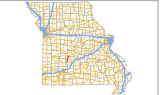
Route 16 is a 16.709-mile-long (26.891 km) highway in Lewis County, Missouri. The western terminus is at Route 6 east of Lewistown. The route travels eastward, through Monticello and a few rivers. Route 16 then intersects U.S. Route 61. The route ends at US 61 Business and Route B in Canton. The road was formerly part of Route 6, but it was rerouted in 1931. The old alignment was renumbered Route 96 that year. Ten years later, the route was renumbered to Route 16.
Route 75 is a short highway in Mississippi County in the U.S. state of Missouri. Its southern terminus is at Route 80, and it travels north through farmland to the town of Anniston. It then travels westward to its northern terminus at Route 105 north of East Prairie. The route was designated in 1968, after Route 77 was moved to a new alignment east of Anniston, and the remaining section was renumbered to Route 75.

State Highway 152 is a state highway running through west-central Oklahoma. It begins at the Texas state line, serving as a continuation of Texas State Highway 152, and continues east to end at Interstate 44 (I-44) in southwest Oklahoma City, a length of 149.2 miles (240.1 km). Along its route it serves three county seats: Sayre, Cordell, and Oklahoma City. Near its eastern end, it passes through the Oklahoma City suburb of Mustang. The easternmost 5.2 miles (8.4 km) of the route is a freeway linking Will Rogers World Airport to the Interstate system. SH-152 has no lettered spur routes.
In early July 1927, the Ohio Department of Highways implemented the system of United States Numbered Highways that had been approved by the states in late 1926. This resulted in the renumbering of many of the state highways to avoid overlaps with the new U.S. Routes and numbers used by both classes of route. In addition to the U.S. Routes, a new State Route 6 was formed, extending West Virginia Route 6 northwest from the Ohio River at Bridgeport to Norwalk.

Highway 115 is a state highway in Northeast Arkansas. The route begins at US Highway 167 and Highway 58 in Cave City and runs northeast to Missouri Route 21 near Doniphan, Missouri, including a 14 miles (23 km) concurrency with US 62/US 412 between Imboden and Pocahontas. The highway is maintained by the Arkansas Department of Transportation (ARDOT).

In 1926, Arkansas renumbered its highways into a more traditional format. The system to be replaced was established in 1924 as Arkansas' first comprehensive highway plan. Roads were designated as "primary federal aid roads", "secondary federal aid roads", or "connecting state roads". The Arkansas State Highway Commission implemented the system of United States Numbered Highways also around 1926, and thus Arkansas decided to number its highways instead of using the "letter-nn" format. This resulted in the first true numbering of state highways in Arkansas. Note that the numbers 61, 63, 64, 65, 67, 70, and 71 conflicted with U.S. Route designations, so there were no highways with these numbers, and no future highways could be numbered 165 or 167 as they conflicted with U.S. Route designations. The highest number was 115, reserving 116 and up for future use.
Iowa Highway 60 was a 223-mile-long (360 km) state highway that ran from the Missouri state line near Cincinnati, where it continued as Route 5, to U.S. Highway 18 (US 18) near Wesley. The highway passed through Centerville, Knoxville, Des Moines, and Webster City during is trek. It was an original state highway that was in service for 48 years. The highway originally only extended from Des Moines to Goldfield, but was extended in 1931. At that time, it absorbed Iowa Highway 6. On January 1, 1969, the highway had ceased to exist. The Iowa State Highway Commission renumbered several state highways in order to match up route numbers with adjacent state highways. It was replaced by Iowa 5 south of Des Moines and Iowa 17 north of Granger.
In late 1925, the Iowa State Highway Commission, now known as the Iowa Department of Transportation, announced plans to renumber several state highways. The changes to the highway system were a result of the creation of the United States Numbered Highway System. The new U.S. Highways replaced several of the state's primary roads and other routes were renumbered in order to eliminate driver confusion between the two systems. As the new highways were being signed, Iowa's state highways were given a new circular route marker. Previously, the primary road number was stenciled in black onto a telegraph pole over a band of yellow paint.
Highway 130 is an east–west state highway in Arkansas County, Arkansas. Mostly a low-volume, two-lane road, Highway 130 connects the two county seats of Arkansas County, Stuttgart and DeWitt. The highway began as State Road 30, one of the original state highways in 1926 between North Little Rock and DeWitt. It was renumbered to 130 to prevent confusion with Interstate 30 in 1958, and the segment between North Little Rock and Stuttgart was replaced by an extension of US 165 in 1981, producing the current alignment. Highway 130 has one spur route in Almyra, and a former alternate route in DeWitt that was designated but never built. The routes are maintained by the Arkansas Department of Transportation (ARDOT).
References
- ↑ "1922 Missouri Highway Commission Map".
- ↑ "Map of Missouri showing state road system route numbers, road conditions & points of interest issued by Missouri State Highway Commission" (PDF). 1926. Archived from the original (PDF) on 2017-02-16. Retrieved 2018-02-08.
- ↑ "Map of Missouri showing state road system route numbers, road conditions & points of interest issued by Missouri State Highway Commission" (PDF). January 1, 1927. Archived from the original (PDF) on September 16, 2012. Retrieved February 8, 2018.