
Interstate 81 (I-81) is a north–south Interstate Highway in the eastern part of the United States. Its southern terminus is at I-40 in Dandridge, Tennessee; its northern terminus is on Wellesley Island at the Canadian border, where the Thousand Islands Bridge connects it to Highway 401, the main Ontario freeway connecting Detroit via Toronto to Montreal. The major metropolitan areas that I-81 connects to include Harrisburg and the Wyoming Valley in Pennsylvania and Syracuse in New York.

Interstate 77 (I-77) is a north–south Interstate Highway in the eastern United States. It traverses diverse terrain, from the mountainous state of West Virginia to the rolling farmlands of North Carolina and Ohio. It largely supplants the old U.S. Route 21 between Cleveland, Ohio, and Columbia, South Carolina, as an important north–south corridor through the middle Appalachians. The southern terminus of Interstate 77 is in Columbia at the junction with Interstate 26. The northern terminus is in Cleveland at the junction with Interstate 90. Other major cities that I-77 connects to include Charlotte; Charleston, West Virginia and Akron, Ohio. The East River Mountain Tunnel, connecting Virginia and West Virginia, is one of only two instances in the United States where a mountain road tunnel crosses a state line. The other is the Cumberland Gap Tunnel, connecting Tennessee and Kentucky. I-77 is a route to the southern United States for those traveling from the Great Lakes region.

U.S. Route 29 is a north–south United States highway that runs for 1,036 miles (1,667 km) from Pensacola, Florida to the western suburbs of Baltimore, Maryland. This highway takes on an overall northeast path, from its southern terminus at US 90 and US 98 in Pensacola, Florida to its northern terminus at Maryland Route 99 in Ellicott City, Maryland.
U.S. Route 58 is an east–west U.S. Highway that runs for 508 miles (818 km) from U.S. Route 25E just northwest of Harrogate, Tennessee, to U.S. Route 60 in Virginia Beach, Virginia. Until 1996, when the Cumberland Gap Tunnel opened, US 58 ran only inside the commonwealth of Virginia. It was then extended southwest along a short piece of former US 25E, which no longer enters Virginia, to end at the new alignment in Tennessee.

U.S. Route 460 (US 460) is a spur of U.S. Route 60. It currently runs for 655 miles (1,054 km) from Norfolk, Virginia, at its parent route U.S. Route 60 at Ocean View to Frankfort, Kentucky, at its parent route once again. It passes through the states of Virginia, West Virginia, and to Frankfort, Kentucky, the state capital. It goes through the cities of Norfolk, Portsmouth, Suffolk, Petersburg, Farmville, Lynchburg, Roanoke, Blacksburg, Tazewell, and Grundy, in Virginia; Princeton and Bluefield in West Virginia; and Pikeville, and Frankfort, Kentucky.
Interstate 195 (I-195) is an Interstate Highway in the U.S. state of Virginia. Known as the Beltline Expressway, the highway runs 3.50 miles (5.63 km) from Virginia State Route 195, a toll road that continues south into Downtown Richmond, north to I-64 and I-95 on the northern edge of Richmond. I-195 passes through the West End of Richmond and connects I-64 and I-95 with U.S. Route 33 and US 250, which follow Broad Street, and with SR 76, a toll road that links Richmond with the Southside of the metropolitan area.

The Appalachian Development Highway System (ADHS) is part of the Appalachian Regional Commission in the United States. It consists of a series of highway corridors in the Appalachia region of the eastern United States. The routes are designed as local and regional routes for improving economic development in the historically isolated region. It was established as part of the Appalachian Regional Development Act of 1965, and has been repeatedly supplemented by various federal and state legislative and regulatory actions. The system consists of a mixture of state, U.S., and Interstate routes. The routes are formally designated as "corridors" and assigned a letter. Signage of these corridors varies from place to place, but where signed are often done so with a distinctive blue-colored sign.
Interstate 95 (I-95) runs 179 miles (288 km) within the Commonwealth of Virginia between its borders with Maryland and North Carolina. I-95 is concurrent with I-64 for 3 miles (4.8 km) in Richmond, and meets the northern terminus of I-85 in Petersburg. Although I-95 was originally planned as a highway through Washington, D.C., it was rerouted along the eastern portion of the Capital Beltway. From Petersburg to Richmond, I-95 was most of the Richmond-Petersburg Turnpike
In 1963 and 1964, the California Division of Highways implemented a major renumbering of its state highways. The majority of sign routes—those marked for the public—kept their numbers; the main changes were to the legislative routes, which had their numbers changed to match the sign routes. Many formerly unsigned routes received sign numbers corresponding to their new legislative numbers. A smaller change was the removal and truncating of many U.S. Routes in favor of the Interstate Highways, and the renumbering of State Routes that conflicted with Interstate numbers. Some U.S. Routes that were officially removed continued to be signed until the replacement Interstates were completed.

State Route 169 is a primary state highway in the U.S. state of Virginia. The state highway runs 7.41 miles (11.93 km) from Interstate 64 (I-64) and U.S. Route 60 to US 258 within the independent city of Hampton. SR 169 is a C-shaped route that connects the Hampton neighborhoods of Phoebus, Buckroe Beach, and Fox Hill.
U.S. Route 1 (US 1) is a major north–south U.S. Highway that serves the East Coast of the United States. In the U.S. state of Virginia, US 1 runs north–south through South Hill, Petersburg, Richmond, Fredericksburg, and Alexandria on its way from North Carolina to the 14th Street Bridge into the District of Columbia. It is completely paralleled by Interstate Highways in Virginia – Interstate 85 (I-85) south of Petersburg, Interstate 95 north to Alexandria, and Interstate 395 into the District – and now serves mainly local traffic. At its north end, on the approach to the 14th Street Bridge, US 1 is concurrent with I-395; the rest of US 1 is on surface roads.
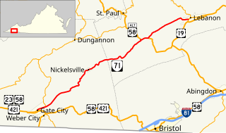
State Route 71 is a primary state highway in the southwest part of the U.S. state of Virginia. It runs from Gate City northeast to Lebanon, mostly through river valleys. Despite running more east–west than north–south, it is signed north–south; it parallels the similarly-oriented U.S. Route 11 and Interstate 81.

State Route 65, formerly State Route 66, is a primary state highway in the U.S. state of Virginia. The state highway runs 34.06 miles (54.81 km) from U.S. Route 23, US 58, and US 421 in Clinchport north to US 58 Alternate in Castlewood.

State Route 69 is a primary state highway in the U.S. state of Virginia. Known as Lead Mine Road, the state highway runs 3.59 miles (5.78 km) from SR 636 in Austinville east to U.S. Route 52 in Poplar Camp. SR 69 is the last remnant of a much longer route. At its peak from 1940 to 1945, this route ran from State Route 91 at Lodi east via St. Clair Bottom, Sugar Grove, Cedar Springs, Speedwell, Porters Crossroads, and Austinville to today's SR 69. However, it was never fully continuous; portions from Sugar Grove to Cedar Springs and west of Porters Crossroads to east of Austinville were secondary routes. The full length of this route as it existed and was planned is now part of SR 762, part of SR 660, all of SR 650, part of SR 16, all of SR 614, part of SR 749, part of US 21, part of SR 690, a small piece of SR 642, part of SR 619, part of SR 636, and SR 69.
In late 1940, the Commonwealth of Virginia renumbered some of its state highways in order to provide continuous numbers across state lines. At the same time, Maryland, North Carolina, and West Virginia took part by renumbering some of their highways to match Virginia's, and Tennessee planned to renumber one of its highways but never did.

State Route 271 is a primary state highway in the U.S. state of Virginia. Known as Pouncey Tract Road, the state highway runs 7.34 miles (11.81 km) from U.S. Route 250 in Short Pump north to SR 620 and SR 622 in Rockville. A small section of it was first added to the state highway system as State Route 431 in 1930. By 1940, it had gained its current routing and designation.
Interstate 81 (I-81) is an 855-mile-long (1,376 km) Interstate Highway stretching from Dandridge, Tennessee, northward to the Thousand Islands Bridge at the Canadian border near Fishers Landing, New York. In Tennessee, I-81 travels 75.66 miles (121.76 km) from its southern terminus at I-40 in Dandridge to the Virginia state line in Bristol. In addition, the route serves the Tri-Cities region of northeast Tennessee, but bypasses most cities that it serves, instead providing access via interchanges with state and federal routes. In Tennessee, I-81 remains in the Ridge and Valley topographic region of the Appalachian Mountains, and runs in a more northeast-southwest direction.
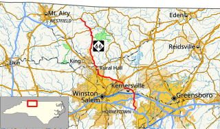
North Carolina Highway 66 (NC 66) is a 47.4-mile (76.3 km) North Carolina state highway that travels from Horneytown to Johnstown, connecting the towns and communities of eastern Forsyth and Stokes counties.