2011–12 Australian bushfire season

Last updated

2011-12 Australian bushfire season
2011-12 Australian Bushfire season MODIS overview.png
NASA MODIS burned area detections from June 2011 to May 2012
Date(s)Winter (June) 2011 – Autumn (May) 2012
Location Australia
Statistics
Burned area>14,076 square kilometres (5,435 sq mi)
Impacts
Deaths0
Non-fatal injuries4 (at least)
Structures destroyed39 lost, at least 20 damaged
Fires in Western Australia 2012 - NASA Earth Observatory Fires in Western Australia - NASA Earth Observatory.jpg
Fires in Western Australia 2012 - NASA Earth Observatory
Controlled burn off on North Stradbroke Island Controlled burn off on North Stradbroke Island.jpg
Controlled burn off on North Stradbroke Island

Bushfires were mostly active between September 2011 to March 2012 and caused most damage in the state of Western Australia, particularly in the South West. The state had been prepared and had expected an increased risk of bushfire following heavy spring rains as a result of a La Nina weather pattern. [1]

Contents

September

Northern Territory

Large fires swept through the Barkly Tableland and Victoria River districts, destroying large tracts of grazing land. Fire fronts estimated at 50 kilometres (31 mi) were reported; the Barkly fire resulted in 7,000 square kilometres (2,700 sq mi) of country being burnt with another 2,000 square kilometres (770 sq mi) being lost in the Victoria River district. [2]

Western Australia

During the Kimberley Ultramarathon on 2 September, a bushfire raced through the course, engulfing a group of four participants at El Questro Station. Two men escaped the flames, suffering severe burns but the two females were trapped, each suffering critical injuries. Thirty grass fires were burning in Kimberley at the same time. [3] Several other fires were burning through the Kimberley, resulting in the loss of 60,000 hectares (150,000 acres) of grassland. [4] It has since been discovered that Kimberley locals were lighting fires before and on the day of the race. [5]

October

NSW

A bushfire at Katoomba and the Blue Mountains on 24 October caused some houses and a school to be evacuated, over 100 fire-fighters and three aircraft responding to contain the blaze. Some minor property damage occurred but no homes were lost in the blaze. [6]

November

WA

A fire broke out near Margaret River in the South West region on 23 November. Temperatures in excess of 30 °C (86 °F) and strong winds fanned what began as a controlled burn in the Leeuwin-Naturaliste National Park. [7] The fire soon swept over the town causing hundreds of people from Prevelly, Gnarabup and the town outskirts to be evacuated to the beach. [8] By the following day dozens of homes had been lost to the fire, including historic Wallcliffe House. The premier, Colin Barnett, declared Margaret River a Natural Disaster Zone and promised a full inquiry as to how the fire started. [9] The fire was controlled by 26 November after burning through 3,400 hectares (8,400 acres) of land and leaving a total of 39 homes destroyed and another 14 damaged, but there were no deaths. [10]

Other bushfires were recorded at the same time about 30 kilometres (19 mi) south west of Nannup, another near Three Springs, a third near Peron and a fourth north of Denmark.

In the Pilbara region a large bushfire burnt through an area of 650 square kilometres (251 sq mi) of bushland in the Nimingarra area close to the Yarrie minesite. [11]

December

WA

The Denmark fire was contained but warnings remained by 1 December, a total of 5,600 hectares (14,000 acres) were lost. The Nannup fire continued to burn and was not contained until 3 December, by 2 December it had claimed some 30,000 hectares (74,000 acres), it had started as a prescribed burn but had raged out of control. [12] Once finally extinguished it had burnt out about 55,100 hectares (136,000 acres) of land. [13]

A large fire in the Pilbara region had burned out over 1,500 square kilometres (579 sq mi) of bushland and rangeland by 26 December. A large portion of Giralia Station was burnt out with the firecoming close to the homestead before being extinguished. Yanrey and Koordarrie Stations were also threatened by the blaze. [14]

January

QLD

Moreton Island suffered a grass fire that burnt out 160 hectares (400 acres) of the island vegetation and came within 500 metres (1,600 ft) of the small community of Cowan which was protected by backburning. The fire started on 4 January and was expected to burn for weeks.[ needs update ] [15]

SA

A fire that started 4 January and burnt for three days burnt 8,000 hectares (20,000 acres) of pastoral lands, damaging stock in an area approximately 40 kilometres (25 mi) south east of Port Augusta. [16]

VIC

A fire broke out in the Grampians on 4 January and was thought to have been started by lightning. 150 fire-fighters battled the blaze along with water bombing aircraft. Over 230 hectares (570 acres) of bushland was burnt in the blaze. [17]

WA

A fire that started in late December in the Yalgoo Shire was mostly contained by 5 January after burning out an area of 18,500 hectares (46,000 acres) of bushland. More fires were also ignited in the Kearney State forest, near Nannup, resulting from lightning strikes. [18]

A large fire in the Gascoyne burnt out approximately 30 kilometres (19 mi) of grazing and bushland. It spread over a distance of 45 kilometres (28 mi), leading to the temporary closure of the North West Coastal Highway and other roads around Kennedy Range National Park. The fire burnt for a week after a smaller fire escaped containment lines on 8 January, [19] burning out over 3,300 square kilometres (1,300 sq mi) by 15 January and then continuing to burn until 30 January.

Other fires that broke out late in January in Wooroloo and Chittering were both under control by 30 January. [20]

February

WA

The town of Northcliffe was menaced by a bushfire that came within 8 kilometres (5.0 mi) of the townsite on 22 February. Smoke haze from the fire effected the south west coast of the state. [21] The fire had been ignited by lightning on 8 February and had burnt out over 16,000 hectares (40,000 acres) 14 February and was expected to burn over 30,600 hectares (76,000 acres) before being contained. [22]

March

WA

A fire broke out north of Nannup and was brought under control by 14 March. 113 personnel, 13 trucks and 4 earthmovers were used in containing the blaze. [23] The suburb of Koondoola was struck by a fire that threatened homes on 28 March. The fire that started under suspicious circumstances burnt out 45ha of bushland and required 55 fire-fighters and waterbombers to bring it under control. [24]

Related Research Articles

<span class="mw-page-title-main">2006–07 Australian bushfire season</span> Australian bushfire

One of the most extensive bushfire seasons in Australia's history. Victoria experienced the longest continuously burning bushfire complex in Australia's history, with fires in the Victorian Alps and Gippsland burning over 1 million hectares of land over the course of 69 days. See Bushfires in Australia for an explanation of regional seasons.

<span class="mw-page-title-main">Two Peoples Bay Nature Reserve</span> Nature reserve in Western Australia

Two Peoples Bay Nature Reserve is a protected area managed by the Department of Parks and Wildlife 35 kilometres (22 mi) east of Albany, Western Australia. The area is accessible by 2WD vehicles. The bay itself, including two small secluded beaches, faces due east and is protected from the Southern Ocean by a headland formed by the granite massif of Mount Gardner. The nature reserve was established in 1967 to protect the threatened noisy scrub-bird and its habitat. It is known for being the site of the discovery and naming of Gilbert's potoroo, but in 2015 a huge fire destroyed 90% of the tiny marsupial's habitat, as well as killing three-quarters of the remaining small population.

<span class="mw-page-title-main">2008–09 Australian bushfire season</span>

The Australian bushfire season ran from late December 2008 to April/May 2009. Above average rainfalls in December, particularly in Victoria, delayed the start of the season, but by January 2009, conditions throughout South eastern Australia worsened with the onset of one of the region's worst heat waves. On 7 February, extreme bushfire conditions precipitated major bushfires throughout Victoria, involving several large fire complexes, which continued to burn across the state for around one month. 173 people lost their lives in these fires and 414 were injured. 3,500+ buildings were destroyed, including 2,029 houses, and 7,562 people displaced.

<span class="mw-page-title-main">Black Saturday bushfires</span> Deadly bushfires in Victoria State, Australia, in 2009

The Black Saturday bushfires were a series of bushfires that either ignited or were already burning across the Australian state of Victoria on and around Saturday, 7 February 2009, and were one of Australia's all-time worst bushfire disasters. The fires occurred during extreme bushfire weather conditions and resulted in Australia's highest-ever loss of human life from a bushfire, with 173 fatalities. Many people were left homeless as a result.

<span class="mw-page-title-main">2009–10 Australian bushfire season</span>

A bushfire season occurred predominantly from June 2009 to May 2010. Increased attention has been given to this season as authorities and government attempt to preempt any future loss of life after the Black Saturday bushfires during the previous season, 2008–09. Long range weather observations predict very hot, dry and windy weather conditions during the summer months, leading to a high risk of bushfire occurrence.

<span class="mw-page-title-main">2010–11 Australian bushfire season</span>

During the summer of 2010–11, a relative lack of bushfires occurred along Eastern Australia due to a very strong La Niña effect, which instead contributed to severe flooding, in particular the 2010–11 Queensland floods and the 2011 Victorian floods. As a result of these weather patterns, most major fire events took place in Western Australia and South Australia. Some later significant fire activity occurred in Gippsland in eastern Victoria, an area which largely missed the rainfall that lead to the flooding in other parts of the state.

Champion Bay Senior High School is a comprehensive public co-educational middle day school, located in Karloo, a suburb of Geraldton, a regional centre 424 kilometres (263 mi) north west of Perth, Western Australia.

<span class="mw-page-title-main">2012–13 Australian bushfire season</span>

The summer of 2012–13 had above average fire potential for most of the southern half of the continent from the east coast to the west. This is despite having extensive fire in parts of the country over the last 12 months. The reason for this prediction is the abundant grass growth spurred by two La Niña events over the last two years.

<span class="mw-page-title-main">2013 New South Wales bushfires</span>

The 2013 New South Wales bushfires were a series of bushfires in Australia across the state of New South Wales primarily starting, or becoming notable, on 13 October 2013; followed by the worst of the fires beginning in the Greater Blue Mountains Area on 16 and 17 October 2013.

<span class="mw-page-title-main">2014–15 Australian bushfire season</span>

The bushfire season in the summer of 2014–15, was expected to have the potential for many fires in eastern Australia after lower than expected rainfall was received in many areas. Authorities released warnings in the early spring that the season could be particularly bad.

<span class="mw-page-title-main">2015–16 Australian bushfire season</span>

The most destructive bushfire season in terms of property loss since the 2008–09 Australian bushfire season, occurred in the summer of 2015–16, with the loss of 408 houses and at least 500 non-residential buildings as a result of wild fires between 1 June 2015 and 31 May 2016. The season also suffered the most human fatalities since the 2008–09 Australian bushfire season; 6 died in Western Australia, 2 in South Australia and 1 in New South Wales. 8 deaths were as a direct result of fire, and a volunteer firefighter died due to unrelated health complications while on duty.

<span class="mw-page-title-main">2015 Esperance bushfires</span>

The 2015 Esperance bushfires were a series of catastrophic bushfires that burned from 15 to 26 November and affected the Goldfields-Esperance region in the Australian state of Western Australia. During the fires, the Shire of Esperance experienced two significant fires and a complex of fires; 128,000 hectares were burnt by the Cascades fire, 18,000 hectares were burnt by the Merivale fire, and 164,000 hectares were burnt by the Cape Arid complex of fires. On 17 November, during the major run of the Cascades fire, four civilian fatalities occurred in vehicles traveling on Griggs Road in Scaddan. As of 2020, the Cascades fire was equally the worst bushfire in Western Australia in terms of human fatalities along with the Willow Springs/Nannup fire of January 1958.

<span class="mw-page-title-main">2017–18 Australian bushfire season</span>

The bushfire season of the summer of 2017–18, was expected to have above normal bushfire risks with an elevated fire risk for the most of eastern and south Australian coastal areas. Australia had experienced its warmest winter on record and the ninth driest winter on record leaving dry fuel loads across much of southern Australia. Expected warmer weather over the summer period would also increase the risk. Bushfires were also expected to occur earlier, before the end of winter, as a result of the warm and dry winter. Both Queensland and north-eastern New South Wales experienced the wettest October since 1975 leading to a downgrade in bushfire risk.

<span class="mw-page-title-main">2018–19 Australian bushfire season</span> Fire season in Australia

The bushfires were predicted to be "fairly bleak" in parts of Australia, particularly in the east, by the Bushfire and Natural Hazards Cooperative Research Centre (CRC) chief executive, Richard Thornton, in September 2018. Large bushfires had already burned through southern New South Wales during winter. The outlook for spring was of a higher likelihood of fires with a twice the normal chance of an El Nino for summer. Many parts of eastern Australia including Queensland, New South Wales and Gippsland, in Victoria, were already in drought. Above normal fire was also predicted for large parts of Southern Australia and Eastern Australia by the Bushfire and Natural Hazards CRC. The forecast noted that Queensland had recorded the ninth driest and fourth hottest period on record from April to November. New South Wales recorded the fourth hottest period and eighth driest on record, while Victoria experiences the 13th driest and seventh hottest period on record. Authorities in New South Wales brought forward the start of the bushfire season for much of the state from October 2018 to the beginning of August 2018.

<span class="mw-page-title-main">1974–75 Australian bushfire season</span>

The 1974–75 Australian bushfire season is a series of bushfires, also known around the world as wildfires, that burned across Australia. Fires that summer burned up an estimated 117 million hectares. Approximately 15% of Australia's land mass suffered "extensive fire damage" including parts of New South Wales, the Northern Territory, Queensland, South Australia and Western Australia.

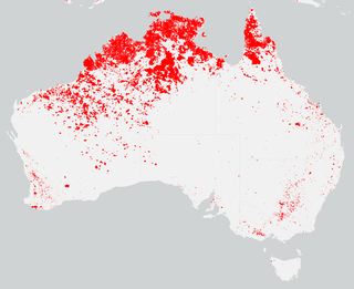
The 2020–21 Australian bushfire season was the season of summer bushfires in Australia. Following the devastating 2019–20 bushfires in Australia, authorities were urged to prepare early for the 2020–21 Australian bushfire season. The bushfire outlook for July to September 2020 was predicting a normal fire potential in Queensland with a good grass growth in many areas giving an increased risk of grass fires, an above normal season in the Kimberley region of Western Australia as a result of good rains from tropical cyclones, a normal but earlier season in the Northern Territory, an above normal season on the south coast of New South Wales and normal seasons elsewhere.

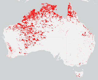
The 2021–22 Australian bushfire season was the season of summer bushfires in Australia. The outlook for the season was below average in parts of Eastern Australia thanks to a La Niña, with elevated fire danger in Western Australia. Higher than normal winter rainfall has resulted in above average to average stream flows and soil moisture levels through much of eastern Australia. The outlook to the end of spring was also for above average falls over much of the country apart for Western Australia. The Australian Capital Territory, Victoria and southern New South Wales are expected to have a below normal fire potential as a result of vegetation still recovering from the 2020–21 Australian bushfire season. Areas of south eastern Queensland, northern New South Wales and northern Western Australia expect an above normal fire potential caused by crop and grass growth in these areas.

The 2021 Beechina bushfire was a bushfire that began on 26 December 2021 in Beechina, 46 kilometres east-north-east of the Perth central business district, in the Shire of Mundaring, Western Australia. The bushfire began less than five kilometres from the 2021 Wooroloo bushfire, and coincided with a COVID-19 outbreak and associated public health measures in the Perth metropolitan region. One house was destroyed as a result of the fire, along with six outbuildings and a number of vehicles.

The 2023–24 Australian bushfire season is the current season of bushfires in Australia. The spring and summer outlook for the season prediction was for increased risk of fire for regions in Queensland, New South Wales, Victoria, South Australia and the Northern Territory.

References

  1. "2011 South West bushfire season outlook". Australian Broadcasting Corporation. 15 November 2011. Retrieved 9 December 2012.
  2. "Bushfires torch large areas of northern Australia". Beef Central. 14 September 2011. Archived from the original on 21 November 2011. Retrieved 9 December 2012.
  3. "There was no control over bushfire that scorched runners: police". Beef Central. 6 September 2011. Archived from the original on 28 February 2013. Retrieved 9 December 2012.
  4. "Bushfires burn out Kimberley grazing land". Accidentally Outback. 22 September 2011. Archived from the original on 19 April 2013. Retrieved 12 December 2012.
  5. "Report on a corporation aversely referred to the Legislative Assembly - Racingthe planet" (PDF). Parliament of Western Australia. 1 August 2014. Retrieved 30 November 2014.
  6. "Fire forces Katoomba residents to evacuate". Australian Broadcasting Corporation. 24 October 2011. Retrieved 9 December 2012.
  7. "The Margaret River Bushfires". Australian Broadcasting Corporation. 14 December 2011. Archived from the original on 25 November 2012. Retrieved 9 December 2012.
  8. "Residents flee to beach as bushfire destroys homes". Sydney Morning Herald . Fairfax Media. 24 November 2011. Retrieved 9 December 2012.
  9. "SW fire fanned by strong winds, heat". The West Australian . 24 November 2011. Retrieved 9 December 2012.
  10. "Toll from Margaret River fire continues to rise". Australian Broadcasting Corporation. 26 November 2011. Retrieved 9 December 2012.
  11. Emma Wynne (28 November 2011). "Bushfire All Clear for Nimingarra". Australian Broadcasting Corporation . Retrieved 4 May 2014.
  12. "Nannup burn still a threat". The West Australian. 2 December 2011. Retrieved 9 December 2012.
  13. "The Margaret River Bushfires". Australian Broadcasting Corporation. 14 December 2011. Archived from the original on 25 November 2012. Retrieved 9 December 2012.
  14. "Bushfire threatens properties in remote WA". Australian Broadcasting Corporation. 26 December 2014. Retrieved 4 May 2014.
  15. "Moreton Island fire 'could burn for weeks'". The Courier Mail. 5 January 2012. Retrieved 9 December 2012.
  16. "Woolundunga bushfire threat reduced". Australian Broadcasting Corporation. 7 January 2012. Retrieved 9 December 2012.
  17. "Fire hits three Australian states: Queensland, Victoria and South Australia". The Daily Telegraph. 6 January 2012. Retrieved 9 December 2012.
  18. "Lightning starts bushfires near Nannup". The West Australian . Yahoo7. 5 January 2012. Retrieved 23 January 2012.
  19. "Gascoyne Bushfire - January 2012". Australian Broadcasting Corporation. 15 January 2012. Archived from the original on 24 July 2013. Retrieved 9 December 2012.
  20. "Chittering threat eases as fire contained". Sunday Times. 30 January 2012. Retrieved 9 December 2012.
  21. "Northcliffe Fire - February 2012". Australian Broadcasting Corporation. 22 February 2012. Retrieved 10 December 2012.
  22. "Northcliffe bushfire smoke covers South-West". Sunday Times. 14 February 2012. Retrieved 10 December 2012.
  23. "Nannup bushfire under control". Australian Broadcasting Corporation. 14 March 2012. Archived from the original on 1 December 2012. Retrieved 10 December 2012.
  24. "Bushfire threatened properties in Koondoola". Australian Broadcasting Corporation. 28 March 2012. Retrieved 10 December 2012.