400 East Randolph

Last updated
Outer Drive East
Outer drive east chicago.JPG
400 East Randolph
General information
TypeResidential condos
Location400 E Randolph St.
Chicago, Illinois
Coordinates 41°53′5.29″N87°36′59.4″W / 41.8848028°N 87.616500°W / 41.8848028; -87.616500 Coordinates: 41°53′5.29″N87°36′59.4″W / 41.8848028°N 87.616500°W / 41.8848028; -87.616500
Completed1963
ManagementThe Habitat Company
Height
Roof115 m (377 ft)
Technical details
Floor count40
Design and construction
Architect(s)Reinheimer & Associates

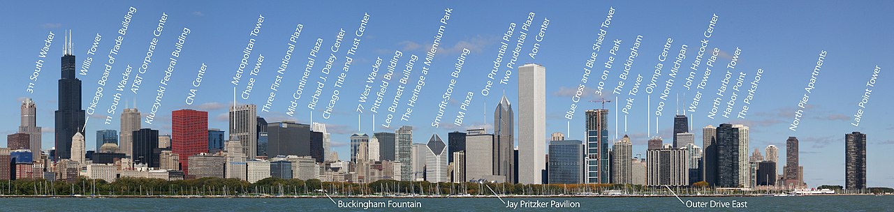
400 East Randolph Street Condominiums or simply 400 East Randolph (formerly Outer Drive East) is a 40-story high-rise in Chicago, Illinois, designed by Reinheimer & Associates. The building primarily consists of residential condominiums, though there are a few businesses and restaurants also located in the building. Situated on East Randolph Street on the New Eastside, the building sits between the Buckingham to its west and Harbor Point to its east. Two parks, Millennium Park and Lakeshore East Park, are immediately located to 400 East Randolph's south and north faces respectively. It is one of the buildings in the area that predates the new surrounding Lakeshore East development.

It was developed by Jerrold Wexler, who saw the legally protected lakefront as an ideal location for high income young office workers without children. In 1957, he encountered legal difficulties acquiring a lakefront site. Mayor Richard J. Daley, worried about a tendency of upscale Chicagoans to move to the suburbs, supported the project and told the planning department to make it work. The lakeshore was legally protected, but the city secured the needed legislation and resolved disputes with the Illinois Central Railroad, which originally owned the property. The city extended Randolph Drive into the lake area making the project possible. It was completed in 1962, as one of the largest apartment buildings in the world outside of New York City, with over 900 one-and two-bedroom units. It offered indoor parking, a pool and exercise facilities, a restaurant and a small grocery store. When it opened in 1962 The Chicago Sun-Times newspaper reported that Loop-area apartment towers such as Marina City, a few blocks away, "caught the city by surprise." A near-Loop location permitted one to walk to work at hundreds of office buildings, as well as walking access to the major department stores and theaters. In 1963 it became the first major apartment building in this part of downtown Chicago and started the trend of downtown living so that it is now surrounded by other upscale apartment and condominium buildings. However, after the 1970s, the amenities tended to leave the Loop and moved to North Michigan Avenue. It was converted from apartments to condominiums in 1973. [1] Today the building houses a few businesses including the Lakefront Children's Academy.

Position in Chicago's skyline

400 East Randolph (Outer Drive East) appears in front of Olympia Centre, 900 North Michigan, John Hancock Center, and Water Tower Place in the 2006 photo below.

Chicago skyline labelled.jpg311 South Wacker111 South WackerChase Tower77 West WackerIBM PlazaAon CenterBlue Cross and Blue Shield TowerPark TowerHarbor Point

Related Research Articles

<span class="mw-page-title-main">Chicago Loop</span> Community area in Chicago

The Loop, one of Chicago's 77 designated community areas, is the central business district of the city and is the main section of Downtown Chicago. Home to Chicago's commercial core, it is the second largest commercial business district in North America and contains the headquarters and regional offices of several global and national businesses, retail establishments, restaurants, hotels, and theaters, as well as many of Chicago's most famous attractions. It is home to Chicago's City Hall, the seat of Cook County, and numerous offices of other levels of government and consulates of foreign nations. The intersection of State Street and Madison Street, located in the area, is the origin of the address system of Chicago's street grid. Most of Grant Park's 319 acres (1.29 km2) are in the eastern section of the community area. The Loop community area is bounded on the north and west by the Chicago River, on the east by Lake Michigan, and on the south by Roosevelt Road.

<span class="mw-page-title-main">Hyde Park, Chicago</span> Community area of Chicago

Hyde Park is the 41st of the 77 community areas of Chicago. It is located on the South Side, near the shore of Lake Michigan 7 miles (11 km) south of the Loop.

<span class="mw-page-title-main">Michigan Avenue (Chicago)</span> Major north-south thoroughfare in Chicago, Illinois, United States

Michigan Avenue is a north-south street in Chicago which runs at 100 east on the Chicago grid. The northern end of the street is at Lake Shore Drive on the shore of Lake Michigan in the Gold Coast Historic District. The street's southern terminus is at Sibley Boulevard in the southern suburb of Harvey, though like many Chicago streets it exists in several disjointed segments.

<span class="mw-page-title-main">Lake Shore Drive</span> Lake-side expressway in Chicago, Illinois, United States

Lake Shore Drive is a multilevel expressway that runs alongside the shoreline of Lake Michigan, and adjacent to parkland and beaches, in Chicago. Except for the portion north of Foster Avenue, Lake Shore Drive is designated as part of U.S. Highway 41.

<span class="mw-page-title-main">Streeterville</span> Neighborhood in Chicago

Streeterville is a neighborhood in the Near North Side community area of Chicago, Illinois, United States, north of the Chicago River. It is bounded by the river on the south, the Magnificent Mile portion of Michigan Avenue on the west, and Lake Michigan on the north and east, according to most sources, although the City of Chicago only recognizes a small portion of this region as Streeterville. Thus, it can be described as the Magnificent Mile plus all land east of it. The tourist attraction of Navy Pier extends out into the lake from southern Streeterville. The majority of the land in this neighborhood is reclaimed sandbar.

<span class="mw-page-title-main">Edgewater, Chicago</span> Community area in Chicago

Edgewater is a lakefront community area on the North Side of the city of Chicago, Illinois six miles north of the Loop. The last of the city's 77 official community areas, Edgewater is bounded by Foster Avenue on the south, Devon Avenue on the north, Ravenswood Avenue on the west, and Lake Michigan on the east. Edgewater contains several beaches that residents enjoy during the late spring, summer, and early autumn. Chicago's largest park, Lincoln Park, stretches south from Edgewater for seven miles along the waterfront, almost to downtown. Historically, Edgewater was the northeastern corner of Lake View Township, an independent suburb annexed by the city of Chicago in 1889. Today, the Uptown community is to Edgewater's south, Lincoln Square to its west, West Ridge to its northwest and Rogers Park to its north.

<span class="mw-page-title-main">Near North Side, Chicago</span> Community area in Chicago

The Near North Side is the eighth of Chicago's 77 community areas. It is the northernmost of the three areas that constitute central Chicago, the others being the Loop and the Near South Side. The community area is located north and east of the Chicago River. To its east is Lake Michigan, and its northern boundary is the early 19th-century city limit of Chicago, North Avenue. In 2020 the Near North Side had 105,481 residents, surpassing Lake View as the largest Chicago community area by population. It is also the most densely populated community area and has the second most skyscrapers, after the Loop. With the exception of Goose Island, the Near North Side is known for its extreme affluence, typified by the Gold Coast, Magnificent Mile, Navy Pier, and skyscrapers.

<span class="mw-page-title-main">900 North Michigan</span> Supertall skyscraper located in Chicago Illinois

900 North Michigan in Chicago, in the U.S. state of Illinois, is a skyscraper completed in 1989. At 871 feet tall, it is currently the ninth-tallest building in Chicago and the 31st-tallest in the United States. It was developed by Urban Retail Properties in 1988 as an upscale sister to Water Tower Place, one block southeast, and was the second vertical mall built along the Magnificent Mile.

<span class="mw-page-title-main">Near South Side, Chicago</span> Community area in Chicago

The Near South Side is a community area of Chicago, Illinois, United States, just south of the downtown central business district, the Loop. The Near South Side's boundaries are as follows: North—Roosevelt Road ; South—26th Street; West—Chicago River between Roosevelt and 18th Street, Clark Street between 18th Street and Cermak Road, Federal between Cermak Road and the Stevenson Expressway just south of 25th Street, and Clark Street again between the Stevenson and 26th Street; and East—Lake Michigan.

<span class="mw-page-title-main">Magnificent Mile</span> Neighborhood and street in Cook, Illinois, United States

The Magnificent Mile, sometimes referred to as The Mag Mile, is an upscale section of Chicago's Michigan Avenue, running from the Chicago River to Oak Street in the Near North Side. The district is located within downtown, and one block east of Rush Street. The Magnificent Mile serves as the main thoroughfare between Chicago's Loop business district and its Gold Coast. It is generally the western boundary of the Streeterville neighborhood, to its east and River North to the west.

<span class="mw-page-title-main">Chicago Pedway</span>

The Chicago Pedway is a network of tunnels, ground-level concourses and bridges connecting skyscrapers, retail stores, hotels, and train stations throughout the central business district of Chicago, Illinois.

<span class="mw-page-title-main">Randolph Street</span> Street in Chicago, USA

Randolph Street is a street in Chicago. It runs east–west through the Chicago Loop, carrying westbound traffic west from Michigan Avenue across the Chicago River on the Randolph Street Bridge, interchanging with the Kennedy Expressway (I-90/I-94), and continuing west. It serves as the northern boundary of Grant Park and the Chicago Landmark Historic Michigan Boulevard District. Several large theaters, as well as city and state government buildings are on and adjacent to Randolph. Metra's Millennium Station is located under Randolph Street.

<span class="mw-page-title-main">Lakeshore East</span> Human settlement in Chicago, Illinois

Lakeshore East is a master-planned mixed use urban development being built by the Magellan Development Group in the Loop community area of Chicago in Cook County, Illinois, United States. It is located in the northeastern part of the Loop, which, along with Illinois Center, is called the New Eastside. The development is bordered by Wacker Drive to the north, Columbus Drive to the west, Lake Shore Drive to the east, and East Randolph Street to the south. Skidmore, Owings & Merrill created the master plan for the area. The development, which had been scheduled for completion in 2011, was set for completion in 2013 by 2008. Development continued with revised plans for more buildings in 2018 and continuing construction of the Vista Tower in 2019.

<span class="mw-page-title-main">Millennium Station</span> Commuter rail terminal in downtown Chicago, Illinois, USA

Millennium Station is a major commuter rail terminal in the Loop (downtown), Chicago. It is the northern terminus of the Metra Electric District to Chicago's southern suburbs, and the western terminus of the South Shore Line to Gary and South Bend, Indiana.

<span class="mw-page-title-main">Lake Point Tower</span> Residential skyscraper in Chicago, Illinois

Lake Point Tower is a residential skyscraper located on a promontory of the Lake Michigan waterfront in Chicago, just north of the Chicago River at 505 North Lake Shore Drive. Completed in 1968, it is in the Streeterville neighborhood on the Near North Side. Located adjacent to Navy Pier, the building is the only skyscraper in the city east of Lake Shore Drive.

<span class="mw-page-title-main">The Buckingham (Chicago)</span> Residential condos in Chicago, Illinois

The Buckingham, formerly known as Buckingham Plaza, is a 44-story all-residential condominium designed by Fujikawa Johnson & Associates. Located on East Randolph Street in Chicago, Illinois, the building sits between the new 340 on the Park building to its west and the older Outer Drive East building to its east. Two parks, Millennium Park and Lakeshore East Park, are immediately located to The Buckingham's south and north faces respectively. It is one of the few buildings that predates the new surrounding Lakeshore East development in the New Eastside neighborhood.

<span class="mw-page-title-main">Historic Michigan Boulevard District</span> Historic district of Chicago, Illinois, United States

The Historic Michigan Boulevard District is a historic district in the Loop community area of Chicago in Cook County, Illinois, United States encompassing Michigan Avenue between 11th or Roosevelt Road, depending on the source, and Randolph Streets and named after the nearby Lake Michigan. It was designated a Chicago Landmark on February 27, 2002. The district includes numerous significant buildings on Michigan Avenue facing Grant Park. In addition, this section of Michigan Avenue includes the point recognized as the end of U.S. Route 66. This district is one of the world's best known one-sided streets rivalling Fifth Avenue in New York City and Edinburgh's Princes Street. It lies immediately south of the Michigan–Wacker Historic District and east of the Loop Retail Historic District.

<span class="mw-page-title-main">Hyatt Regency Chicago</span> Building in Chicago, Illinois

The Hyatt Regency Chicago is a 365-foot-tall (111 m) Hyatt hotel on East Wacker Drive in Chicago, Illinois. The hotel operates over 2,019 guest rooms in two different towers which were constructed in 1974 and 1980. The towers are connected by both an above-ground skyway and an underground concourse. This underground concourse is considered to be part of the Chicago Pedway. The hotel has a multi-level conference center which includes a 25,000-square-foot (2,300 m2) ballroom, and 85,000 square feet (7,900 m2) of meeting space. The conference center has been home to such events as the 40th, 49th, 58th, 70th and 80th World Science Fiction Conventions in 1982, 1991, 2000, 2012, and 2022 respectively.

<span class="mw-page-title-main">Lakeshore East Building I</span> Planned skyscraper

Lakeshore East Building I is the address of the as-yet unnamed skyscraper that is part of the 2018 revision of the Lakeshore East development masterplan. The property is located immediately south of Wacker Drive and immediately west of Lake Shore Drive with a potential address of 300 North Lake Shore Drive. The property was approved as part of the Lakeshore East masterplan with a 950-foot (290 m) height.

References

  1. Joseph P. Schwieterman; Dana M. Caspall (2006). The Politics of Place: A History of Zoning in Chicago. Lake Claremont Press. p. 82.
from BP Pedestrian Bridge Downtown Chicago Illinois Nov05 img 2574.jpg
from BP Pedestrian Bridge