98 B-Line

Last updated
98 B-Line
B-Line-R8063.jpg
98 B-Line bus on Anderson Road
Overview
System TransLink
Operator Coast Mountain Bus Company
Vehicle New Flyer Industries D60LF
Began serviceSeptember 4, 2000
Ended serviceSeptember 7, 2009
Route
Start Burrard Station
End Brighouse (Steveston & Shell, evenings and morning only)
Length16 km (9.9 mi)
Stops22
 {{{previous_line}}} {{{system_nav}}} {{{next_line}}} 

The 98 B-Line was a bus rapid transit line [1] [2] in Metro Vancouver, British Columbia, Canada, that began service in September 2000. It linked Richmond to Downtown Vancouver, with a connection to Vancouver International Airport. It travelled mainly along Granville Street in Vancouver and a dedicated bus lane on No. 3 Road in Richmond. It was operated by Coast Mountain Bus Company and was funded by TransLink. The route was 16 kilometres (9.9 mi) long. The line carried over 18,000 passengers daily. [3] It was discontinued in September 2009, shortly after the opening of the Canada Line, which replaced it.

Contents

Typical 98 B-Line stop information poster 98b-line-sign.jpg
Typical 98 B-Line stop information poster

History

Prior to the introduction of the 98 B-Line, most bus routes in Richmond travelled into Downtown Vancouver during rush hours. These routes served all stops along their routes in Richmond, then would operate along Granville Street in Vancouver as express services.

Although the idea of a rapid bus line from Richmond to Vancouver had been discussed for decades, it was first proposed by BC Transit in 1994. In 1995, Vancouver city council approved a southbound high-occupancy vehicle lane for the evening peak hours in the Marpole neighbourhood in preparation for an express bus service. In 1997, the idea of a rapid transit line was re-introduced with the objective of providing the express service at regular fares. A study determined that the best route for the line would be via Granville Street in Vancouver. [4]

A typical 98 B-Line stop (from Seymour & Davie) 98b-linestop.jpg
A typical 98 B-Line stop (from Seymour & Davie)

The project cost approximately CA$52 million to build; [3] this included the price of new vehicles, the construction of a dedicated bus lane in Richmond, installing new bus shelters, automated on-board announcements and similar technology, transit priority systems for traffic lights and a share of the new Richmond bus depot, as the old Vancouver Oakridge depot could not accommodate the longer 18-metre (60 ft) articulated buses used on the route. [5] The line opened as far as Sea Island on September 4, 2000, [6] later extending from Airport Station into central Richmond in August 2001. [7]

The introduction of the B-Line eliminated most other local bus services that travelled between Richmond and Vancouver, requiring a transfer between buses for most commuters. As a result of the added transfer and quicker travel times of the B-Line that did not materialize, commute times for passengers increased even though a commute time savings of several minutes had been promised. Within a few years, this prompted improved rush hour services on remaining Richmond to Vancouver routes.

The B-line was one of the most used routes in the TransLink system. In early 2001, the Richmond/Airport-Vancouver Rapid Transit Project feasibility study, which examined replacing the 98 B-Line with light rail, held open houses. [8] This proposed line's working name was the "RAV Line" (Richmond–Airport–Vancouver). The estimated cost of $1.72 billion generated much controversy. Richmond city council, which favoured an at-grade line within the city limits for aesthetic reasons, also threatened the project. However, the city backed down because an elevated line was both preferred by the public, and offered faster trip times and lower operating costs. The TransLink board twice rejected the project because board members representing the northeast areas of Greater Vancouver wanted a line built to Coquitlam. The "RAV Line" project was saved after the board agreed to build both lines by 2010. [9] While not part of the 2010 Winter Olympics in Vancouver, the Canada Line, completed in August 2009, replaced the 98 B-Line.

Beginning in February 2008, 98 B-Line route passengers with valid proof of payment were permitted to board using any of the three doors at any stop. To facilitate this, the bus driver controlled the operation of all three doors at each of the stops. Passengers paying cash or validating FareSavers had to board through the front door.

The 98 B-Line was discontinued on September 7, 2009, two and a half weeks after the Canada Line opened. Afterwards, the #10 Hastings/Downtown/Granville bus began running more frequently along Granville street to compensate. [10]

Features

The 98 featured GPS technology, automated stop announcements, specialized bus stop displays that showed the amount of time until the next bus arrives, and special traffic light signals that sustained green lights long enough for buses to pass through.

In Richmond, the 98 B-Line followed a dedicated bus lane separated from mainstream traffic on No. 3 Road, between the Lansdowne and Sea Island Way stops. On February 13, 2006, the 98 B-Line's bus lane in Richmond was closed as utility crews prepared for the construction of the Canada Line along No. 3 Road. Between February 2006 until its discontinuation in September 2009, the 98 B-Line travelled with regular traffic.

98 B-Line stops and transfer points

98 B-Line
BSicon WDOCKSlf.svg
BSicon WDOCKSm.svg
BSicon WDOCKSm.svg
BSicon WDOCKSrf.svg
BSicon lHST yellow.svg
BSicon HUBaq.svg
BSicon uKBHFa.svg
BSicon nKHSTa green.svg
BSicon KBHFe brown.svg
BSicon KBHFa violet.svg
BSicon uSTR.svg
BSicon nSTR green.svg
BSicon nSTRl green.svg
BSicon nSTR+r green.svg
BSicon CONTf violet.svg
Burrard
BSicon lHST yellow.svg
BSicon HUBaq.svg
BSicon uBHF.svg
BSicon nHST green.svg
BSicon nSTR green.svg
BSicon uSTRl.svg
BSicon uSTRq.svg
BSicon uSTRq.svg
BSicon uSTR+r.svg
BSicon nSTR green.svg
BSicon nHST green.svg
BSicon lHST yellow.svg
BSicon HUBeq.svg
BSicon uBHF.svg
Burrard & Robson
BSicon nHST green.svg
BSicon nSTR green.svg
BSicon uCONTf.svg
Nelson & Hornby
BSicon nHST green.svg
Seymour & Smithe
Howe & Davie
BSicon nHST green.svg
Seymour & Davie
BSicon nSTR green.svg
BSicon nSTR+l green.svg
BSicon nSTRr green.svg
BSicon WASSERq.svg
BSicon hnKRZWae green.svg
BSicon WASSERq.svg
BSicon WASSERq.svg
5th Avenue
BSicon nHST green.svg
BSicon nCONTl+f orange.svg
Arrow Blue Left 001.svg
99 B-Line
to UBC Loop
BSicon nCONTgq orange.svg
BSicon nSTRq orange.svg
BSicon nHSTq orange.svg
BSicon nSTRr orange.svg
BSicon nHST green.svg
King Edward
BSicon nHST green.svg
41st Avenue
BSicon nHST green.svg
49th Avenue
BSicon nHST green.svg
70th Avenue
BSicon WASSERq.svg
BSicon hnKRZWae green.svg
BSicon WASSERq.svg
BSicon WASSERq.svg
Airport Station
BSicon nHST green.svg
BSicon WASSERq.svg
BSicon hnKRZWae green.svg
BSicon WASSERq.svg
BSicon WASSERq.svg
BSicon nHST green.svg
Sea Island Way
BSicon nHST green.svg
Capstan Way
BSicon nHST green.svg
Aberdeen
BSicon nHST green.svg
Alderbridge
BSicon nHST green.svg
Lansdowne
BSicon nHST green.svg
Westminster Highway
BSicon nHST green.svg
Richmond Centre
BSicon nKHSTe green.svg
Brighouse
Legend
BSicon BUS.svg
BSicon nSTRq green.svg
BSicon nHSTq green.svg
BSicon nSTRq green.svg
98 B-Line (Bus)
BSicon ICTS.svg
BSicon TRAIN2.svg
BSicon uSTRq.svg
BSicon uBHFq.svg
BSicon uSTRq.svg
Expo/Millennium Line (SkyTrain)
BSicon TRAIN3.svg
BSicon STRq violet.svg
BSicon BHFq violet.svg
BSicon STRq violet.svg
West Coast Express (Commuter Rail)
BSicon BOOT.svg
BSicon STRq brown.svg
BSicon BHFq brown.svg
BSicon STRq brown.svg
SeaBus (Passenger-only Ferry)
BSicon BUS.svg
BSicon nSTRq orange.svg
BSicon nHSTq orange.svg
BSicon nSTRq orange.svg
99 B-Line (Bus)
Fare Zone 1
Fare Zone 2

Downtown Vancouver

Vancouver

Richmond

The stop for Richmond Centre Richmond-ctr-bline.jpg
The stop for Richmond Centre
Demolition of the former 98 B-Line busway between Sea Island Way and Lansdowne stations on No. 3 Road, in preparation for the construction of the Canada Line 98laneclosed.jpg
Demolition of the former 98 B-Line busway between Sea Island Way and Lansdowne stations on No. 3 Road, in preparation for the construction of the Canada Line

Route notes

See also

Related Research Articles

<span class="mw-page-title-main">British Columbia Electric Railway</span>

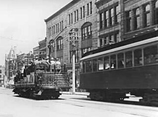
The British Columbia Electric Railway (BCER) was an historic railway which operated in southwestern British Columbia, Canada. Originally the parent company for, and later a division of, BC Electric Company, the BCER assumed control of existing streetcar and interurban lines in southwestern British Columbia in 1897, and operated the electric railway systems in the region until the last interurban service was discontinued in 1958. During and after the streetcar era, BC Electric also ran bus and trolleybus systems in Greater Vancouver and bus service in Greater Victoria; these systems subsequently became part of BC Transit, and the routes in Greater Vancouver eventually came under the control of TransLink. Trolley buses still run in the City of Vancouver with one line extending into Burnaby.
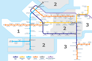
<span class="mw-page-title-main">Waterfront station (Vancouver)</span> Metro Vancouver public transportation facility

Waterfront station is a major intermodal public transportation facility and the main transit terminus in Vancouver, British Columbia, Canada. It is located on West Cordova Street in Downtown Vancouver, between Granville and Seymour Street. The station is also accessible via two other street-level entrances, one on Howe Street to the west for direct access to the Expo Line and another on Granville Street to the south for direct access to the Canada Line.

<span class="mw-page-title-main">Burrard station</span> Metro Vancouver SkyTrain station

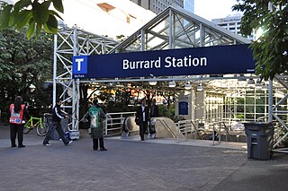
Burrard is an underground station on the Expo Line of Metro Vancouver's SkyTrain rapid transit system. The station is located in Downtown Vancouver on Burrard Street, where Melville and Dunsmuir Streets meet, and is the western terminus of the R5 Hastings St that provides service to Simon Fraser University.

<span class="mw-page-title-main">Granville station (SkyTrain)</span> Metro Vancouver SkyTrain station

Granville is an underground station on the Expo Line of Metro Vancouver's SkyTrain rapid transit system. The station is located in Downtown Vancouver on the portion of Granville Street that is known as the Granville Mall. The station is accessible from the surface via entrances on Granville Street and Seymour Street, and the Dunsmuir entrance between Granville and Seymour.

<span class="mw-page-title-main">99 B-Line</span> Express bus service in Metro Vancouver, Canada

The 99 B-Line is an express bus line with bus rapid transit elements in Metro Vancouver, British Columbia, Canada. It travels along Broadway, a major east–west thoroughfare, and connects the University of British Columbia (UBC) to Commercial–Broadway station on the SkyTrain system. It is operated by Coast Mountain Bus Company and funded by TransLink.

<span class="mw-page-title-main">Airport station (TransLink)</span>

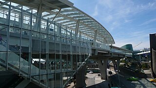
Airport station was a TransLink public transit exchange on Sea Island, Richmond, in Metro Vancouver. Most bus operations using the location ceased September 7, 2009, two and a half weeks after the opening of the Canada Line, when the exchange downgraded to a regular bus stop.

<span class="mw-page-title-main">Downtown Vancouver</span> Neighbourhood of Vancouver in British Columbia, Canada

Downtown Vancouver is the central business district and the city centre neighbourhood of Vancouver, Canada, on the northwestern shore of the Burrard Peninsula in the Lower Mainland region of British Columbia. It occupies most of the north shore of the False Creek inlet, which cuts into the Burrard Peninsula creating the Downtown Peninsula, where the West End neighbourhood and Stanley Park are also located.

<span class="mw-page-title-main">Transportation in Vancouver</span>

Transportation in Vancouver, British Columbia, has many of the features of modern cities worldwide. Unlike many large metropolises, Vancouver has no freeways into or through the downtown area. A proposed freeway through the downtown was rejected in the 1960s by a coalition of citizens, community leaders and planners. This event "signalled the emergence of a new concept of the urban landscape" and has been a consistent element of the city's planning ever since.

<span class="mw-page-title-main">Richmond–Brighouse station</span> Metro Vancouver SkyTrain station

Richmond–Brighouse is an elevated station on the Canada Line of Metro Vancouver's SkyTrain rapid transit system. Located in the Brighouse area of Richmond, British Columbia, Canada, it is one of the outbound terminus stations of the Canada Line, the other being YVR–Airport. Like YVR–Airport, Richmond–Brighouse only has a single track.

<span class="mw-page-title-main">Bridgeport station (SkyTrain)</span> Metro Vancouver SkyTrain station

Bridgeport is an elevated station on the Canada Line of Metro Vancouver's SkyTrain rapid transit system. It is located in Richmond, British Columbia, Canada, south of Vancouver. The Canada Line branches outbound at this station, with one branch heading westward to YVR–Airport station at the Vancouver International Airport and the other heading south to Richmond–Brighouse station in the commercial centre of Richmond.

<span class="mw-page-title-main">YVR–Airport station</span> Metro Vancouver SkyTrain station

YVR–Airport is an elevated station on the Canada Line of Metro Vancouver's SkyTrain rapid transit system. The station is located at Vancouver International Airport's main terminal in Richmond, British Columbia, and is one of the outbound termini of the Canada Line, the other being Richmond–Brighouse.

<span class="mw-page-title-main">Marine Drive station</span> Metro Vancouver SkyTrain station

Marine Drive is an elevated station on the Canada Line of Metro Vancouver's SkyTrain rapid transit system. The station is located at the intersection of Cambie Street and SW Marine Drive in Vancouver, British Columbia.

<span class="mw-page-title-main">King Edward station</span> Metro Vancouver SkyTrain station

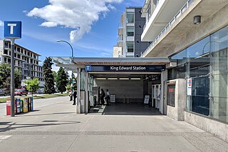
King Edward is an underground station on the Canada Line of Metro Vancouver's SkyTrain rapid transit system. The station is located at the intersection of Cambie Street and King Edward Avenue in Vancouver, British Columbia, Canada, and serves the neighbourhoods of Riley Park–Little Mountain and South Cambie. The station is within walking distance of BC Children's Hospital, Nat Bailey Stadium, and Queen Elizabeth Park.

<span class="mw-page-title-main">Marpole Loop</span>

Marpole Loop is a public transit exchange in the Marpole neighbourhood of Vancouver, British Columbia, Canada. The exchange is a part of Metro Vancouver's TransLink transit network. It is the southernmost transit exchange located within the city of Vancouver.

<span class="mw-page-title-main">R4 41st Ave</span> Express bus service in Metro Vancouver, Canada

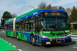
The R4 41st Ave is an express bus route with bus rapid transit elements in Metro Vancouver, British Columbia, Canada. Part of TransLink's RapidBus network, it replaced the 43 Express that travelled along 41st Avenue, a major east–west route that connects the University of British Columbia (UBC) to the SkyTrain system's Oakridge–41st Avenue station on the Canada Line and Joyce–Collingwood station on the Expo Line.

<span class="mw-page-title-main">R5 Hastings St</span> Express bus service in Metro Vancouver, Canada

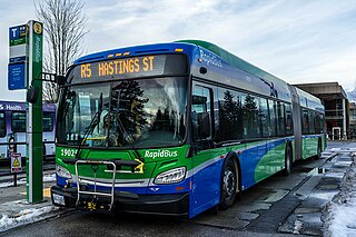
The R5 Hastings St is an express bus service with bus rapid transit elements in Metro Vancouver, Canada. Part of TransLink's RapidBus network, it travels along Hastings Street, a major east–west route, and connects Simon Fraser University to the SkyTrain system's Burrard station on the Expo Line in Downtown Vancouver. It replaced the 95 B-Line route on January 6, 2020.

<span class="mw-page-title-main">Brighouse, Richmond</span> Neighbourhood in Richmond, British Columbia

Brighouse is a neighbourhood that comprises most of the urban core of Richmond in Metro Vancouver. The area includes community facilities, civic offices, Richmond Centre, and the Canada Line Richmond–Brighouse station terminus.

<span class="mw-page-title-main">R1 King George Blvd</span> Express bus service in Metro Vancouver, Canada

The R1 King George Blvd is an express bus service with bus rapid transit elements in Metro Vancouver, British Columbia, Canada. Part of TransLink's RapidBus network, it travels along King George Boulevard and 104 Avenue in Surrey and connects Guildford, Whalley / City Centre, and Newton. The service replaced the 96 B-Line on January 6, 2020. It is operated by Coast Mountain Bus Company and funded by TransLink.

<span class="mw-page-title-main">R2 Marine Dr</span> Express bus service in Metro Vancouver, Canada

The R2 Marine Dr is an express bus service with bus rapid transit elements in Metro Vancouver, British Columbia, Canada. Part of TransLink's RapidBus network, it travels along Marine Drive, 3rd Street, Cotton Road, and Main Street in North Vancouver and connects major North Shore transit points Park Royal Exchange, Lonsdale Quay, and Phibbs Exchange.

References

  1. "Intelligent Transportation Systems in 98 B-Line Rapid Bus Service: Advanced Technology at Work" (PDF). Federation of Canadian Municipalities. Transport Canada. Retrieved January 28, 2017.
  2. "4.6 Intelligent Transportation Systems [ITS] – #98B-Line Bus Rapid Transit Evaluation Study (Quick View)". TransLink. Archived from the original on February 2, 2017. Retrieved January 28, 2017.
  3. 1 2 Mills, Brian. "Bus Rapid Transit in Vancouver: A Review of Experience" (PDF). TransLink. Archived from the original (PDF) on March 14, 2006.
  4. Hudberg, D. H. (February 23, 1998). "City of Vancouver Memorandum Re: Richmond Rapid Bus". City of Vancouver. Archived from the original on August 10, 2011.
  5. "98 B-Line Bus Rapid Transit Evaluation Study" (PDF). Archived from the original (PDF) on 2006-12-09. Retrieved 2006-09-14.
  6. "The Buzzer, 1 Sep 2000" (PDF). www.translink.ca. TransLink.
  7. "The Buzzer, 8 Aug 2001" (PDF). www.translink.ca. TransLink.
  8. "Richmond Review, 18 Mar 2001". www.newspapers.com. p. 22. The Richmond/Airport-Vancouver Rapid Transit Project is currently assessing whether there is a need to build a rapid transit line that connects Richmond City Centre, the Airport, and downtown Vancouver in the next ten years.
  9. "RAV line gets final approval, construction to start in 2005". Vancouver Sun. December 2, 2004. Archived from the original on January 21, 2005.
  10. "Connecting Transit Services". TransLink. Archived from the original on August 9, 2009. Retrieved July 29, 2009.