DeKalb County is a county located in the northeastern part of the U.S. state of Alabama. As of the 2020 census, the population was 71,608. Its county seat is Fort Payne, and it is named after Major General Baron Johan DeKalb. DeKalb County is part of the Huntsville-Decatur-Albertville, AL Combined Statistical Area.

Alexandria is a census-designated place and unincorporated community in Calhoun County, Alabama, United States. At the 2020 census, the population was 4,032. It is included in the Anniston–Oxford, Alabama Metropolitan Statistical Area.
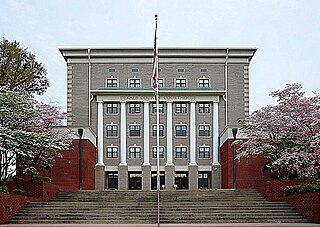
Fort Payne is a city in and county seat of DeKalb County, in northeastern Alabama, United States. At the 2020 census, the population was 14,877.

Pine Ridge is a town in DeKalb County, Alabama, United States. It incorporated in 1982. At the 2020 census, the population was 263.
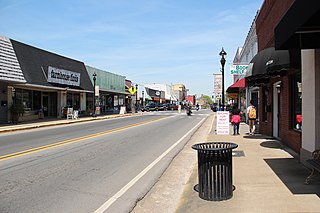
Rainsville is a city in DeKalb County, Alabama, United States. At the 2010 census the population was 4,948, up from 4,499 in 2000. Rainsville is located on top of Sand Mountain, a southern extension of the Cumberland Plateau.
Adamana is an unincorporated community in Apache County in the northeast section of the U.S. state of Arizona. The town was settled in 1896 in what was then the Arizona Territory.

Ackerville is an unincorporated community in Wilcox County, Alabama, United States. Ackerville has one site included on the National Register of Historic Places, the Ackerville Baptist Church of Christ.
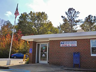
Alpine is an unincorporated community in Talladega County, Alabama, United States, located southwest of Talladega and northwest of Childersburg. It is known to Alabama residents as the site of YMCA Camp Cosby. The community gained its name from Alpine, a plantation owned by the Welch family. Over time, a town grew up around the plantation when a railroad came through. Initially known as Welchs Depot, it eventually came to be known as Alpine, in honor of the plantation.

Allsboro is a populated place in Colbert County, Alabama, United States. This unincorporated community is located in the far western area of the county, about 9 miles (14 km) southwest of the town of Cherokee, near the Mississippi state border.
Arkadelphia is an unincorporated community in Cullman County, Alabama, United States.

Alabama Port, also sometimes known as Port Alabama, is an unincorporated community on Mon Louis Island, in Mobile County, Alabama, United States.

Arbacoochee is an unincorporated community in Cleburne County, Alabama, United States.
Almond, also known as Flat Rock, is an unincorporated community in Randolph County, Alabama, United States.
Acmar is a former unincorporated community and neighborhood within the city of Moody in St. Clair County, in the U.S. state of Alabama.
Acton is an unincorporated community in Shelby County, in the U.S. state of Alabama. It is partially located within the city of Hoover. It is not to be confused with the village of Acton, approximately 6+1⁄2 miles to the northeast in Jefferson County.
Arguta is an unincorporated community in Dale County, Alabama, United States.
Abernathy is an unincorporated community in Cleburne County, Alabama, United States

Alabama City is a former city and now a neighborhood within the city of Gadsden in Etowah County, Alabama, United States. It was equidistant between Gadsden and Attalla, Alabama, approximately 2 1/2 miles west of downtown Gadsden.

Allenton is an unincorporated community in Wilcox County, Alabama, United States.
Acton is an unincorporated community in Jefferson County, in the U.S. state of Alabama. It is a suburban area bordering the city of Birmingham, centered around the intersection of Caldwell Mill Road and Old Looney Mill Road just west of the Cahaba River. It is not to be confused with the former mining village of Acton, Alabama in Shelby County (now within the city of Hoover, approximately 6+1⁄2 miles to the southwest as the crow flies. Initially, this Acton was also in Shelby County before a border adjustment shifted it into Jefferson County.

