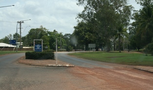
Weipa is a coastal mining town in the local government area of Weipa Town in Queensland, Australia. It is the largest town on the Cape York Peninsula. It exists because of the enormous bauxite deposits along the coast. The Port of Weipa is mainly involved in exports of bauxite. There are also shipments of live cattle from the port.

The City of Port Lincoln is a local government area located on the southern tip of the Eyre Peninsula in South Australia. It consists of one suburb - Port Lincoln. It is surrounded on land by the District Council of Lower Eyre Peninsula, which also has offices in Port Lincoln.

The District Council of Lower Eyre Peninsula is a local government area located on Eyre Peninsula in South Australia. The district covers the southern tip of the peninsula, except for the small area taken up by the City of Port Lincoln.

Bonython Park is a 17-hectare park in the north-west Park Lands of the South Australian capital of Adelaide. The park was opened in 1962 and named in honour of prominent South Australian politician and journalist, Sir John Langdon Bonython. It is situated on north-western side of the River Torrens, bordered by Port Road. It is on the opposite side of the river to a golf course, and adjacent to the old Adelaide Gaol and the Police Barracks.
Dandalup River is one of the shortest rivers in Western Australia. It begins at the confluence of the South Dandalup River and the North Dandalup River north of Pinjarra, and flows for just four kilometres before emptying into the Murray River.

Sepia novaehollandiae is a species of cuttlefish native to the southern Indo-Pacific. Its natural range stretches from Shellharbour, New South Wales to North West Shelf in Western Australia. It lives at depths of between 15 and 348 m.

Matthew Moorhouse was an English pioneer in Australia, pastoralist, politician, and Protector of Aborigines in South Australia. He led the Rufus River massacre, where he and his men murdered 30-40 Maraura men, women and children.

The Gerard Community Council is a small, aboriginally controlled local government area located in The Riverland, South Australia. The community is dependent on the River Murray, with some horticulture and grazing in the district. Traditional crafts are also produced in the community, with part of the community economy derived from the sale of these to tourists.

Walhallow is a village in the North West Slopes region of New South Wales, Australia, near the Mooki River. The town is in the south east corner of Gunnedah Shire local government area, 370 kilometres (230 mi) north west of the state capital, Sydney and 34 kilometres (21 mi) west of the nearest sizeable town, Quirindi. At the 2006 census, the village with neighbouring Caroona had a population of 179.

The County of Flinders is one of the 49 cadastral counties of South Australia. The county covers the southern part of the Eyre Peninsula “bounded on the north by a line connecting Point Drummond with Cape Burr, and on all other sides by the seacoast, including all islands adjacent to the main land.”
The Mizar Nunataks are a small cluster of rock nunataks near the Antarctic polar plateau, 12 nautical miles (22 km) south of the Wilhoite Nunataks. They were named by the Advisory Committee on Antarctic Names after the USNS Mizar, a cargo vessel in the U.S. convoy to McMurdo Sound in U.S. Navy Operation Deep Freeze, 1962.

Barngarla, formerly known as Parnkalla, is an Aboriginal language of Eyre Peninsula, South Australia, Australia.

North Shields is a town on the east coast of Eyre Peninsula, overlooking Boston Bay in Spencer Gulf in South Australia. In 2011 it had a population of 503. It is 11 km (6.8 mi) north of Port Lincoln.

Liguanea Island is an uninhabited granite island located 3.7 km south of Cape Carnot at the southern, central point of Eyre Peninsula, South Australia. It is approximately 2.7 km long, 180 ha in size its elevation above sea level is estimated to be 43 metres. It is approximately 35 km south-west of Port Lincoln in the Great Australian Bight. The island forms part of the Lincoln National Park.

Grantham Island is an uninhabited island occupying 51 ha of Proper Bay, Spencer Gulf, South Australia. The nearest geographical feature on the mainland is Murray Point, which is also undeveloped. The island was named by explorer Matthew Flinders on 25 February 1802, after the municipal and parliamentary borough of Grantham, Lincolnshire, England. It lies 3 km south of the Port Lincoln marina and is well vegetated.

Mikkira Station is a pastoral lease that operates as a sheep station in South Australia.

Poonindie is a small township near Port Lincoln on the Eyre Peninsula, South Australia.

Davenport is a suburb in the Australian state of South Australia located about 282 kilometres (175 mi) north of the state capital of Adelaide and about 4 kilometres (2.5 mi) north-east of the municipal seat in Port Augusta.

The Hundred of Warrow is a cadastral hundred of the County of Flinders, South Australia. The hundred was proclaimed in 1869. It is bisected east from west by the Flinders Highway, north of Port Lincoln. The main centre of population in the hundred is the town of Coulta. The traditional owners of the district are the Nauo Indigenous Australians.
The Nauo (Nawu) were an indigenous Australian people of South Australia who spoke the Nauo language. They became extinct by the end of the nineteenth century.


