Akron, Illinois | |
|---|---|
 Akron, Illinois  Akron, Illinois | |
| Coordinates: 40°54′14″N89°39′14″W / 40.90389°N 89.65389°W | |
| Country | United States |
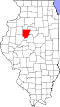
| State | Illinois |
| County | Peoria |
| Elevation | 722 ft (220 m) |
| Time zone | UTC-6 (Central (CST)) |
| • Summer (DST) | UTC-5 (CDT) |
| Area code | 309 |
| GNIS feature ID | 422393 [1] |
Akron is an unincorporated community in Akron Township, Peoria County, in the U.S. state of Illinois. [1]