Trivoli, Illinois | |
|---|---|
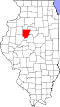
 Trivoli, Illinois in Illinois  Trivoli, Illinois Trivoli, Illinois (the United States) | |
| Coordinates: 40°41′45″N89°52′50″W / 40.69583°N 89.88056°W [1] | |
| Country | United States |
| State | Illinois |
| County | Peoria |
| Area | |
• Total | 1.52 sq mi (3.94 km2) |
| • Land | 1.52 sq mi (3.94 km2) |
| • Water | 0 sq mi (0.00 km2) |
| Elevation | 751 ft (229 m) |
| Population (2020) | |
• Total | 385 |
| • Density | 252.9/sq mi (97.66/km2) |
| Time zone | UTC-6 (Central (CST)) |
| • Summer (DST) | UTC-5 (CDT) |
| ZIP code | 61569 |
| Area code | 309 |
| GNIS feature ID | 2804097 [1] |
Trivoli is an Census Designated Place in Peoria County, Illinois, United States, on Illinois Route 116 east of Farmington. Trivoli has a part-time post office. [3]