Albany Island

Last updated

Albany Island
Native name:
Pabaju
Manar Islands (Landsat).png
Albany Island (Pictured in center)
Somerset, Albany Island.jpg
Admiralty Plan No. 1937. Plan drawn in 1862 showing site on Albany Island advised for the proposed Cape York Station, and the best position for the township on the mainland opposite.
Geography
Archipelago Torres Strait Islands
Length6 km (3.7 mi)
Administration

Albany Island or Pabaju is an island off the north-eastern coast of Cape York Peninsula in the Adolphus Channel of Queensland, Australia. It is within the locality of Somerset in the Shire of Torres. [1]

Contents

Geography

Albany Island is off the north-eastern coast in the Cape York Peninsula about 20 km (12 mi) East of Bamaga, and 6 km (3.7 mi) southeast of the tip of Cape York. It is separated from the peninsula by the Albany Passage ( 10°44′21″S142°36′00″E / 10.7392°S 142.6000°E / -10.7392; 142.6000 (Albany Passage) ). [2] [3] [4]

The island is a part of the Maner group of islands and the Torres Strait Islands; it is about 6 km (3.7 mi) long and is volcanic with fringing coral reefs. [5] [4] It is said to have been certainly part of the territory of the Djagaraga or Gudang people. [6]

The island was surveyed in 1848 by Owen Stanley RN and part of the island was named Port Albany ( 10°43′58″S142°36′01″E / 10.7327°S 142.6004°E / -10.7327; 142.6004 (Port Albany) ). [7]

A bêche-de-mer station was established on the island in 1862 by C. Edwards and J. Frazer. [8] After an inspection by Queensland's Governor Bowen, a settlement was planned for the island but it was built instead on the adjacent mainland in 1863 at Somerset, Queensland. There was still a trochus shell farm there in 1995, [9] and there is now an operational pearl farm. [10]

The wreck of the RMS Quetta, a passenger ship that sank in 1890, lies just off Albany Island. The ship hit an uncharted rock and sank in a very short time killing 134 people. [11]

History

Djagaraga (also known as Yadhaigana, Dyagaraga and Yagulleone) is of the languages from the tip of Cape York. The language region includes the landscape within the local government boundaries of the Northern Peninsula Area Regional Council. Traditionally the language was spoken on Eastern Cape York particularly the localities of Albany Island and Mount Adolphus Island. [12]

The island was surveyed in the mid 1860s, as planning was underway to build settlement and a port on the island [4]

The island was named Albany in 1846 by Lieutenant Yule of HMS Rattlesnake, in honour of Frederick, Duke of Albany, who was the brother of King George IV.  Albany Island is also closely associated with one of Queensland's worst maritime disasters, this being the tragic sinking of the RMS Quetta.  The passenger ship Quetta, struck an uncharted rock in the Adolphus Channel, just off Albany Island in 1890, with the loss of 134 people. [13] [4]

Footnotes

  1. "Albany Island – island in the Shire of Torres (entry 211)". Queensland Place Names. Queensland Government . Retrieved 2 June 2021.
  2. "Albany Passage – passage in the Shire of Torres (entry 212)". Queensland Place Names. Queensland Government . Retrieved 2 June 2021.
  3. "Queensland Globe". State of Queensland . Retrieved 2 June 2021.
  4. 1 2 3 4 Randall, Brian (27 November 2018). "Queensland Places - Albany Island". State Library Of Queensland. Retrieved 3 October 2023.
  5. "GoannaTracks: 2009 Cape York 3 - Albany Island & the Tip". Archived from the original on 11 July 2011. Retrieved 28 December 2010.
  6. Moore (1979), p. 299.
  7. Great Britain. Hydrographic Department; Stanley, Owen, 1811–1850; Bate, R. B. (Robert Brettell); J. & C. Walker (1849), Australia, Port Albany, Published according to Act of Parliament, at the Hydrographic Office of the Admiralty : Sold by R.B. Bate, Agent for the Admiralty charts, 21 Poultry, archived from the original on 2 June 2021, retrieved 2 June 2021{{citation}}: CS1 maint: multiple names: authors list (link)
  8. Ganter (1994), p. 223.
  9. Firth & Firth (1995), pp. 16–17.
  10. "Cape York Fishing & Tour Guides – Cape York, Queensland Australia". www.capeyorkinfo.org. Archived from the original on 17 February 2011. Retrieved 28 December 2010.
  11. "Shipwreck - Quetta RMS". Australasian Underwater Cultural Heritage Database . Archived from the original on 12 January 2022. Retrieved 12 January 2022.
  12. CC BY icon-80x15.png This Wikipedia article incorporates CC-BY-4.0 licensed text from: "Indigenous languages map of Queensland". State Library of Queensland. State Library of Queensland . Retrieved 5 February 2020.
  13. "Queensland Places – Albany Island | State Library Of Queensland". www.slq.qld.gov.au. 27 November 2018. Archived from the original on 3 June 2021. Retrieved 2 June 2021.
Albany Island Albany-island.JPG
Albany Island

Related Research Articles

<span class="mw-page-title-main">Torres Strait</span> Navigable sea passage between Australia and New Guinea

The Torres Strait, also known as Zenadh Kes, is a strait between Australia and the Melanesian island of New Guinea. It is 150 km (93 mi) wide at its narrowest extent. To the south is Cape York Peninsula, the northernmost extremity of the Australian mainland. To the north is the Western Province of Papua New Guinea. It is named after the Spanish navigator Luís Vaz de Torres, who sailed through the strait in 1606.

<span class="mw-page-title-main">Cape York Peninsula</span> Peninsula in Far North Queensland, Australia

Cape York Peninsula is a peninsula located in Far North Queensland, Australia. It is the largest wilderness in northern Australia. The land is mostly flat and about half of the area is used for grazing cattle. The relatively undisturbed eucalyptus-wooded savannahs, tropical rainforests and other types of habitat are now recognised and preserved for their global environmental significance. Although much of the peninsula remains pristine, with a diverse repertoire of endemic flora and fauna, some of its wildlife may be threatened by industry and overgrazing as well as introduced species and weeds.

<span class="mw-page-title-main">Thursday Island</span> Town in Queensland, Australia

Thursday Island, colloquially known as TI, or in the Kawrareg dialect, Waiben or Waibene, is an island of the Torres Strait Islands, an archipelago of at least 274 small islands in the Torres Strait. TI is located approximately 39 kilometres north of Cape York Peninsula in Far North Queensland, Australia. Thursday Island is also the name of the town in the south and west of the island and also the name of the locality which contains the island within the Shire of Torres. The town of Rose Hill is located on the north-eastern tip of the island.

<span class="mw-page-title-main">Weipa</span> Town in Queensland, Australia

Weipa is a coastal mining town in the local government area of Weipa Town in Queensland. It is the largest town on the Cape York Peninsula. It exists because of the enormous bauxite deposits along the coast. The Port of Weipa is mainly involved in exports of bauxite. There are also shipments of live cattle from the port.

<span class="mw-page-title-main">Hope Vale, Queensland</span> Town in Queensland, Australia

Hope Vale is a town within the Aboriginal Shire of Hope Vale and a coastal locality split between the Aboriginal Shire of Hope Vale and the Shire of Cook, both in Queensland, Australia. It is an Aboriginal community. In the 2016 census, the locality of Hope Vale had a population of 1,015 people.

<span class="mw-page-title-main">Coen, Queensland</span> Town in Queensland, Australia

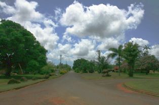
Coen is a rural town and coastal locality in the Shire of Cook, Queensland, Australia. The town of Coen is inland on the Peninsula Developmental Road, the main road on the Cape York Peninsula in far northern Queensland. In the 2021 census, the locality of Coen had a population of 320 people.

<span class="mw-page-title-main">Seisia, Queensland</span> Town in Queensland, Australia

Seisia is a coastal town and a locality in the Northern Peninsula Area Region, Queensland, Australia. In the 2021 census, the locality of Seisia had a population of 293 people.

<span class="mw-page-title-main">Somerset, Queensland</span> Suburb of Shire of Torres, Queensland, Australia

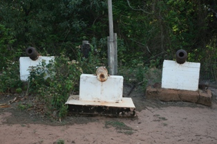
Somerset is a coastal locality split between the Shire of Torres and the Northern Peninsula Area Region, Queensland, Australia. In the 2016 census, Somerset had a population of 0 people.

<span class="mw-page-title-main">Mapoon, Queensland</span> Town in Queensland, Australia

Mapoon is a coastal town in the Aboriginal Shire of Mapoon and a locality split between the Aboriginal Shire of Mapoon and the Shire of Cook in Queensland, Australia. In the 2016 census, Mapoon had a population of 317 people.

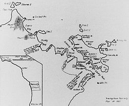
MiddleBrother Islet is a small uninhabited island at the east entrance of the Adolphus Channel of the Torres Strait, in Queensland, Australia. It is located about 7 km south of Mount Adolphus Island, 7 km east of Albany Island, and 1.5 km west of the South Ledge Reef.

<span class="mw-page-title-main">Mount Adolphus Island</span> Island in Queensland, Australia

Mount Adolphus Island, also called Muri or Mori in the native language, is an island of the Torres Strait Islands archipelago that is located at the very tip of Cape York Peninsula on the northern side of the Adolphus Channel, across from Albany Island and about 40 kilometres (25 mi) northeast of Bamaga in the far north region of Queensland, Australia.

<span class="mw-page-title-main">Prince of Wales Island (Queensland)</span> Island in Queensland, Australia

The Prince of Wales Island, or Muralag, is an island of the Torres Strait Islands archipelago at the tip of Cape York Peninsula within the Endeavour Strait of Torres Strait in Queensland, Australia. The island is situated approximately 20 km (12 mi) north of Muttee Heads which is adjacent to Bamaga and south of Thursday Island. It is within the locality of Prince Of Wales within the Shire of Torres. In the 2016 census, the locality had a population of 109 people.

<span class="mw-page-title-main">Shire of Torres</span> Local government area in Queensland, Australia

The Shire of Torres is a local government area located in Far North Queensland, Australia, covering large sections of the Torres Strait Islands and the northern tip of Cape York Peninsula north of 11°S latitude. It holds two distinctions—it is the northernmost Local Government Area in Australia, and is the only one to abut an international border – it is at one point just 73 kilometres (45 mi) from Papua New Guinea. It is administered from Thursday Island.

RMS <i>Quetta</i>

RMS Quetta was a Royal Mail Ship that was wrecked on the Far North Queensland coast of Australia on 28 February 1890. Quetta's sinking killed 134 of the 292 people on board, making it one of Queensland's biggest maritime catastrophes. It was caused by collision with an uncharted rock in the Adolphus Channel.

Ngawun is an extinct Mayi language once spoken on the Cape York Peninsula of Queensland, Australia, by the Wunumara and Ngawun peoples. The last speaker of the language was Cherry O'Keefe who died of pneumonia on 24 August 1977.

<span class="mw-page-title-main">Northern Peninsula Area Region</span> Local government area in Queensland, Australia

The Northern Peninsula Area Region is a local government area in Far North Queensland, Australia, covering areas on the northwestern coast of Cape York Peninsula. It was created in March 2008 out of three Aboriginal Shires and two autonomous Island Councils during a period of statewide local government reform. In June 2018, the area had a population of 3,069.

<span class="mw-page-title-main">Adolphus Channel</span> Channel in Northern Australia

The Adolphus Channel is a channel located in the Torres Strait, situated northeast of Cape York, in Queensland, Australia.

<span class="mw-page-title-main">Quetta Memorial Precinct</span> Historic site in Queensland, Australia

The Quetta Memorial Precinct is a heritage-listed Anglican church precinct in Douglas Street, Thursday Island, Shire of Torres, Queensland, Australia. The precinct comprises the All Souls and St Bartholomew's Cathedral Church, the Bishop's House, and the Church Hall. The precinct was built as a memorial to the 134 lives lost in the shipwreck of the RMS Quetta on 28 February 1890. The church was designed in 1892–1893 by architect John H. Buckeridge. It was added to the Queensland Heritage Register on 27 July 2001.

<span class="mw-page-title-main">Archer River, Queensland</span> Suburb of Shire of Cook, Queensland, Australia

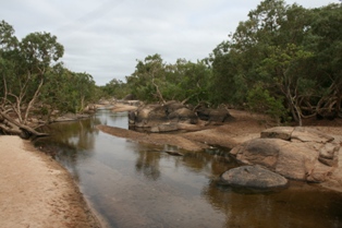
Archer River is a rural locality in the Shire of Cook, Queensland, Australia. In the 2016 census Archer River had a population of 22 people.

Cape York is the northernmost point of the mainland of Australia. It is within the Shire of Torres in Queensland.

References