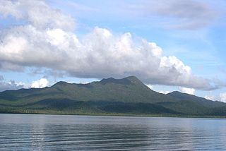
Hinchinbrook Island National Park is Australia's largest island national park. It is situated along the Cassowary Coast Queensland, Australia. The nearest capital city is Brisbane approximately 1,240 km to the south. Lucinda is 135 km or 1.5 hours drive north of Townsville being the closest North Queensland provincial city. Cairns a Far North Queensland provincial city is two and a half to 3 hours drive north from Cardwell. The main geographical features in the park are the rugged Hinchinbrook Island, including Mount Bowen, The Thumb, Mount Diamantina and Mount Straloch.

Cairns Airport is an international airport in Cairns, Queensland, Australia. Formerly operated by the Cairns Port Authority, the airport was sold by the Queensland Government in December 2008 to a private consortium. It is the seventh busiest airport in Australia. The airport is located 2.3 nautical miles north northwest of Cairns or 7 kilometres (4.3 mi) north of the Cairns central business district, in the suburb of Aeroglen. The airport lies between Mount Whitfield to the west and Trinity Bay to the east.
Lip-Air Pty Ltd, operating as Aero-Tropics Air Services (ATAS), was an airline based in Cairns, Queensland, Australia. Its main base was Cairns Airport, with its operating hub at Horn Island Airport.
Skytrans is an Australian owned and operated airline and air charter business based in Cairns. The airline operates RPT and charter services from Cairns, Horn Island, and Brisbane. After being placed in administration in January 2015, Skytrans returned to the skies on 31 March 2015.

Sunshine Coast Airport is an Australian international airport located in Marcoola, 10 km (6.2 mi) north of Maroochydore, at the northern end of the Sunshine Coast. It is approximately 90 km (56 mi) north of centre of Brisbane, within the South East Queensland agglomeration. The airport is owned by Sunshine Coast Regional Council and is the principal and only jet-capable airport serving an urban area of nearly 400,000 residents.
Orcas Island Airport is a public airport located 1 nautical mile north of the central business district of Eastsound on Orcas Island in San Juan County, Washington, United States.

Moa Island, also called Banks Island, is an island of the Torres Strait Islands archipelago that is located 40 kilometres (25 mi) north of Thursday Island in the Banks Channel of Torres Strait, Queensland, Australia. It is also a locality within the Torres Strait Island Region local government area. This island is the largest within the "Near Western" group. It has two towns, Kubin on the south-west coast and St Pauls on the east coast, which are connected by bitumen and a gravel road. In the 2016 census, Moa Island had a population of 448 people.
Mount Isa Airport is an airport serving the western Queensland city of Mount Isa, Australia. It is served by a variety of scheduled regional airlines, with flights to Brisbane, Townsville and Cairns as well as several other regional centres.

Hervey Bay Airport is the main airport for the city of Hervey Bay, Queensland, Australia and the Fraser Coast region which incorporates the nearby city of Maryborough.

Lord Howe Island Airport is an airport providing air transportation to Lord Howe Island. It is operated by the Lord Howe Island Board. Prior to its opening in September 1974, Lord Howe Island was served by flying boats from Rose Bay Water Airport.
Northern Peninsula Airport is an airport serving Bamaga, a town near the northern tip of the Cape York Peninsula and is located 5 nautical miles southeast of Injinoo in Queensland, Australia. The airport is operated by the Northern Peninsula Area Regional Council. It was known as Bamaga Airport or Bamaga/Injinoo Airport and had the ICAO code YBAM.
Boigu Island Airport is an airport serving Boigu Island in Queensland, Australia. It was officially opened as the Charlie Gibuma Memorial Airstrip on 26 July 1981 by Hon. Ken Tomkins, then Queensland Minister for Aboriginal and Island Affairs. The airport is operated by the Torres Strait Islands Regional Council.

Bundaberg Airport is a regional airport serving Bundaberg, a city in the Australian state of Queensland. It is located 2.5 nautical miles southwest of the city centre, on North Childers Road and Takalvan Street. The airport is owned and operated by the Bundaberg Regional Council. It is also known as Bundaberg Regional Airport.
Emerald Airport is an airport serving Emerald, a town located in the Central Highlands district of Queensland, Australia. It is located 6 km (4 mi) south of the Emerald town centre, on the Gregory Highway. The airport is operated by the Central Highlands Regional Council.
Lizard Island Airport is an airport on Lizard Island National Park in Queensland, Australia. It is served from Cairns by Hinterland Aviation.
The Torres Strait Island Region is a local government area in Far North Queensland, Australia, covering part of the Torres Strait Islands. It was created in March 2008 out of 15 autonomous Island Councils during a period of statewide local government reform. It has offices in each of its 15 communities, and satellite services in Thursday Island and in Cairns.

Whitsunday Airport (Shute Harbour) (IATA: WSY, ICAO: YSHR) is located in Flametree in the Whitsunday Region, Queensland, Australia. It is located between the popular tourist destinations of Airlie Beach, Shute Harbour and the Whitsunday Islands.

Hinterland Aviation is a regional airline and charter company based at Cairns Airport in Queensland, Australia. The airline operates scheduled flights from Cairns Airport, Horn Island Airport and Townsville Airport.
