
Bedourie is a town and a locality in the Shire of Diamantina, Queensland, Australia. In the 2016 census, Bedourie had a population of 122 people.
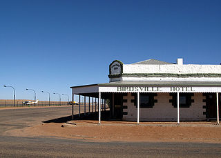
Birdsville is a rural town and locality in the Shire of Diamantina, Queensland, Australia. It is situated 10 kilometres (6 mi) north of the border of South Australia and Queensland. In the 2021 census, the locality of Birdsville had a population of 110 people. It is a popular tourist destination with many people using it as a starting point across the Simpson Desert.

The Diamantina River is a major river in Central West Queensland and the far north of South Australia.

The Channel Country is a region of outback Australia mostly in the state of Queensland but also in parts of South Australia, Northern Territory and New South Wales. The name comes from the numerous intertwined rivulets that cross the region, which cover 150,000 km². The Channel Country is over the Cooper and Eromanga geological basins and the Lake Eyre Basin drainage basin. Further to the east is the less arid Maranoa district.
Skytrans is an Australian owned and operated airline and air charter business based in Cairns. The airline operates RPT and charter services from Cairns, Horn Island, and Brisbane. After being placed in administration in January 2015, Skytrans returned to the skies on 31 March 2015.

Betoota is a ghost town within the locality of Birdsville, in the Shire of Diamantina, in the Channel Country of Central West Queensland, Australia. The last permanent resident, Sigmund Remienko, died in 2004. Betoota is situated on a gibber plain 170 kilometres (110 mi) east of Birdsville and 227 kilometres (141 mi) west of Windorah.

Mackay Airport located in South Mackay, Queensland, Australia is a major Australian regional airport that services the city of Mackay, with flights to the cities of Brisbane, Rockhampton, Townsville, Hamilton Island, Cairns, Sunshine Coast and Melbourne. In the year ending 30 June 2012, the airport handled 969,900 passengers making it the 14th busiest airport in Australia.

Whitsunday Coast Airport, also known as Proserpine Airport, is located in Gunyarra, Whitsunday Region, Queensland, Australia, 14 kilometres (8.7 mi) south of Proserpine. The airport serves the mainland and offshore islands with flights to Brisbane, Sydney and Melbourne.
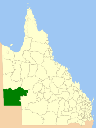
The Shire of Diamantina is a local government area in Central West Queensland, bordering South Australia and the Northern Territory. Its administrative centre is in the town of Bedourie.
Quilpie Airport is an airport serving Quilpie, Queensland, Australia. It is located 1 nautical mile west of Quilpie and operated by the Quilpie Shire Council. The airport received $242,666 for security upgrades from the Australian Government in 2006.
Windorah Airport is an airport serving Windorah, Queensland, Australia. It is operated by the Barcoo Shire Council. The airport received $183,578 in funds for security upgrades from the Australian Government in 2006.
Chinchilla Airport is an airport serving Chinchilla, Queensland, Australia.

Central West Queensland is a remote region in the Australian state of Queensland which covers 396,650.2 km2. The region lies to the north of South West Queensland and south of the Gulf Country. It has a population of approximately 12,387 people.

Glengyle Station is a pastoral lease that operates as a cattle station in central west Queensland.
Annandale Station, most commonly known as Annandale, is a pastoral lease that operates as a cattle station in central west Queensland. It is located on the tribal lands of the Wongkamala.
Pandie Pandie Station, most commonly known as Pandie Pandie, also often spelled as Pandi Pandi or Pandy Pandy, is a pastoral lease that operates as a cattle station in north east South Australia. It lies on the eastern edge of Karanguru territory.

Durrie Station is a pastoral lease that operates as a cattle station in Queensland, Australia.
Morney Plains Station, most commonly referred to as Morney Plains, is a pastoral lease that operates as a cattle station in south west Queensland.
Kidman's Tree of Knowledge is a heritage-listed tree at Glengyle Station, Bedourie, Shire of Diamantina, Queensland, Australia. It is also known as Tree of Knowledge. It was added to the Queensland Heritage Register on 21 October 1992.

