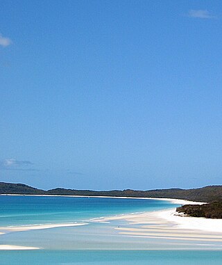
Whitsunday Islands is a national park in Queensland, Australia, 920 kilometres (570 mi) northwest of Brisbane. It contains Whitsunday Island and 31 others.

Airlie Beach is a coastal locality and resort town in the Whitsunday Region of Queensland, Australia. In the 2016 census, Airlie Beach had a population of 1,208 people.

Shute Harbour is a coastal locality and harbour in the Whitsunday Region of Queensland, Australia. It has port facilities and transport options for people seeking to access the Whitsunday Islands and holiday destinations.

Albany Airport, also known as Harry Riggs Albany Regional Airport, is an airport serving Albany, Western Australia. It is located 6 nautical miles northwest of Albany just off Albany Highway and operated by the City of Albany. It is the largest airport in the Great Southern region.
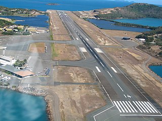
Hamilton Island Airport, also known as Great Barrier Reef Airport, is a privately owned public use aerodrome and is the primary airport of the Whitsunday Islands, as well as the airport of Hamilton Island. The airport is settled on mostly reclaimed land and is commercially served year-round by Jetstar, Virgin Australia and Qantas. Hamilton Island Airport handles flights from Sydney, Melbourne and Brisbane and is also the airport launch pad for scenic flights to the Great Barrier Reef and Whitehaven Beach. Private flights and charters also fly in, along with locally operated helicopters, light planes and seaplanes.

Whitsunday Coast Airport, also known as Proserpine Airport, is located in Gunyarra, Queensland, Australia, 14 kilometres (8.7 mi) south of Proserpine. The airport serves the mainland and offshore islands with flights to Brisbane, Sydney and Melbourne (Jetstar).
Northern Peninsula Airport is an airport serving Bamaga, a town near the northern tip of the Cape York Peninsula and is located 5 nautical miles southeast of Injinoo in Queensland, Australia. The airport is operated by the Northern Peninsula Area Regional Council. It was known as Bamaga Airport or Bamaga/Injinoo Airport and had the ICAO code YBAM.
Quilpie Airport is an airport serving Quilpie, Queensland, Australia. It is located 1 nautical mile west of Quilpie and operated by the Quilpie Shire Council. The airport received $242,666 for security upgrades from the Australian Government in 2006.

Winton Airport is an airport serving Winton, Queensland, Australia. It is located 3 nautical miles northeast of Winton and operated by the Winton Shire Council.
Ballera Airport is located at the Ballera gas plant in the locality of Durham in southwestern Queensland, Australia. There is one runway, and it is 5,906 ft × 98 ft long × wide.
Whitsunday Transit is an Australian bus and coach operator services in the Whitsunday Region. It operates 1 service under contract to the Queensland Government under the Translink banner.
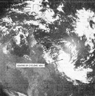
Severe Tropical Cyclone Ada was a small but intense tropical cyclone that severely impacted the Whitsunday Region of Queensland, Australia, in January 1970. It has been described as a defining event in the history of the Whitsunday Islands, and was the most damaging storm in the mainland town of Proserpine's history at the time. Forming over the far eastern Coral Sea in early January, the weather disturbance that would become Ada remained weak and disorganised for nearly two weeks as it slowly moved in a clockwise loop. Accelerating toward the southwest, the system was named Ada on 15 January. All observations of the fledgling cyclone were made remotely with weather satellite imagery until it passed over an automated weather station on 16 January. The extremely compact cyclone, with a gale radius of just 55 km (35 mi), intensified into a Category 3 severe tropical cyclone just before striking the Whitsunday Islands at 14:00 UTC on 17 January. At 18:30 UTC, Ada's eye crossed the coast at Shute Harbour. The cyclone made little inland progress before stalling northwest of Mackay and dissipating on 19 January.

Flametree is a coastal locality in the Whitsunday Region, Queensland, Australia. In the 2021 census, Flametree had a population of 143 people.
Mandalay is a coastal locality in the Whitsunday Region, Queensland, Australia. In the 2021 census, Mandalay had a population of 338 people.

Jubilee Pocket is a residential locality in the Whitsunday Region, Queensland, Australia. In the 2021 census, Jubilee Pocket had a population of 2,047 people.
Whitsunday is a coastal town in the locality of Airlie Beach in the Whitsunday Region, Queensland, Australia.
Proserpine–Shute Harbour Road is a continuous 34.3 kilometres (21.3 mi) road route in the Whitsunday local government area of Queensland, Australia. The route is designated as State Route 59. It is a state-controlled regional road.

