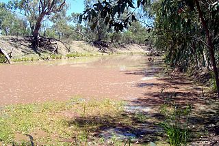
The Culgoa River is a river that is part of the Darling catchment within the Murray–Darling basin and is located in South West Queensland.

The Balonne River, part of the Murray-Darling Basin system, is a short yet significant part of the inland river group of South West Queensland, Australia.

St George is a rural town and locality in the Shire of Balonne, Queensland, Australia. It is the administrative centre for the Shire of Balonne. In the 2021 census, St George had a population of 3,130 people.

Hebel is a rural town and locality in the Shire of Balonne, Queensland, Australia. It is on the border of Queensland and New South Wales. In the 2016 census, Hebel had a population of 67 people.
Dirranbandi is a rural town and locality in the Shire of Balonne, Queensland, Australia. The locality is on the border of Queensland with New South Wales. In the 2021 census, the locality of Dirranbandi had a population of 610 people.

Mungindi is a town and locality on the border of New South Wales (NSW) and Queensland, Australia. The town is within Moree Plains Shire in New South Wales. Within Queensland, the locality is split between the Shire of Balonne and the Goondiwindi Region with the town in the Shire of Balonne. It possesses a New South Wales postcode. Mungindi sits on the Carnarvon Highway and straddles the Barwon River which is the border between New South Wales and Queensland. At the 2016 census, Mungindi had a population of 601 on the New South Wales side, while the population on the Queensland side was 146.

Collarenebri is a town in north western New South Wales, Australia. The town is in the Walgett Shire Local Government Area and is situated on the Barwon River approximately 75 kilometres (47 mi) northeast of Walgett and south west of Mungindi on the Gwydir Highway. It is 16 km (9.9 mi) from Pokataroo which was the nearest railway town prior to closure of the rail service there. The town is 150 metres (490 ft) above sea level. Collarenebri is one of three towns ending in 'BRI' in Northern New South Wales.

The Shire of Balonne is a local government area in South West Queensland, Australia, over 500 kilometres (310 mi) from the state capital, Brisbane. It covers an area of 31,104 square kilometres (12,009.3 sq mi), and has existed as a local government entity since 1879. It is headquartered in its main town, St George.

Goodooga is a town in the Australian state of New South Wales in Brewarrina Shire on the eastern bank of the Bokhara River. It is near Brewarrina and Lightning Ridge, its closest neighbour. The town lies 20 kilometres (12 mi) south of the Queensland border, and the border town of Hebel.

Thallon is a town and a locality in the Shire of Balonne, Queensland, Australia. In the 2021 census, the locality of Thallon had a population of 231 people.

The South Western line is a narrow gauge railway line in the southern part of the state of Queensland, Australia. It junctions from the Southern line immediately south of Warwick station and proceeded westwards for a distance of 413 km to the town of Dirranbandi. A western extension to Boomie in New South Wales, approved by the Queensland Parliament in 1914, was never constructed. The Thallon-to-Dirranbandi section was closed on 2 September 2010.

The Moonie River (Mooni River) is a river in Shire of Balonne, Queensland and Walgett Shire, New South Wales, both in Australia. It is a perennial river of the Barwon catchment within the Murray–Darling basin.
The Bokhara River, a watercourse that is part of the Barwon catchment within the Murray–Darling basin, is located in the South Downs region of Queensland, flowing downstream into the north–western slopes of New South Wales, Australia. It flows through the lower Balonne floodplain.

Narran River, a watercourse of the Barwon catchment within the Murray–Darling basin, is located in the Southern Downs district of Queensland and Orana district of New South Wales, Australia.

Angledool is a locality in upper western New South Wales near the southern border of Queensland, one kilometre east of the Castlereagh Highway and approximately 45 kilometres north of Lightning Ridge. At the 2016 census, Angledool had a population of 58 people.

South West Queensland is a remote region in the Australian state of Queensland which covers 319,808 km2 (123,479 sq mi). The region lies to the south of Central West Queensland and west of the Darling Downs and includes the Maranoa district and parts of the Channel Country. The area is noted for its cattle grazing, cotton farming, opal mining and oil and gas deposits.
Balonne was an electoral district of the Legislative Assembly in the Australian state of Queensland from 1873 to 1932, and again from 1950 to 1992. It was named after the Balonne River.

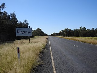
Bungunya is a rural town and locality in the Goondiwindi Region, Queensland, Australia. The locality is on the border of Queensland and New South Wales. In the 2016 census, Bungunya had a population of 75 people.
Daymar is a rural town and locality in the Goondiwindi Region, Queensland, Australia. In the 2016 census, the locality of Daymar had a population of 37 people.

Talwood is a town in the rural locality of North Talwood in Goondiwindi Region, Queensland, Australia.


